Tópico de monitorização e discussão do clima global, ciclos, padrões e teleconexões em 2010
Links úteis:
Clima Global
 NOAA National Climatic Data Center (NCDC)
NASA Goddard Institute for Space Studies (GISS)
Remote Sensing Systems (RSS)
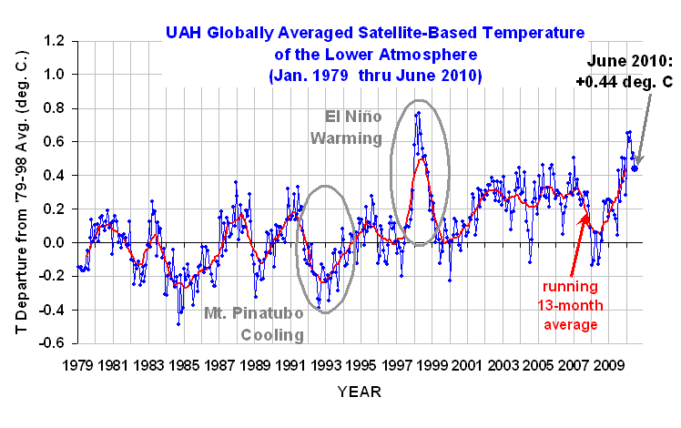
University of Alabama in Huntsville (UAH)
NAO - Oscilação Atlântico Norte
NOAA Climate Prediction Center - NAO (North Atlantic Oscillation)
North Atlantic Oscillation
The Arctic Oscillation (AO) and the North Atlantic Oscillation (NAO)
North Atlantic Oscillation
AO - Oscilação Ártico
Climate Prediction Center - Arctic Oscillation
The Arctic Oscillation (AO) and the North Atlantic Oscillation (NAO)
Arctic Oscillation (AO) time series
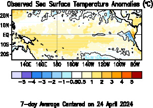
ENSO - El Nino-Oscilação Sul
NOOA Climate Prediction Center - El Niño / Southern Oscillation (ENSO)
BOM Australia Seasonal Outlooks ENSO Wrap-Up
AAO Oscilação Antártica
Antarctic Oscillation - Climate Prediction Center
PNA Padrão Pacífico-América do Norte
Climate Prediction Center - Pacific/North American Pattern
MJO Oscilação Madden Julian
Climate Prediction Center - Madden Julian Oscillation
Wikipedia Madden–Julian oscillation
Links úteis:
Clima Global
NAO - Oscilação Atlântico Norte
AO - Oscilação Ártico
ENSO - El Nino-Oscilação Sul
AAO Oscilação Antártica
PNA Padrão Pacífico-América do Norte
MJO Oscilação Madden Julian