Actividade Vulcânica 2017

Estado
Fechado para novas mensagens.

luismeteo3

Furacão
Registo
14 Dez 2015
Mensagens
17,112
Local
Fatima (320m)
Estas traduções são do melhor, mas cá vai...

Two earthquakes have been reported at Bárðarbunga now after noon. The first one rode over eight o'clock in two and was 3.9 in strength. The other came two minutes later and was also 3.9. The previous earthquake occurred about 8 kilometers north-east of Bárðarbunga. The latter rode over 6.1 kilometers northeast of Bárðarbunga.
Geologist Björn Oddsson, in a conversation with the news agency yesterday, said that Bárðarbunga would have been a significant part of the earthquake and that the earthquakes had risen sharply. The volcano could resent the fire. Many are probably still in fresh memory when Bárðarbunga dates from 2014 to 2015. A considerable amount of geothermal energy is currently in the björðurbunga area.

A few eclipses have been observed. There are no signs of erosion, according to the website of the Icelandic Meteorological Office.

The news will be updated.

http://ruv.is/frett/tveir-39-stiga-skjalftar-i-bardarbungu


luismeteo3

Furacão
Registo
14 Dez 2015
Mensagens
17,112
Local
Fatima (320m)
From RUV via our favourite translating device

Geothermal power causes the sewer in Öræfajökull 21.11.2017

The results of geoscientist surveys on water from Kvía to Öræfajökull indicate that the outflow of geothermal water is the cause of melting in the glacial kettle. There are no signs of fungal disease, indicating that the nitrogen has not penetrated into the geothermal system under the carton.

“These are important information, they strongly suggest that kvika did not get into the geothermal system itself. It is likely that the major causes of earthquakes are magnet movements at a significant depth below the volcano. If this scenario ends with volcanic eruption, it’s not very far away, “says Magnús Tumi Gudmundsson, geophysicist in a conversation with the news agency.
Water samples were taken from the river last Saturday, these are the results from them. Andri Stefánsson, Professor of Geoscience at the University of Iceland, interpreted the results.

:eek::eek::eek:
 
  • Gosto
Reactions: Wessel1985 e Cinza

luismeteo3

Furacão
Registo
14 Dez 2015
Mensagens
17,112
Local
Fatima (320m)
History of Öræfajökull
Albert / 2 hours ago

...

The mountain

The glacier-covered mountain of Öræfajökull dominates the skyline here. Its caldera, 14 km2 in areas, is filled with ice, 550 meter deep. Around the caldera rim are the individual peaks of the volcano: Hvannadalshnúkur , Rótarfjallshnúkur , the twin peaks of Hnappar, Sveinstindur and Sveinsgnípa. Hvannadalshnúkur is the tallest, at 2110 meter, and is the highest mountain in Iceland (albeit by a margin of only ten meter). The mountain is 20 km across at its base near sea level, making it rather steep. A quarter of its base area is covered by the glacier. The volume of the mountain is around 370 km3, which makes it the largest volcano in Iceland by volume as well as height.

Öræfajökull has another claim to fame: it has Iceland’s highest amount of snowfall. Each year, over 10 meter of snow accumulates at the summit. The glacier did not get there by accident! The rain in Iceland comes mainly from the south (the north is drier), and Öræfajökull is close to the sea – it captures quite a lot of it. At sea level the weather is not quite as wet, and there the climate is mild – for Iceland!

The current mountain formed when two older, adjacent volcanoes merged. This was during the ice ages, when the glaciers hemmed in the eruptions. They kept the lava close to the eruption sites, and forced the mountain to build upward rather than outward. This is why the mountain is both tall and steep: it was made that way by the containing ice.

... http://www.volcanocafe.org/history-of-öraefajökull/
 
  • Gosto
Reactions: Wessel1985 e Cinza

vitoreis

Cumulus
Registo
28 Ago 2012
Mensagens
206
Local
Faro
luismeteo3 o que acha do Yellowstone?? É só fogo de vista este tremer ao longo deste ano ou poderemos vir a ter uma surpresa??

Yellowstone geologist talks threat of supervolcano eruption

http://www.nbcmontana.com/news/ktvm...lks-threat-of-supervolcano-eruption/659871422
Este tipo de artigos são frequentes e recorrentes... vê, inclusive, como termina:
.....

"We would likely see years to decades of anomalous activity at Yellowstone before any kind of a significant eruption,” Stickney said.

For now, according to Hungerford, guests like Ringstad can take in the park and its geothermal features created by the last supervolcano eruption without worry.
......
 
  • Gosto
Reactions: Wessel1985 e Cinza

MSantos

Moderação
Registo
3 Out 2007
Mensagens
10,670
Local
Aveiras de Cima

The Weatherman

Cumulus
Registo
10 Fev 2009
Mensagens
455
Local
Braga
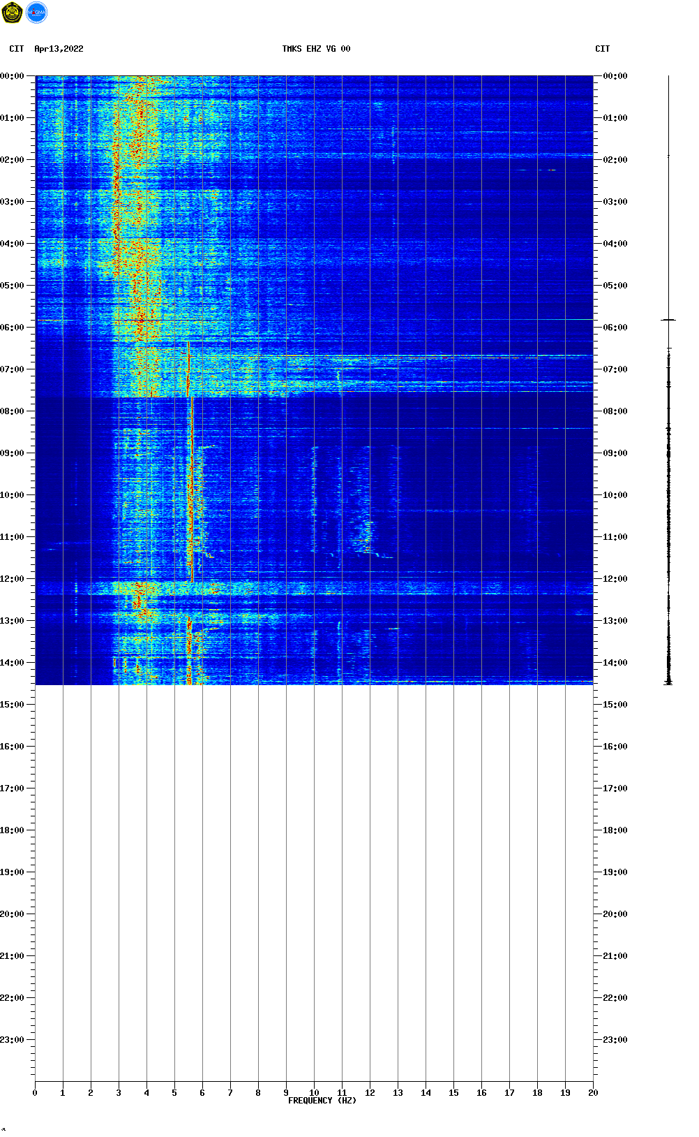
Tremores harmónicos...

TMKS.png
 

The Weatherman

Cumulus
Registo
10 Fev 2009
Mensagens
455
Local
Braga
Segundo o relatório oficial: "There is a continuous tremor from 14:00 WITA to 18:00 WITA, with amplitude 1 - 9 mm (dominant: 4 mm) Non-harmonic"

Agung 20171121/0939Z
(1) VOLCANO OBSERVATORY NOTICE FOR AVIATION - VONA
(2) Issued : 20171121/0939Z
(3) Volcano : Agung (264020)
(4) Current Aviation Colour Code : ORANGE
(5) Previous Aviation Colour Code : yellow
(6) Source : Agung Volcano Observatory
(7) Notice Number : 2017AGU15
(8) Volcano Location : S 08 deg 20 min 31 sec E 115 deg 30 min 29 sec
(9) Area : Bali, Indonesia
(10) Summit Elevation : 10054 FT (3142 M)
(11) Volcanic Activity Summary : Eruption with volcanic ash cloud started at 0905 UTC (1705 LT). Eruption and ash emission is continuing.
(12) Volcanic Cloud Height : Best estimate of ash-cloud top is around 12294 FT (3842 M) above sea level, may be higher than what can be observed clearly. Source of height data: ground observer.
(13) Other Volcanic Cloud Information : Ash cloud moving to east - south east.
(14) Remarks : Seismic activity is characterized by volcano tectonic earthquakes.
 
Estado
Fechado para novas mensagens.