Vai chegar com cat 4
Texans flee 7 coastal counties ahead of IkeStory Highlights
NEW: Ike could swell to Category 4 hurricane when it hits Texas coast
Mandatory, voluntary evacuations under way in at least seven Texas counties
Texans in low-lying areas and mobiles homes urged to get out
Next Article in U.S. »
Read VIDEO PHOTOS MAP
(CNN) -- Texans are fleeing from seven coastal counties ahead of Hurricane Ike on Thursday after officials ordered mandatory evacuations and planned even more voluntary ones.
Earl Barnes waits to be evacuated from a senior center in Corpus Christi, Texas, on Wednesday.
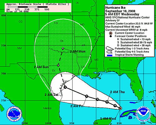
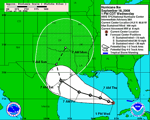
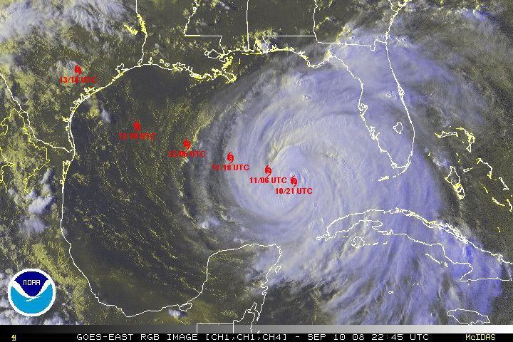
1 of 3 more photos » Forecasters said the storm could slam into the Texas coast -- south of Galveston -- as a powerful Category 4 storm late Friday or early Saturday.
Aransas County has ordered a mandatory evacuation of all nonessential government employees, becoming the latest county to urge residents to flee.
In Galveston, city officials ordered mandatory evacuations for part of the island town beginning at 7 a.m. CT (8 a.m. ET) Thursday. The rest of the town will be under a voluntary evacuation order. Only residents will be required to evacuate on the western end of the island.
Mayor Lyda Ann Thomas defended this decision, saying current models call for Galveston to be hit with winds and rain only equivalent to a Category 1 hurricane.
"We do not intend to evacuate Galveston Island," she said. "It's the last thing we want to do. Our job is to protect lives and property, [and] right now we feel that sheltering in place is the best action for our citizens to take."
Farther up the Gulf Coast and closer to where the National Hurricane Center predicts a direct hit, Brazoria County ordered a mandatory evacuation to begin at 8 a.m. CT (9 a.m. ET) Thursday. Some other Texas localities have ordered mandatory evacuations, while others have left the decision to depart up to residents.
Don't Miss
KPRC: Galveston gears up for Ike
KSAT: Hospitals fly kids away from Ike
Hurricane tears up Grand Turk tourism
iReport.com: Are you in Ike's path? Send your pics, video
Impact Your World
See how you can make a difference
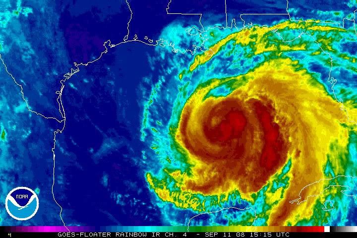
As of 5 a.m. ET Thursday, the Category 2 storm -- with top sustained winds near 100 mph -- was about 620 miles east of Brownsville, Texas, and about 285 miles southeast of the Mississippi River, the hurricane center said. Track the storm »
Hurricane-force winds extended out up to 115 miles from the storm's center, and tropical storm-force winds extended out up to 255 miles forecasters reported.
In Matagorda County, southwest of Galveston, officials ordered a mandatory evacuation for all areas except the cities of Bay City and Van Vleck.
The evacuation must be completed by at 6 p.m. (7 p.m. ET) Thursday. Galveston is likely to experience a high tidal surge, officials said, urging people living in low-lying areas or mobile homes to get out soon.
"One of the things that the public has to understand if they decide to stay, there will be a period of time during this storm when they will absolutely be on their own," Brazoria County Sheriff Charles Wagner said.
"There will be no medical services; there will be no fire department; there will be no law enforcement, groceries, gasoline, drugs, electricity."
The center issued a tropical storm warning from the Mississippi River's mouth to Cameron, Louisiana, and a hurricane watch from Cameron to Port Mansfield, Texas, about 60 miles south of Brownsville. Tropical storm warnings mean winds of 39 mph to 73 mph are expected within a day, and a hurricane watch means winds of 74 and higher are expected within 36 hours.
"Hurricane Ike is now in the Gulf of Mexico and making its approach toward our coast," Gov. Rick Perry said in a statement. "The next few days will be crucial for residents to follow the direction of local leaders and to take the necessary steps to protect themselves and their families."
Perry put 7,500 National Guard members on standby and issued a disaster declaration for 88 counties.
About 1,350 buses as well as ambulances and paramedic buses were available to support evacuations. The vehicles were positioned near Houston and Matagorda, Nueces and Victoria counties, the governor's office said.
President Bush declared an emergency, making federal funds available for the state to prepare for the storm.
Corpus Christi officials also began the evacuation process for residents with special needs, supplying buses to transport them out of town.
Voluntary evacuations were issued in San Patricio and Victoria counties and parts of Jackson County, according to the governor's office.
More than 1,300 inmates from the Texas Correctional Institutions Division's Stevenson Unit in Cuero were being evacuated to facilities in Beeville and Kenedy, Perry's office said, and 597 were transferred from the substance abuse Glossbrenner Unit in San Diego, in south Texas, to Dilley.
Naval air stations in Texas also began to prepare for Hurricane Ike's expected arrival. Naval Air Station Kingsville was to begin moving about 50 aircraft to El Paso, San Antonio and Fort Worth on Wednesday afternoon, the public affairs office there said. Naval Air Station Corpus Christi also will move about 75 aircraft to other Texas locations.
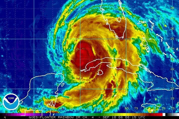
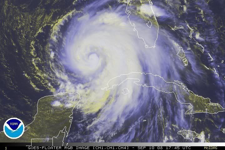
Evacuations appeared to have saved lives in Cuba when Ike slammed into the island. Four deaths were reported from the storm, according to the Cuban government. The Cuban Civil Defense brought buses or trucks to take people to shelters. See the damage from the storm »
The United States, which provided $100,000 in emergency aid to communist-run Cuba through private aid agencies after Hurricane Gustav hit the island August 30, said that it was considering additional emergency aid for Cuba because of Ike. Watch as winds and waves pound Cuba »
Also, the United States said it will lift restrictions on cash and humanitarian assistance sent to Cuba for the next 90 days. The move will allow nongovernmental organizations to provide assistance and cash donations.
The storm pounded Grand Turk Island in the Turks and Caicos chain, putting a strain on the British territory's tourism industry. Watch houses lie in heaps on Grand Turk »
Flooding and rains from Ike's outer bands have been blamed for 70 deaths in Haiti.
E-mail to a friend
Share this on:
Mixx
Digg
Facebook
del.icio.us
reddit
StumbleUpon
MySpace
| Mixx it | Share
CNN's Mike Mount contributed to this report.
All About Texas • Cuba • Haiti
 não tem piada mas quem diria que ele iria fazer o mesmo trajecto do Gustav, ao passar perto do mesmo sitio, é preciso ter azar.
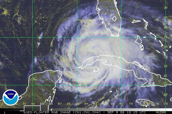


")