Previsão e Seguimento Furacões (Atlântico 2017)
- Thread starter Felipe Freitas
- Data de início
-
Meteogramas MeteoPT: Capitais de Distrito/Açores/Madeira | Coordenadas
Seguimento Meteorológico: Litoral Norte | Interior Norte e Centro | Litoral Centro | Sul | Açores e Madeira | Livre Previsões: Curto e médio prazo: até 2 semanas | Longo prazo: mensal e sazonal (Regras e links úteis nos 1ºs posts)
Facebook | Avisos IPMA/Alertas ANEPC
You are using an out of date browser. It may not display this or other websites correctly.
You should upgrade or use an alternative browser.
You should upgrade or use an alternative browser.

Depois do José, o próximo mistério é o ex-Lee. Alguns modelos metem-no a pastar, desta vez, no meio do Atlântico. Por agora é o único evento tropical que pode eventualmente afetar os Açores.
Quanto à Maria, grande quebra. No aviso 18A tem 100 nós, 20 nós (37 km/h) abaixo da intensidade do aviso 18. É um cat. 3 fraco a moderado.
Quanto à Maria, grande quebra. No aviso 18A tem 100 nós, 20 nós (37 km/h) abaixo da intensidade do aviso 18. É um cat. 3 fraco a moderado.
luismeteo3
Furacão
luismeteo3
Furacão
Ryan McGee- @ESPNMcGee 2h ago
Just received email from friend in San Juan, Puerto Rico. "Roads underwater and no roofs on anything in every direction as far as I can see"
(((Ben)))- @bdh_photos 37m37 minutes ago
San Juan Mayor Carmen Yulín Cruz said in an interview that “we’re looking at four to six months without electricity.”
Ryan Davidson @RyanDavidsonWX 2m2 minutes ago
Mayor of San Juan, Carmen Yulin Cruz, said Puerto Rico will be without power for 4 MONTHS. #Maria #SanJuan #PuertoRico
luismeteo3
Furacão
Em 2015:
O Irma passou ao lado e ainda assim foi o caos.
As ilhotas vão demorar inúmeros anos a recuperar mesmo que não sejam atingidas por mais nenhum ciclone significativo. PR não deverá ser muito diferente.
O Irma passou ao lado e ainda assim foi o caos.
"This is total devastation," said Carlos Mercader, a spokesman for Puerto Rico's governor. "Puerto Rico, in terms of the infrastructure, will not be the same. ... This is something of historic proportions."
As ilhotas vão demorar inúmeros anos a recuperar mesmo que não sejam atingidas por mais nenhum ciclone significativo. PR não deverá ser muito diferente.
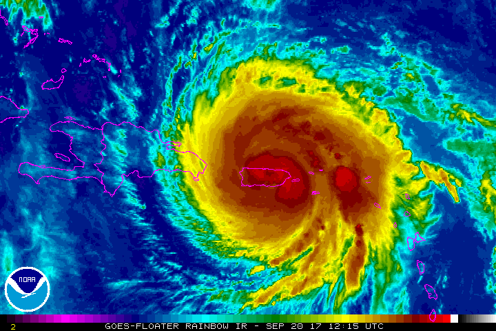
Maria, aviso 19. Está a variar entre a cat. 2 muito forte e a cat. 3 muito fraca.
A passagem pelas ilhas Turcas e Caicos, enquanto cat. 3 moderado, deve ocorrer durante o final de madrugada de amanhã.
The aircraft measured a maximum flight-level wind of 106 kt to the east of the center and SFMR surface winds as high as 91 kt. The initial intensity is therefore set to 95 kt.
It may take some time for Maria's structure to reorganize itself now that it is back over water. Although the intensity models are not all that enthusiastic about strengthening, the environment looks conducive for intensification, and the NHC forecast lies at the upper bound of the guidance, closest to the HWRF solution. It would not be surprising, however, if Maria eventually strengthens more than shown here.
FORECAST POSITIONS AND MAX WINDS
INIT 20/2100Z 18.8N 67.3W 95 KT 110 MPH
12H 21/0600Z 19.5N 68.2W 95 KT 110 MPH
24H 21/1800Z 20.5N 69.3W 100 KT 115 MPH
36H 22/0600Z 21.6N 70.3W 105 KT 120 MPH
A passagem pelas ilhas Turcas e Caicos, enquanto cat. 3 moderado, deve ocorrer durante o final de madrugada de amanhã.
Última edição:
luismeteo3
Furacão
luismeteo3
Furacão
luismeteo3
Furacão
Toda população está sem luz em Porto Rico e estima-se que possa demorar meses para ser restabelecido em todo território.
Grandes inundações foram registradas, com acumulados em áreas serranas próximo dos 1000 mm.
Maria se tornou quarto furacão com menor landfall em território americano e décimo mais intenso da história em pressão.
Grandes inundações foram registradas, com acumulados em áreas serranas próximo dos 1000 mm.
Maria se tornou quarto furacão com menor landfall em território americano e décimo mais intenso da história em pressão.
Depois de devastar Porto Rico, Maria rapidamente está se organizando.
Poderia se fortalecer para pelo menos categoria 4 amanhã.

Poderia se fortalecer para pelo menos categoria 4 amanhã.
Partilhar: