Super Ciclone Kyarr (Índico)
- Thread starter luismeteo3
- Data de início
-
Meteogramas MeteoPT: Capitais de Distrito/Açores/Madeira | Coordenadas
Seguimento Meteorológico: Litoral Norte | Interior Norte e Centro | Litoral Centro | Sul | Açores e Madeira | Livre Previsões: Curto e médio prazo: até 2 semanas | Longo prazo: mensal e sazonal (Regras e links úteis nos 1ºs posts)
Facebook | Avisos IPMA/Alertas ANEPC
You are using an out of date browser. It may not display this or other websites correctly.
You should upgrade or use an alternative browser.
You should upgrade or use an alternative browser.

India Meteorological Department
Tropical Cyclone Advisory #15 - 17:30 PM IST October 26 2019
VERY SEVERE CYCLONIC STORM KYARR (ARB03-2019)
=========================================
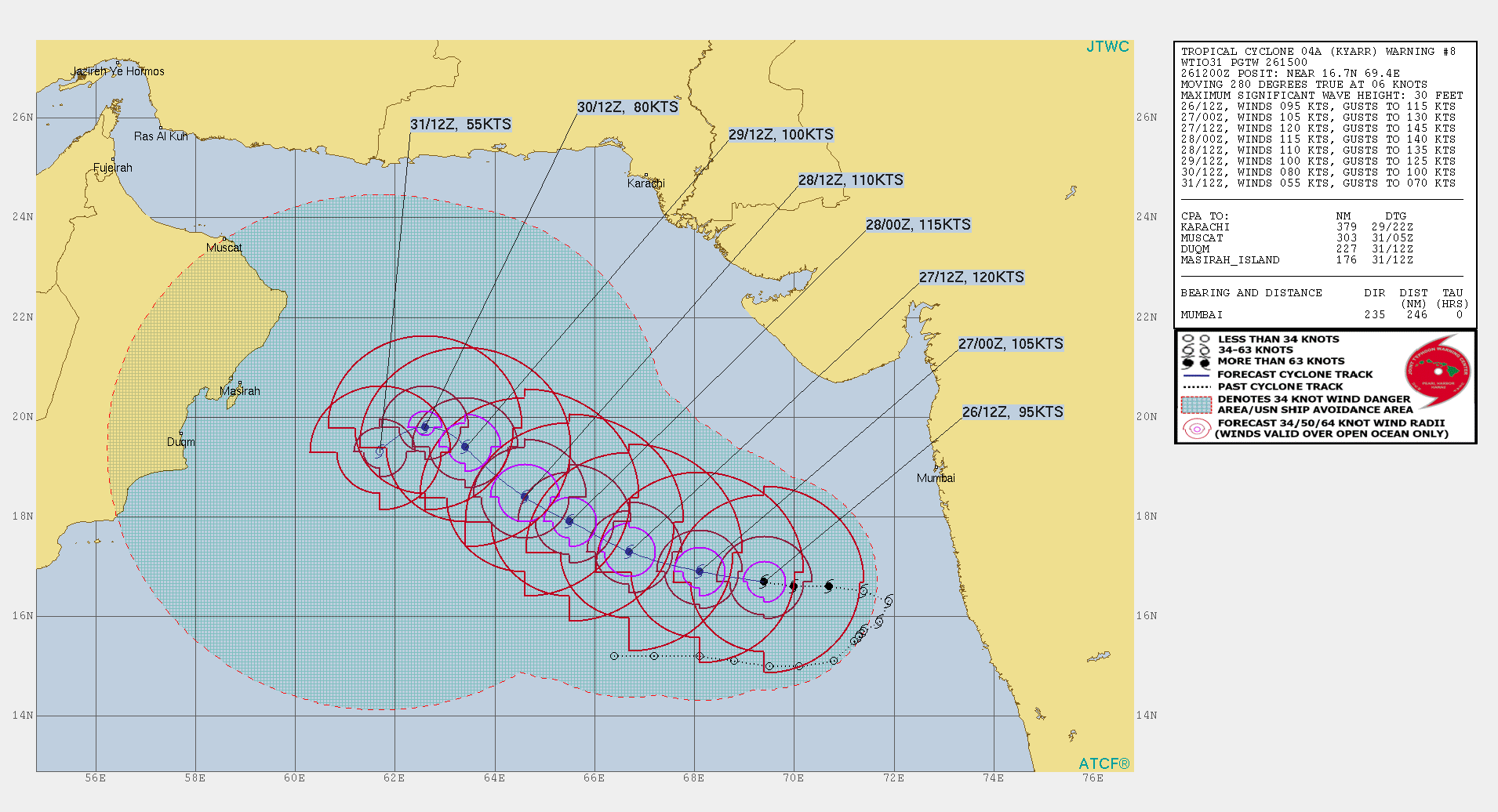
At 12:00 PM UTC, The very severe cyclonic storm ‘KYARR’ moved west northwestwards with a speed of 11 km/h during past 6 hrs and lays centered near 16.7N 69.4E over east central Arabian Sea, about 420 km west southwest of Ratnagiri (Maharashtra), 450 km west southwest of Mumbai (Maharashtra) and 1630 km east outheast of Salalah (Oman).
It is very likely to move west northwestwards towards Oman coast during next 5 days. It is very likely to intensify further into an extremely severe cyclonic storm during next 6 hours.
Forecast and Intensity
================
12 HRS: 16.9N 68.0E - 95 knots (Extremely Severe Cyclonic Storm)
24 HRS: 17.4N 66.5E - 95 knots (Extremely Severe Cyclonic Storm)
48 HRS: 18.5N 64.3E - 95 knots (Extremely Severe Cyclonic Storm)
72 HRS: 19.3N 62.7E - 80 knots (Very Severe Cyclonic Storm)
Satellite images indicate banding eye pattern with tightly wrapped curved bands visible. Centre clearly exposed in microwave imagery. As per the satellite imagery, the current intensity of the system is T4.5. Associated broken low to medium clouds with embedded intense to very intense convection lies over east central Arabian sea between13.5N to 18.0N east of long 68.0E to 72.5E. The minimum cloud top temperature is -93C.
3 minute sustained winds near the center is 85 knots with gusts of 95 knots. The state of the sea is phenonemal around the center. Estimated central pressure of the severe cyclonic storm is 974 hPa.
The Madden-Julian oscillation lies in the phase 2 with amplitude greater than 1. It will remain in the same phase during next one more day and then enter into phase 3 with amplitue less than 1. Considering the environmental conditions, total precipitable water imageries indicate warm air advection to the system centre. The low level relative vorticity has incresed and now is 300 x10-5 sec-1 over the system centre. The lower level convergence has also incresed and now is about 20 x10 -5 s-1 to the southeast of the system centre. The upper level divergence has decreased and now is about 20 x10-5s-1 to the northeast of system centre. The vertical wind shear is low (5-10 knots) around the system center. Sea surface temperature over most parts of east central Arabian sea is 29-30C and tropical cyclone heat potential is 80 kj/cm2 over the region thereby favoring further intensification. Both poleward and equatorward outflow is taking place in the upper tropospheric levels all these dydnamic and thermodynamic conditions favour further rapid intensification. However, as the system will track west northwestwards and enter west central Arabian sea, it is likely to experience colder sea surface temperatures, lower upper ocean heat content and cold and dry air intrusion into the system centre, causing gradual weakening of the system from October 30th.
Tropical Cyclone Advisory #15 - 17:30 PM IST October 26 2019
VERY SEVERE CYCLONIC STORM KYARR (ARB03-2019)
=========================================
At 12:00 PM UTC, The very severe cyclonic storm ‘KYARR’ moved west northwestwards with a speed of 11 km/h during past 6 hrs and lays centered near 16.7N 69.4E over east central Arabian Sea, about 420 km west southwest of Ratnagiri (Maharashtra), 450 km west southwest of Mumbai (Maharashtra) and 1630 km east outheast of Salalah (Oman).
It is very likely to move west northwestwards towards Oman coast during next 5 days. It is very likely to intensify further into an extremely severe cyclonic storm during next 6 hours.
Forecast and Intensity
================
12 HRS: 16.9N 68.0E - 95 knots (Extremely Severe Cyclonic Storm)
24 HRS: 17.4N 66.5E - 95 knots (Extremely Severe Cyclonic Storm)
48 HRS: 18.5N 64.3E - 95 knots (Extremely Severe Cyclonic Storm)
72 HRS: 19.3N 62.7E - 80 knots (Very Severe Cyclonic Storm)
Satellite images indicate banding eye pattern with tightly wrapped curved bands visible. Centre clearly exposed in microwave imagery. As per the satellite imagery, the current intensity of the system is T4.5. Associated broken low to medium clouds with embedded intense to very intense convection lies over east central Arabian sea between13.5N to 18.0N east of long 68.0E to 72.5E. The minimum cloud top temperature is -93C.
3 minute sustained winds near the center is 85 knots with gusts of 95 knots. The state of the sea is phenonemal around the center. Estimated central pressure of the severe cyclonic storm is 974 hPa.
The Madden-Julian oscillation lies in the phase 2 with amplitude greater than 1. It will remain in the same phase during next one more day and then enter into phase 3 with amplitue less than 1. Considering the environmental conditions, total precipitable water imageries indicate warm air advection to the system centre. The low level relative vorticity has incresed and now is 300 x10-5 sec-1 over the system centre. The lower level convergence has also incresed and now is about 20 x10 -5 s-1 to the southeast of the system centre. The upper level divergence has decreased and now is about 20 x10-5s-1 to the northeast of system centre. The vertical wind shear is low (5-10 knots) around the system center. Sea surface temperature over most parts of east central Arabian sea is 29-30C and tropical cyclone heat potential is 80 kj/cm2 over the region thereby favoring further intensification. Both poleward and equatorward outflow is taking place in the upper tropospheric levels all these dydnamic and thermodynamic conditions favour further rapid intensification. However, as the system will track west northwestwards and enter west central Arabian sea, it is likely to experience colder sea surface temperatures, lower upper ocean heat content and cold and dry air intrusion into the system centre, causing gradual weakening of the system from October 30th.

India Meteorological Department
Tropical Cyclone Advisory #25 - 17:30 PM IST October 27 2019
SUPER CYCLONIC STORM KYARR (ARB03-2019)
=========================================
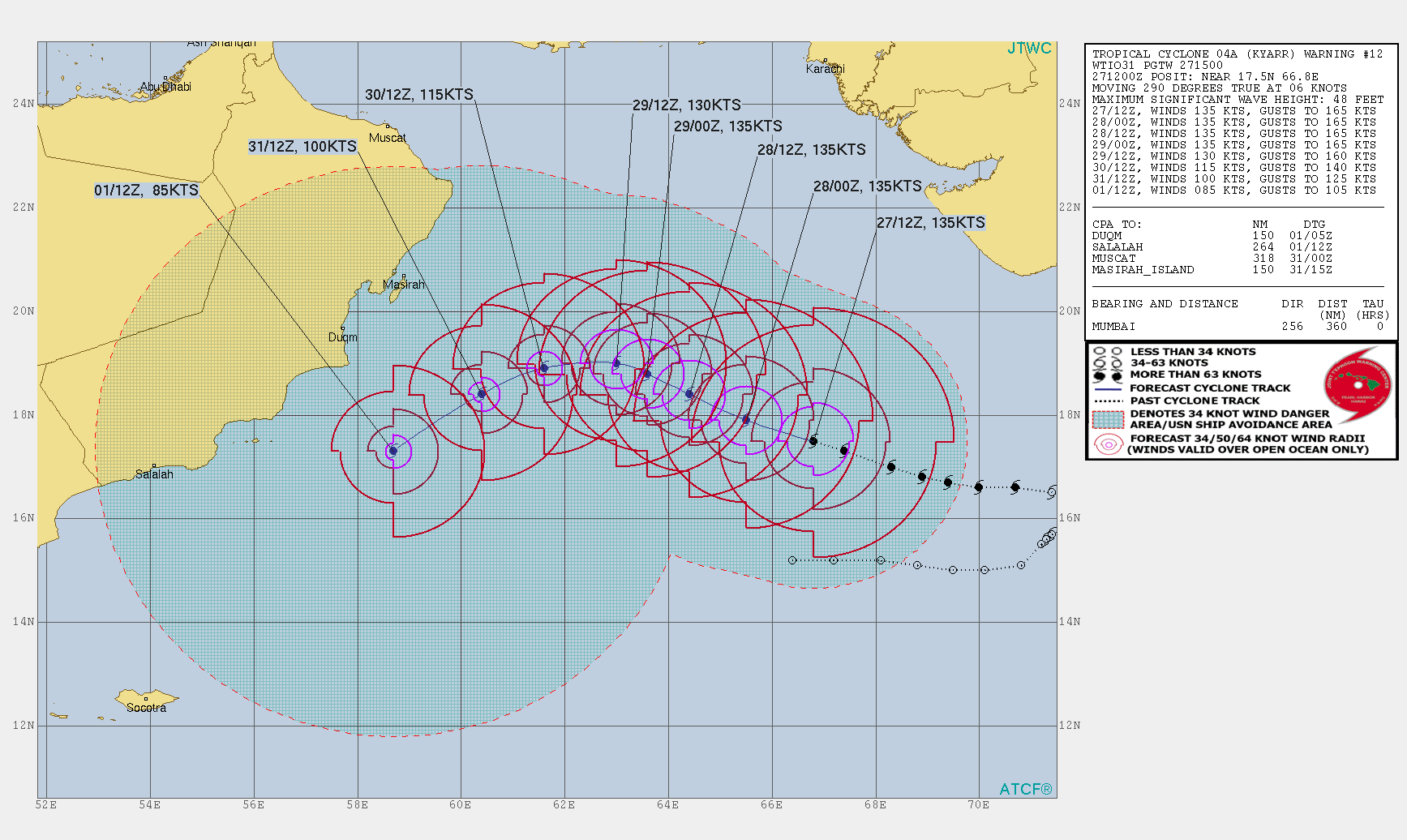
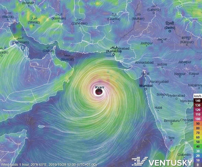
At 12:00 PM UTC, The super cyclonic storm ‘Kyarr’ moved west northwestwards with a speed of 12 km/h during past 6 hours and lays centered near 17.5N 66.7E over east central Arabian sea, about 670 km west southwest of Mumbai (Maharashtra), 1340 km east northeast of Salalah (Oman) and 890 km east southeast of Masirah (Oman).
It is very likely to move west northwestwards towards Oman coast during next 5 days. It is very likely to maintain the intensity of a super cyclonic storm till October 28th and weaken gradually thereafter.
Forecast and Intensity
================
12 HRS: 18.0N 65.6E - 130 knots (Super Cyclonic Storm )
24 HRS: 18.5N 64.6E - 120 knots (Super Cyclonic Storm )
48 HRS: 19.2N 63.1E - 110 knots (Extremely Severe Cyclonic Storm)
72 HRS: 19.5N 62.0E - 90 knots (Extremely Severe Cyclonic Storm)
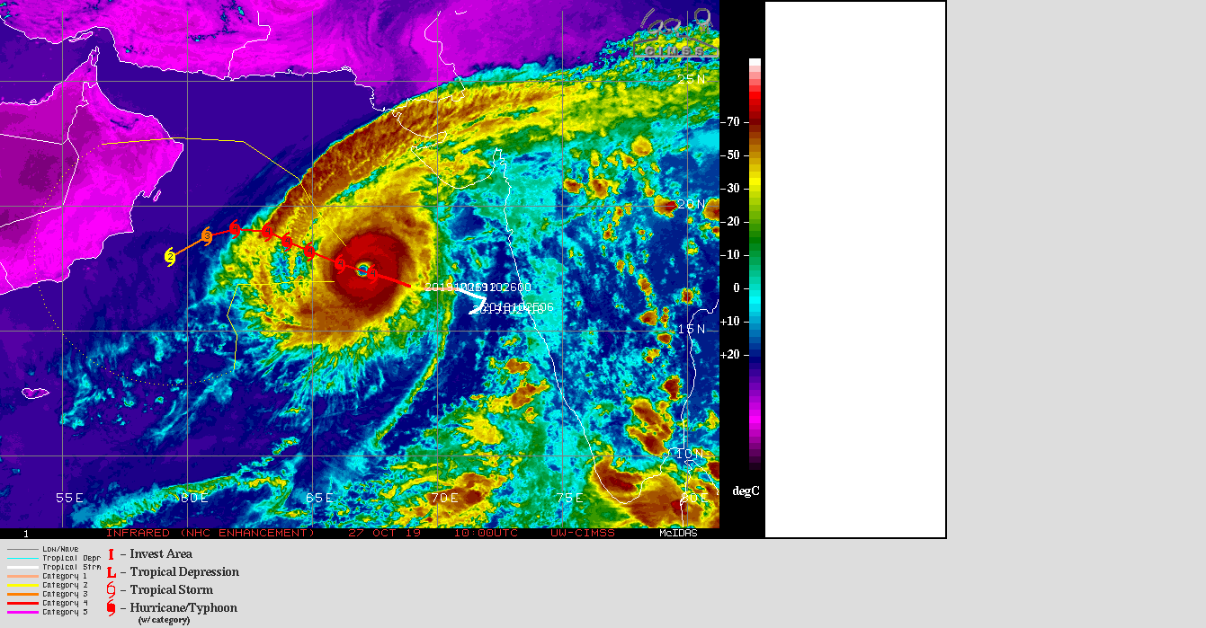
Satellite images indicate persitance of eye pattern with present eye temperature +14.6C and eye diameter is about 50 km. As per the satellite imagery, the current intensity of the system is T6.5. Associated broken low to medium clouds with embedded intense to very intense convection lies over east central Arabian sea between15.5N to 19.0N and 65.0E to 68.5E. The minimum cloud top temperature is -93C.
3 minute sustained winds near the center is 130 knots with gusts of 150 knots. The state of the sea is phenonemal around the center. Estimated central pressure of the super cyclonic storm is 915 hPa.
The Madden-Jullian oscillation lies in the phase 3 with amplitude less than 1. It will remain in the same phase during next 3 days and enter into phase 4 with amplitdue less than 1. Considering the environmental conditions, total precipitable water imageries indicate reduced warm air advection to the system centre. The low level relative vorticity is 300 x10-5 sec-1 to the south of the system centre. The lower level convergence is about 40 x10-5s-1 to the southeast of the system centre and the upper level divergence is about 20 x10-5s-1 around the system centre. The vertical wind shear is low (5 knots) around the system center. Sea surface temperature over most parts of east central Arabian sea is 29-30C and tropical cyclone heat potential is 80 kj/cm2 over the region. Equatorward outflow is taking place in the upper tropospheric levels. All these dynamic and thermodynamic conditions will favour to matain the intensity of a super cylconic storm for next 24 hours. Thereafter, it is likely to move over to colder sea surface temperatures area with lower values of upper ocean heat content. At the same time, cold and dry air intrusion also is likely to take place into the system centre, causing gradual weakening of the system during subsequent 24 hours. Then the system is likely to enter into a zone of high vertical wind shear casuing rapid weakening of the system.
Tropical Cyclone Advisory #25 - 17:30 PM IST October 27 2019
SUPER CYCLONIC STORM KYARR (ARB03-2019)
=========================================
At 12:00 PM UTC, The super cyclonic storm ‘Kyarr’ moved west northwestwards with a speed of 12 km/h during past 6 hours and lays centered near 17.5N 66.7E over east central Arabian sea, about 670 km west southwest of Mumbai (Maharashtra), 1340 km east northeast of Salalah (Oman) and 890 km east southeast of Masirah (Oman).
It is very likely to move west northwestwards towards Oman coast during next 5 days. It is very likely to maintain the intensity of a super cyclonic storm till October 28th and weaken gradually thereafter.
Forecast and Intensity
================
12 HRS: 18.0N 65.6E - 130 knots (Super Cyclonic Storm )
24 HRS: 18.5N 64.6E - 120 knots (Super Cyclonic Storm )
48 HRS: 19.2N 63.1E - 110 knots (Extremely Severe Cyclonic Storm)
72 HRS: 19.5N 62.0E - 90 knots (Extremely Severe Cyclonic Storm)
Satellite images indicate persitance of eye pattern with present eye temperature +14.6C and eye diameter is about 50 km. As per the satellite imagery, the current intensity of the system is T6.5. Associated broken low to medium clouds with embedded intense to very intense convection lies over east central Arabian sea between15.5N to 19.0N and 65.0E to 68.5E. The minimum cloud top temperature is -93C.
3 minute sustained winds near the center is 130 knots with gusts of 150 knots. The state of the sea is phenonemal around the center. Estimated central pressure of the super cyclonic storm is 915 hPa.
The Madden-Jullian oscillation lies in the phase 3 with amplitude less than 1. It will remain in the same phase during next 3 days and enter into phase 4 with amplitdue less than 1. Considering the environmental conditions, total precipitable water imageries indicate reduced warm air advection to the system centre. The low level relative vorticity is 300 x10-5 sec-1 to the south of the system centre. The lower level convergence is about 40 x10-5s-1 to the southeast of the system centre and the upper level divergence is about 20 x10-5s-1 around the system centre. The vertical wind shear is low (5 knots) around the system center. Sea surface temperature over most parts of east central Arabian sea is 29-30C and tropical cyclone heat potential is 80 kj/cm2 over the region. Equatorward outflow is taking place in the upper tropospheric levels. All these dynamic and thermodynamic conditions will favour to matain the intensity of a super cylconic storm for next 24 hours. Thereafter, it is likely to move over to colder sea surface temperatures area with lower values of upper ocean heat content. At the same time, cold and dry air intrusion also is likely to take place into the system centre, causing gradual weakening of the system during subsequent 24 hours. Then the system is likely to enter into a zone of high vertical wind shear casuing rapid weakening of the system.
Partilhar: