Actividade Vulcânica 2017
- Thread starter luismeteo3
- Data de início
-
O novo portal está no ar! Novos meteogramas, cartas, e mais. Mais informações neste tópico
Seguimento Meteorológico: Litoral Norte | Interior Norte e Centro | Litoral Centro | Sul | Açores e Madeira | Livre
Previsões: Curto e médio prazo: até 2 semanas | Longo prazo: mensal e sazonal (Regras e links úteis nos 1ºs posts)
Facebook | Avisos IPMA/Alertas ANEPC
You are using an out of date browser. It may not display this or other websites correctly.
You should upgrade or use an alternative browser.
You should upgrade or use an alternative browser.
- Estado
- Fechado para novas mensagens.


The Weatherman
Cumulus

10.32am: Agung spewing less ash but danger remains
The Head of Bali’s disaster mitigation agency Sutopo Purwo Nugroho has said that Mount Agung is gradually releasing less volcanic ash this morning.
He reported that there was no black or grey ash coming out of the volcano and that continuous seismic activity has reduced. Plumes of white steam are still visible.
However, experts have warned that the threat of eruption remains.
Volcanologist Dr Janine Krippner tweeted: “This does not mean it is over. Fluctuations in activity are a normal part of the life of volcanoes.”
The Weatherman
Cumulus
6pm: Indonesia braces for second cyclone impact
As the residents of Bali continue to live in the shadow of Mount Agung, a new threat is slowly approaching Indoensia.
Indonesia's Meteorology, Climatology and Geophysics Agency (BMKG) issued a warning on Wednesday of a new tropical cyclone barrelling towards the island nation.
Cyclone Dahlia, the second cyclone to pummel Indonesia this month, comes hot on the heels of Cyclone Cempaka which has devastated the southern coast of Java.
The BMKG expects Dahlia to kick up powerful winds of up to 35 knots per hour, and drastically increase increase to 50 knots over the next 24 hours.
“I’ve been doing some Bali simulations with the U.K. Met office climate model as ‘what ifs’, and also some geo-engineering simulations,” said Jim Haywood, professor of atmospheric science at the University of Exeter.
He estimated that Agung spewed eight million tonnes of sulphur dioxide into the stratosphere in 1963, about 10-15 kms above the Earth’s surface, enough to trim world temperatures for months. That eruption killed more than 1,000 people in Bali.
That was impossible, for instance, when Mount Pinatubo in the Philippines erupted in 1991 and blew about 20 million tonnes of sulphur dioxide into the stratosphere, the second biggest eruption of the 20th century after one in Alaska in 1912.
He estimated that the Agung volcano has probably ejected only about 10,000 tonnes of sulphur dioxide in the latest eruption, and not as high as the stratosphere.
Reuters
Como curiosidade, as emissões anuais de CO2 são >35 gigatoneladas.
1 Gigatonelada = 1.000.000.000 toneladas.
8 milhões de toneladas de SO2 arrefecem o planeta. Dezenas de milhares de milhões de toneladas emitidos anualmente de CO2 não têm nenhuma influência?

Última edição:
9.29am: Bali volcano crater filling with lava
The PVMG estimates that one third of Mount Agung’s crater has filled with magma, according to Antara News.
"We calculate it based on the monitoring results of Himawari satellite images of seismic recording data, deformation and geochemistry," said Gede Suantika at the Agung Observation Post in Rendang Village.
He explained that the findings indicate the magma is still very hot and that the volcano is still “in a critical phase”.

1pm: Mount Agung has ‘deflated’ since eruption
The volcano has deflated 3cm since erupting on Saturday, according to Sutopo Purwo Nugroho of Bali disaster mitigation agency (BNPB).
Agung had swelled by at least 4cm in the weeks preceding the eruption.
Sutopo said that volcanologists are now investigating whether “the critical period has passed”
Uma boa notícia...")
The volcano has deflated 3cm since erupting on Saturday, according to Sutopo Purwo Nugroho of Bali disaster mitigation agency (BNPB).
Agung had swelled by at least 4cm in the weeks preceding the eruption.
Sutopo said that volcanologists are now investigating whether “the critical period has passed”
Uma boa notícia...
É impressionante a quantidade de sismos em toda a área de Vatnajokull em vários vulcões incluindo o Öræfajökull...

Is Iceland's tallest volcano, Öræfajökull, awakening?
Co-author:
Dr Dave McGarvie is a Senior Lecturer in the Science, Technology, Engineering and Mathematics Faculty at The Open University.
He is a volcanologist with an international reputation, researching little-known volcanoes in Iceland and Chile, to build knowledge bases that help evaluation of hazards from future eruptions.
Dave McGarvie
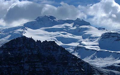
Towering over 2km above coastal plains, Iceland’s highest volcano Öræfajökull is a majestic sight. Its upper half is covered in ice that feeds valley glaciers that can be easily accessed. Tourists and filmmakers love it.
Since June 2017, there have been “swarms” of small earthquakes in the region. Earthquakes are rare at Öræfajökull, so these have prompted meetings between locals, scientists and civil protection authorities.
The unusual activity may indicate a reawakening of Öræfajökull, so it is timely to review previous eruptions and the potential effects of a future eruption.
"Two women and a boy took refuge on the roof … but it was carried away by the deluge of water, and as far as the eye could reach, the three unfortunate persons were seen clinging to the roof. One of the women was afterwards found among the mud of the jökulhlaup [Icelandic term for meltwater flood], but burnt, and as it were parboild; her body was so damaged and tender, but it could scarcely be touched."
This is an eyewitness account of three fatalities during the last eruption (1727) of Öræfajökull. It was a relatively small eruption.
 The previous eruption in 1362, however, remains Iceland’s largest explosive eruption since the island was settled about 1,100 years ago.
This time, thick deposits of pumice and ash (also known as tephra) covered the volcano, while sailors at the time reported pumice floating “in such masses that ships could hardly make their way through it”.
Ash from the 1362 eruption has been found in Greenland and western Europe recently.
We first studied the volcano (pictured above right) in 2001-2002. Our two main findings were that it has a variety of eruption styles and a surprising abundance of lavas known as rhyolites. We know that this can erupt very explosively – as it did in 1362.
To better understand the 1362 eruption, we have also mapped deposits preserved on the volcano.
The main implication of our study is that explosive eruptions at Öræfajökull can be complicated.
The most powerful phase with the highest plume and widest ash dispersal was probably short-lived (lasting from a few hours to a few days), but there were other stages before and after it with varying degrees of explosivity.
Locally, the eruption was devastating. Rich farmland at the foot of the volcano was covered by thick tephra deposits and swept by pyroclastic flows (fast-moving current of hot gas and volcanic matter).
The area was abandoned and renamed “Öræfi” (wasteland). Originally called Hnappafellsjökull, the volcano was renamed Öræfajökull.
Excavations of abandoned farms show buildings had collapsed prior to the tephra fall and, despite evidence of prosperity, virtually nothing valuable was left behind. Also, no corpses were found.
Inhabitants of these farms realised they were in danger, packed their belongings, and left. Large earthquakes then destroyed the buildings before the eruption started.
The Icelandic volcano Eyjafjallajökull erupted in 2010, causing a lot of problems to air travel across Europe.
Would a repeat of the 1362 eruption cause Eyjafjallajökull 2010-style disruption? No.
Its eruption lasted for weeks, with the wind often blowing towards Europe, and aircraft attempted to “avoid all ash”.
.jpg) Since then, improvements to volcanic ash cloud detection and simulation have been made. Revised procedures at the regulators and airlines allow planes to fly where low concentrations of ash may be present.
Since then, improvements to volcanic ash cloud detection and simulation have been made. Revised procedures at the regulators and airlines allow planes to fly where low concentrations of ash may be present.
A repeat of the 1362 eruption would disperse ash widely, but our results suggest this stage would be short-lived.
Other scenarios, like lava erupting beneath the ice, may be longer lasting but any disruption would be more localised.
There are farming communities in the area but these have learned from the 1727 eruption and have relocated their farms from the glacier outlets.
Before the small 1727 eruption, earthquake shocks terrified the people, which suggests that big earthquakes might provide warning of the next eruption and allow time for evacuation.
One of the biggest concerns would be the large number of tourists in the area – especially in summer.
Nearby Skaftafell is Iceland’s seventh most popular tourist destination. However, it lies outside the flood pathways of both the 1362 and 1727 eruptions.
It’s impossible to estimate exactly when Öræfajökull will next erupt. She may just be turning over in her sleep, soon to return to quiet slumber.
Icelandic scientists recently installed additional earthquake monitoring equipment: with their acknowledged expertise in eruption monitoring they will provide the best possible information should Öræfajökull fully awaken.
http://www.open.ac.uk/scotland/news...r&utm_medium=social&utm_campaign=SocialSignIn
Co-author:
Dr Dave McGarvie is a Senior Lecturer in the Science, Technology, Engineering and Mathematics Faculty at The Open University.
He is a volcanologist with an international reputation, researching little-known volcanoes in Iceland and Chile, to build knowledge bases that help evaluation of hazards from future eruptions.
Dave McGarvie
Towering over 2km above coastal plains, Iceland’s highest volcano Öræfajökull is a majestic sight. Its upper half is covered in ice that feeds valley glaciers that can be easily accessed. Tourists and filmmakers love it.
Since June 2017, there have been “swarms” of small earthquakes in the region. Earthquakes are rare at Öræfajökull, so these have prompted meetings between locals, scientists and civil protection authorities.
The unusual activity may indicate a reawakening of Öræfajökull, so it is timely to review previous eruptions and the potential effects of a future eruption.
"Two women and a boy took refuge on the roof … but it was carried away by the deluge of water, and as far as the eye could reach, the three unfortunate persons were seen clinging to the roof. One of the women was afterwards found among the mud of the jökulhlaup [Icelandic term for meltwater flood], but burnt, and as it were parboild; her body was so damaged and tender, but it could scarcely be touched."
This is an eyewitness account of three fatalities during the last eruption (1727) of Öræfajökull. It was a relatively small eruption.
This time, thick deposits of pumice and ash (also known as tephra) covered the volcano, while sailors at the time reported pumice floating “in such masses that ships could hardly make their way through it”.
Ash from the 1362 eruption has been found in Greenland and western Europe recently.
We first studied the volcano (pictured above right) in 2001-2002. Our two main findings were that it has a variety of eruption styles and a surprising abundance of lavas known as rhyolites. We know that this can erupt very explosively – as it did in 1362.
To better understand the 1362 eruption, we have also mapped deposits preserved on the volcano.
The main implication of our study is that explosive eruptions at Öræfajökull can be complicated.
The most powerful phase with the highest plume and widest ash dispersal was probably short-lived (lasting from a few hours to a few days), but there were other stages before and after it with varying degrees of explosivity.
Locally, the eruption was devastating. Rich farmland at the foot of the volcano was covered by thick tephra deposits and swept by pyroclastic flows (fast-moving current of hot gas and volcanic matter).
The area was abandoned and renamed “Öræfi” (wasteland). Originally called Hnappafellsjökull, the volcano was renamed Öræfajökull.
Excavations of abandoned farms show buildings had collapsed prior to the tephra fall and, despite evidence of prosperity, virtually nothing valuable was left behind. Also, no corpses were found.
Inhabitants of these farms realised they were in danger, packed their belongings, and left. Large earthquakes then destroyed the buildings before the eruption started.
The Icelandic volcano Eyjafjallajökull erupted in 2010, causing a lot of problems to air travel across Europe.
Would a repeat of the 1362 eruption cause Eyjafjallajökull 2010-style disruption? No.
Its eruption lasted for weeks, with the wind often blowing towards Europe, and aircraft attempted to “avoid all ash”.
A repeat of the 1362 eruption would disperse ash widely, but our results suggest this stage would be short-lived.
Other scenarios, like lava erupting beneath the ice, may be longer lasting but any disruption would be more localised.
There are farming communities in the area but these have learned from the 1727 eruption and have relocated their farms from the glacier outlets.
Before the small 1727 eruption, earthquake shocks terrified the people, which suggests that big earthquakes might provide warning of the next eruption and allow time for evacuation.
One of the biggest concerns would be the large number of tourists in the area – especially in summer.
Nearby Skaftafell is Iceland’s seventh most popular tourist destination. However, it lies outside the flood pathways of both the 1362 and 1727 eruptions.
It’s impossible to estimate exactly when Öræfajökull will next erupt. She may just be turning over in her sleep, soon to return to quiet slumber.
Icelandic scientists recently installed additional earthquake monitoring equipment: with their acknowledged expertise in eruption monitoring they will provide the best possible information should Öræfajökull fully awaken.
http://www.open.ac.uk/scotland/news...r&utm_medium=social&utm_campaign=SocialSignIn
- Estado
- Fechado para novas mensagens.