Actividade Vulcânica 2017

Estado
Fechado para novas mensagens.
David Cook says:
November 28, 2017 at 13:43
Conductivity in Múlakvísl now soaring to almost 800 and showing no signs of slowing down. I’m surprised this has not been commented on as this is a very high figure and surely suggestive of further geothermal activity in Katla, especially given the time of year and fact it has been below freezing for many days.

Jón Frímann says:
November 28, 2017 at 13:54
The hydrothermal systems in Katla volcano are boiling over and expanding. I don’t understand why this isn’t alarming the scientists monitoring the volcano.

This is the last phase before an eruption in my view. I give it ~3 months at the moment.

http://www.jonfr.com/volcano/?p=7203&cpage=1#comment-74995
 
Not a lahar according to a couple of articles in the Bali Tribune / Giggle translate:

Apparently there is a continuous tremor (overscale) that occurred at 13:30 to 14:00 pm.

Head of Disaster Mitigation Division of Volcanology and Geological Disaster Mitigation Center I Gede Suantika said during the Gunung Agung crisis, the tremor earthquake happened continuously and this phenomenon was the first time.
According to him, conditions that occur indicate Mount Agung entering a critical phase to a larger eruption.
“It has entered a very critical phase for a bigger eruption, as volcanic material is quite large, just this time noting an overscale tremor,” said Suantika.


Precisely on the north side of Mount Agung.

The rain stones shortly after the overscale tremor .
The stone was hot to 500 degrees Celsius.
Hotter than the crater lip.
Head of Mitigation Division of Volcanology and Geological Hazard Mitigation I Gede Suantika, Tuesday (28/11/2017) explains the throwing of stone that begins shortly after the overscale tremor.
“Tremor overscale was indeed followed by a stone throw,” said Suantika.
He also added why the direction of throwing occurred in the Kubu region is more due to the crater of Mount Agung is leaning lower on the north side.
 
CqjPZrN.png

Yani Bolton [7:00 PM]
Someone still keep the old drawing from the old time and its related to their God or their spiritual thing. I saw this new eruption of Agong yesterday, it looks much the same.
 
"What we are seeing at the moment are small explosions, throwing out hot gases and fragments of molten rock, or ash," explained David Pyle, a volcano expert at the University of Oxford in Britain.

Several scientists remarked that Agung's recent behaviour matches the buildup to the devastating 1963 blast that left 1,600 people dead and ejected enough debris—about a billion metric tonnes—to lower global average temperatures a notch (0.2 - 0.3 degrees Celsius) for about a year.

"Based on what we saw in 1963, the present activity is quite similar to the start of that eruption," said Pyle.

"The probability of a large eruption is high, but this may take some days or weeks to unfold."

David Rothery, a professor at The Open University in Britain, also sees a step-change on the horizon.

"The volcano might at last be delivering the large eruption that has been feared for several weeks," he said.

Other scientists were more cautious.

"We are still far from being able to forecast how eruptions are going to develop," said Carmen Solana, a volcanologist at the University of Portsmouth in England. "It could rapidly increase in activity and produce a vast eruption, or it could die down."

PHYS

---

5.33pm: Raging tropical cyclone is shifting Mount Agung’s ash cloud

Indonesian officials said that cyclone Cempaka, located hundreds of miles west of Bali, has begun to affect Agung’s ash emissions.

The churning cyclone pulling in the dangerous ash cloud, out towards the open Indian Ocean.

On top of the erupting volcano, cyclone Cempaka threatens to slam into the Indonesian islands

Cempaka is expected bring in heavy rain, devastating waves and strong winds up to 30 knots per hour for three to four days.

Só podia ser deste jornal -> https://www.express.co.uk/news/worl...Mount-agung-news-live-update-Indonesia-status

O raging tropical cyclone está bastante longe de Bali :facepalm:

k31rS0d.gif


Bali está próximo do equador. Chove muito lá.

Acrescento que o ciclone ainda nem se formou e é ainda pequeno -> http://rammb.cira.colostate.edu/pro...ting_image=2018SH95_4KMIRIMG_201711281500.GIF
 
Última edição:
DPuV1uFV4AAOOzF.jpg


O receio deles tem a ver com as trajectórias coincidentes da nuvem de cinzas e do ciclone. É óbvio que os media se aproveitam destas previsões para fazer notícias sensacionalistas. De qualquer forma se isto acontecesse provavelmente ia tudo parar à Austrália.
 
IM indonésio (WIB = UTC +7):

xyp1aji.png


JTWC:

GLOBAL DYNAMIC MODELS INDICATE THAT 95S WILL REMAIN QUASI-STATIONARY DRIFTING SLOWLY EASTWARD TO SOUTHWARD OVER THE NEXT SEVERAL DAYS. MAXIMUM SUSTAINED SURFACE WINDS ARE ESTIMATED AT 28 TO 33 KNOTS. MINIMUM SEA LEVEL PRESSURE IS ESTIMATED TO BE NEAR 998 MB. BASED ON THE IMPROVING CONVECTIVE SIGNATURE AND FAVORABLE ENVIRONMENTAL CONDITIONS, THE
POTENTIAL FOR THE DEVELOPMENT OF A SIGNIFICANT TROPICAL CYCLONE WITHIN THE NEXT 24 HOURS REMAINS HIGH.

Em termos de registo é uma confusão. Para o IM indonésio já chegou aos 35 nós. O JTWC está na expectativa.

O IM australiano ignora esta perturbação e centra a sua atenção no 96S que está a oeste.
 
10.20am: Map shows ash cloud has changed direction

The latest Darwin Volcanic Ash Advisory Center (VAAC) map for Mount Agung shows volcanic ash has changed direction.

8am: President calls for residents evacuate

President Joko Widodo implored residents living in a zone around Agung deemed at risk to seek refuge in emergency centres.

7.40am: Volcanic ash moves south-southeast

BNPB spokesman Sutopo Purwo Nugroho said: “Volcanic ash spreading of Mount Agung leads to south-southeast. VONA is lowered from RED to ORANGE.”

Bali-volcano-map-1144351.png
VAAC

Bali volcano eruption: Latest ash cloud map
Bali-volcano-eruption-1144335.jpg
AFP Getty

Bali volcano eruption: Picture taken today from Kubu in the Karangasem Regency
7.30am: Plume of ash and smoke hovers above volcano
A large plume of white and grey ash and smoke hovered above Agung on Wednesday, after night-time rain partially obscured a fiery glow at its peak over the last few days.
 
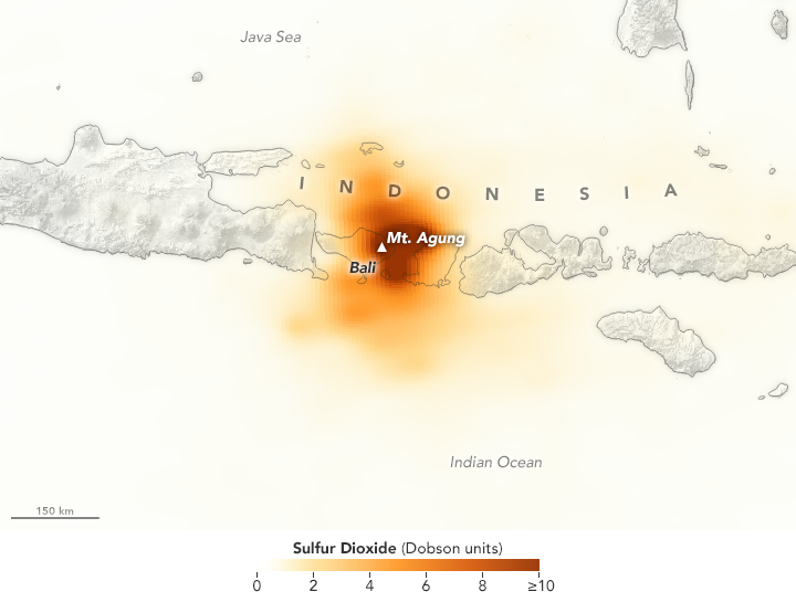
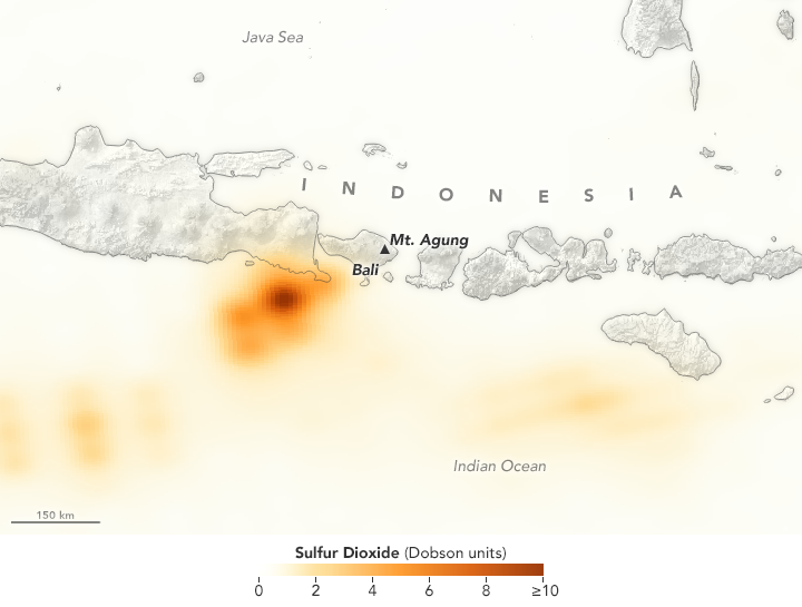
SO2 detectado 27 e 28 de Novembro pelo satélite Ozone Mapper Profiler Suite (OMPS) Suomi National Polar-orbiting Partnership (Suomi-NPP).

agung_omp_2017331.png

agung_omp_2017332.png
 
Última edição:
Estado
Fechado para novas mensagens.