Já não é novidade, mas vão surgindo cada vez mais descobertas utilizando o Google Earth, não só de arqueologia mas também crateras de impacto até aqui desconhecidas. E em Portugal, será que alguém está a a tentar descobrir alguma coisa ?
http://www.cosmosmagazine.com.nyud.net/node/1764Satellites build a picture of the past
Gone are the days of a fearless Indiana Jones battling through the jungle in search of ancient treasures. Today's archaeologists are using high-tech tools - from NASA satellites to Google Earth - to do the hard work for them.
If they haven't been destroyed or dismantled, many ancient structures were long ago enveloped by soil, water, sand, volcanic ash, or thick vegetation. Though they might not be obvious to the naked eye, archaeologists are learning how to spot them.
Since the World War I, aerial photography from low-flying aircraft has been widely used. These images can help to pick out relics betrayed by unusual mounds, lines or disjointed landscapes. In other places, buried structures are completely invisible to the naked eye. But they still reveal clues to their whereabouts - just not with visible light.
The human eye can detect wavelengths of light within the range of around 400 to 700 nanometres. But cameras attached to satellites and aircraft are now taking infrared and ultraviolet shots over a much wider range of wavelengths – and revealing some remarkable details about ancient civilisations.
Mayan cities
When NASA's only archaeologist, Tom Sever, looked at an infrared satellite image of a Mayan city in Guatemala, he was intrigued to see the vegetation around the buildings showed up as much brighter than the vegetation in other areas. Following a hunch, Sever, based at the Marshall Space Flight Centre in Hunstville, Alabama, looked for other patches of bright vegetation on the U.S. space agency's maps.
Sure enough, he found additional bright spots at sites not previously considered for archaeological digs.
Sever hypothesised that the limestone that the Maya used for building had leeched into the soil, altering vegetation at these sites. Since chlorophyll in plants glows brightly in the infrared range, NASA's satellites were able to pick up the subtle difference in vegetation. With this new method in their toolkit, archaeologists went on to discover several previously unknown Mayan cities.
Spotting entire new cities is one thing, but these images can also provide intricate data about already well-known sites.
Payson Sheets, a professor of archaeology at the University of Colorado, has directed the Arenal Research Project in northwestern Costa Rica since the 1980s. He has used similar infrared images from NASA satellites and aircraft to solve a long-standing mystery.
An answer from the skies
His work revolved around the ancient village of Cañales, settled around 2000 BC in the Arenal area of Costa Rica. The village was abandoned several times after volcanic eruptions. However, after every eruption the village was reoccupied once again. The question of who was reoccupying the village was perplexing: were they the original villagers or new people taking advantage of a prime location?
The answer came from above. Infrared images revealed faint lines stretching between Cañales and a cemetery around 11 km away. When Sheets arrived on the site, he found ancient footpaths – the oldest footpaths known. These had changed the soil texture, and hence vegetation, which showed up as the faint line in the infrared image.
The footpaths were deeply entrenched and found around many of the villages in the area. Sheets argues that they were part of a spiritual ritual for the ancient culture; after excavations, he realised they had been used continually – even after devastating volcanic eruptions.
"The path from the Cañales village to the cemetery was in use over a period of some 800 years, or possibly as long as 1,100 years, interrupted twice by natural disasters from Arenal volcano," he said. "The dominating reason for relocation probably was to re-establish contact with the spirits of their deceased ancestors in their distant cemetery."
Thermal clues
It is not always changes in vegetation that reveals a hidden structure. Every object in the universe continually emits electromagnetic waves, such as light and infrared. The wavelengths emitted depend on the material and the temperature of the object.
Sensitive detectors, on satellites or aircraft, can reveal slight differences in ground cover through tiny variations in temperature. So if a region contains more stone, water or wood than its surrounds, it will stand out in a multi-spectral image.
In August 2007, an international team of researchers used these methods to peel back the ground cover in Cambodia and reveal intricate waterworks around the famous temples of Angkor Wat, the capital of the Khmer empire that flourished between in the 9th and 14th centuries.
As well as iconic temples, Angkor has canals and reservoirs interspersed with small local temples, mounded areas, and ponds. Erosion, breaches in dykes, and evidence of ancient flooding suggest the inhabitants of Angkor were unable to maintain their vast irrigation system.
Archaeologists now suspect the demise of this massive settlement was environmental pressure due to overpopulation and deforestation.
Major expense
Over the last 20 years or so, these multi-spectral images from satellites and aircraft have revealed intricate details and hidden treasures from many more ancient cultures. "I can not imagine doing regional archaeology without good imagery from aircraft and satellites now," said Sheets.
Unfortunately though, this data can be prohibitively expensive. Images from NASA, or from commercial satellites like DigitalGlobe's QuickBird or GeoEye's IKONOS, can cost tens of thousands of dollars each.
In 2005 the Internet search company Google launched its virtual globe – Google Earth – constructed from satellite images and aerial photography. The program quickly caught on with millions of users around the world keen to zoom in on their houses, their dream holiday destinations, and even unintentional pictures of boats and planes.
But then, as the story goes, an Italian computer programmer, Luca Mori, turned its use to archaeology. Using Google Earth, he found signs of a Roman villa buried beneath a riverbed. He contacted experts, who decided to excavate.
American archaeologist Scott Madry, Associate Professor at the University of North Carolina at Chapel Hill, stumbled across a newspaper covering Mori's story. Madry had been professionally surveying archaeological sites for more than 25 years, becoming frustrated with the inefficient, dangerous and somewhat inaccurate method of aerial surveying.
Google it
Within a few hours on Google Earth, Madry was able to locate 101 features in an area covering 1,440 square kilometres in Central France. These features represented Iron Age, Medieval and Gallo-Roman sites.
"I have found a very large number of sites using Google Earth from my office here in the U.S.. I was quite surprised at this, and have now given many different short courses in the U.S. and Europe for archaeologists on how to use Google Earth in their work," Madry said.
"Now, with the commercial ultra-high resolution satellite imagery and especially with Google Earth, archaeologists can conduct regional site surveys from their own offices," Madry said. "This is something we would have only dreamed of before."
All of this does make you wonder: what will happen to the quintessential, khaki-clad archaeologist pictured in countless movies and novels? Will popular culture embrace a relic hunter who looks more like Bill Gates than Harrison Ford or Angelina Jolie? At the rate technology is improving, it won't be long before we find out.
http://www.astroseti.org/impactos.phpComo descubrir impactos de asteroides
La historia real del descubrimiento de dos cráteres de impacto
Por Emilio González
Nota : Ahora que todo el mundo esta informando de estructuras, por favor, independientemente de usar NASA World Wind, Google Maps, Google Earth, etc., si crees que has descubierto algo utiliza Google Earth (descárgalo si todavía no está instalado en tu PC) y activa la capa de Google Earth Community layer. Este es el primer paso para ver si alguien más ha detectado esa estructura antes. Después NASA World Wind es genial para verificar. Con sus didferentes capas quizás puedas apreciar más detalles y la vista 3D ayuda mucho. No molestes a los geólocos con cada cosa que parezca un círculo
En este artículo encontrarán la historia paso a paso del descubrimiento de dos cráteres candidatos a ser el resultado del impacto de asteroides contra nuestro planeta, y como además pueden ayudar a verificar una teoría de una geóloga de la NASA.
El 6 de Marzo anunciamos el descubrimiento de un cráter de impacto en Kebira, Egipto, cerca de la frontera con Libia, de 31 km de diámetro por parte de investigadores de la Universidad de Boston.
EL día 8, utilizando el programa Google Earth decidí comprobar como se vería este cráter, pues las imágenes por satélite que ofrece este programa varían en calidad de un lugar a otro. Lo lógico habría sido pensar que su figura sería difícil de distinguir y que por ello no había sido descubierto hasta el momento, pero siguiendo la descripción del artículo me dirigí a la frontera entre Egipto y Siria, y en menos de un minuto localicé perfectamente la figura del cráter.
El impacto de Kebira
El cráter Kebira desde 30 km de altura
La pregunta que surgió de inmediato fue ¿Y nadie se había dado cuenta antes? ¿Cómo puede una estructura como esa, de 31 kilómetros, pasar desapercibida? Así que me propuse explorar un poco los alrededores por si hubiera otras estructuras similares.
Justo había pasado ya Libia y entraba en Chad cuando desde una altura de 121 millas otra estructura claramente circular apareció en mi pantalla. Una vista más cercana mostraba una estructura aparentemente típica de un impacto, no volcánica. Localizar un cráter de impacto no tenía ningún mérito si este ya era conocido, así que debía comprobarlo y visité la lista de cráteres de impactos de la Universidad de Brunswick, en Canadá, sin que coincidiera con ninguno de los conocidos.
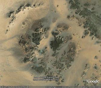
Primer cráter de impacto candidato
El primer cráter visto desde 20km de altura
Decidí volver a las alturas y en pocos segundos una mancha sospechosa a apenas 50km de distancia del cráter anterior llamó mi atención. Me acerqué y enseguida me di cuenta de que a primera vista las características coincidían nuevamente con las de un cráter de impacto. Este cráter tampoco figuraba en la lista de la Universidad de Brunswick. No podía ser tan fácil. ¿No estaría sufriendo un estado de excitación que me haría ver cráteres de impacto por todas partes?
Busqué más información en Internet, encontrando otra web http://www.impact-structures.com dirigida por dos geólogos, Kord Ernston de la Universidad de Würzsburg y el español Fernando Claudín, del Museo de Geología de Barcelona, y enlazaban con una base de datos más actualizada que la canadiense y envié las imágenes en espera de algún comentario.
La respuesta de Fernando Claudín fue casi inmediata. Según el geólogo "la circularidad por si sola no es un criterio que baste para identificar una estructura como de impacto", si bien en el primer cráter observa "un anillo externo cuyas capas parecen inclinadas hacia el exterior (buzamiento radial a partir del centro de la estructura), y un anillo interno o levantamiento central" Y finalmente concluye "No me parece una estructura volcánica"
Respecto al segundo cráter comenta que "menos marcado que el anterior, también me parece apreciar dos anillos, uno externo y uno interno, en este caso surcados por caminos (lo que en principio es bueno ya que significa, a priori, afloramientos). La zona central parece deprimida (delimitada por el anillo interno)"
El problema para realizar la confirmación es básicamente económico: Es necesario que acudan los geólogos al lugar para comprobar si existen "brechas, diques de brechas, conos astillados, metamorfismo de impacto, etc."
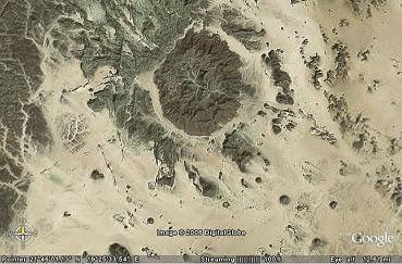
Segundo cráter de impacto candidato

El segundo cráter desde unos 5000 metros de altura
Lo mejor para mi estabilidad emocional fue sin duda que según Claudín "no parece que estés afectado por la fiebre de impactos. Hay base más que suficiente para empezar a investigar".
Así pues tenemos dos cráteres que, tienen todo el aspecto de haber sido causados por impactos de asteroides, pero necesitan de una visita para obtener la confirmación.
Los dos cráters de impacto

Estaban bastante cerca el uno del otro
Debía de haber un error en alguna parte. A pesar de todas las precauciones que había tomado no podía creerme que yo hubiera sido el primero en ver esas dos estructuras tan claras, así que quisé localizar más información sobre cráteres de impacto en Chad. Tras poner las palabras -en inglés- en el buscador aparecía el cráter de Aorounga, un cráter que naturalmente figuraba en las bases de datos que había consultado. Lo curioso fue que encontré un artículo sobre Adriana Ocampo, una investigadora del JPL de la NASA que mediante imágenes de radar había detectado varios impactos más junto a Aorounga, que era necesario confirmar. ¿Sería posible que mis cráteres formaran parte de esa cadena? Nuevamente abrí el programa me dirigí a Aorounga y elevé la vista lo suficiente como para que todos los cráteres aparecieran en la pantalla, pues hay 300km de distancia entre ellos ... y ¡ Todos estaban en línea!
Dejé pasar un tiempo esperando más confirmaciones. No quería publicar algo que después resultara un fiasco. Pero los canadienses no respondían a mis mensajes. Fernando Claudín quería que Kord Ernstson también diera también su opinión, así que esperé (im)pacientemente hasta que su opinión llegó "¡ Felicidades ! Las estructuras que has descubierto son muy prometedoras!". Según Kord "el que haya dos cráteres más en la línea de Aorounga es fantástico", algo parecido al la línea de impactos que están estudiando en Azuara, entre Teruel y Zaragoza.
Finalmente recibí un email de Jason Hines, Data Manager de la Base de Datos de Estructuras de Impacto de la Universidad de Brunswick. "Parece que has encontrado unas estructura de impacto candidatas", dice, pero insiste "tomar muestras del lugar de indicios de impacto es el mejor método de confirmar el origen de un impacto".
La historia continúa. En estos momentos sigo esperando respuestas de los canadienses, de David Morrison (reponsable de la web de la NASA http://impact.arc.nasa.gov) y de Adriana Ocampo, a quien el descubrimiento de estos cráteres podría ayudar a confirmar su teoría si todos los cráteres tuvieran la misma datación.
Lo más importante de esta historia probablemente sea el que gracias a un software de distribución gratuita es posible para cualquiera realizar una búsqueda de estructuras semejantes. Probablemente tuve suerte, ya que después de este éxito inicial he pasado horas recorriendo África sin resultado.
De cualquier forma, si se decide a buscar cráteres de impacto, asegúrese de no confundirlos con volcanes, compruebe las listas de impactos ya conocidos, o posibles candidatos y entonces, sólo entonces: ¡consulte con su geólogo!
Buena caza.
")
