luismeteo3
Furacão
 Este tipo é demais! Era fabuloso para stand up comedy... pena ser presidente dos Estados Unidos da América... Este tipo é demais! Era fabuloso para stand up comedy... pena ser presidente dos Estados Unidos da América...
Ainda melhor, é um furacão baptizado de "Olhão" e passar o olho do furacão, por aqui. Nesse caso, fazia todo sentido "Olhão" significa grande olho com um furacão via-se o grande olho literalmente.
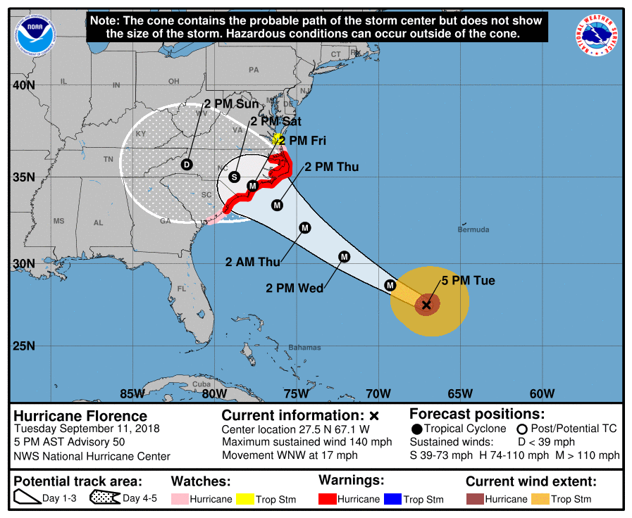
Florence, vai dar muito que falar nos próximos dias.
 “tremendous big and tremendous wet” a mais épica declaração de sempre... cada um que pense o que quiser lololol
Enviado do meu iPhone usando o Tapatalk
 para os três posts acima...


FORECAST POSITIONS AND MAX WINDS
INIT 11/2100Z 27.5N 67.1W 120 KT 140 MPH
12H 12/0600Z 28.7N 69.3W 130 KT 150 MPH
24H 12/1800Z 30.4N 72.1W 135 KT 155 MPH
36H 13/0600Z 32.1N 74.5W 130 KT 150 MPH
48H 13/1800Z 33.4N 76.2W 120 KT 140 MPH
72H 14/1800Z 34.5N 77.7W 100 KT 115 MPH...NEAR THE COAST
96H 15/1800Z 35.0N 78.8W 40 KT 45 MPH...INLAND
120H 16/1800Z 35.7N 81.7W 25 KT 30 MPH...INLAND
SUMMARY OF WATCHES AND WARNINGS IN EFFECT:
A Storm Surge Warning is in effect for...
* South Santee River South Carolina to Duck North Carolina
* Albemarle and Pamlico Sounds, including the Neuse and Pamlico
Rivers
A Storm Surge Watch is in effect for...
* Edisto Beach South Carolina to South Santee River South Carolina
* North of Duck North Carolina to the North Carolina/Virginia border
A Hurricane Warning is in effect for...
* South Santee River South Carolina to Duck North Carolina
* Albemarle and Pamlico Sounds
A Hurricane Watch is in effect for...
* Edisto Beach South Carolina to South Santee River South Carolina
* North of Duck North Carolina to the North Carolina/Virginia border
A Tropical Storm Watch is in effect for...
* North of the North Carolina/Virginia border to Cape Charles Light
Virginia
* Chesapeake Bay south of New Point Comfort
Interests elsewhere in the southeastern and mid-Atlantic states
should monitor the progress of Florence. Additional watches and
warnings may be required tonight or Wednesday.
HAZARDS AFFECTING LAND
----------------------
STORM SURGE: The combination of a dangerous storm surge and the
tide will cause normally dry areas near the coast to be flooded by
rising waters moving inland from the shoreline. The water has the
potential to reach the following heights above ground if peak surge
occurs at the time of high tide...
Cape Fear to Cape Lookout, including the Neuse and Pamlico
Rivers...9-13 ft
North Myrtle Beach to Cape Fear...6-9 ft
Cape Lookout to Ocracoke Inlet...6-9 ft
South Santee River to North Myrtle Beach...4-6 ft
Ocracoke Inlet to North Carolina/Virginia Border...4-6 ft
Edisto Beach to South Santee River...2-4 ft
The deepest water will occur along the immediate coast in areas of
onshore winds, where the surge will be accompanied by large and
destructive waves. Surge-related flooding depends on the relative
timing of the surge and the tidal cycle, and can vary greatly over
short distances. For information specific to your area, please see
products issued by your local National Weather Service forecast
office.
RAINFALL: Florence is expected to produce total rainfall
accumulations of 15 to 25 inches with isolated maximum amounts of
35 inches near the storm's track over portions of the Carolinas and
Mid-Atlantic States from late this week into early next week. This
rainfall would produce catastrophic flash flooding and significant
river flooding.
WIND: Hurricane conditions are expected to reach the coast within
the hurricane warning area on Friday. Winds are expected to first
reach tropical storm strength on Thursday, making outside
preparations difficult or dangerous. Preparations to protect life
and property should be rushed to completion.
SURF: Swells generated by Florence are affecting Bermuda and
portions of the U.S. East Coast. These swells are likely to cause
life-threatening surf and rip current conditions. Please consult
products from your local weather office.


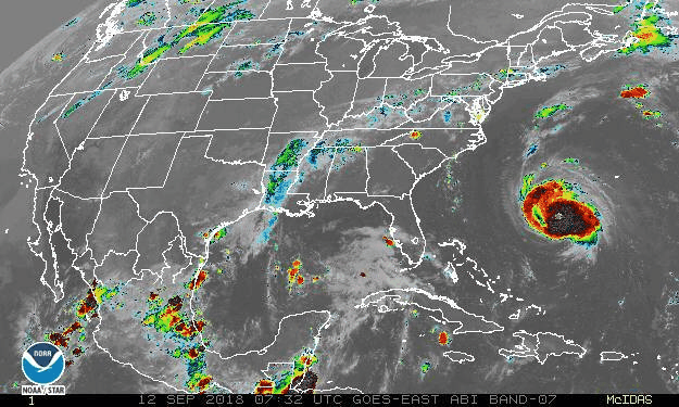
Já chove com bastante intensidade na costa da Carolina do Norte.
Carolina beach há minutos:
")
A chuva que está a cair ainda não é do Florence, ainda está muito longe da costa!