Furacão FLORENCE (Atlântico 2018 #AL06)

luismeteo3

Furacão
Registo
14 Dez 2015
Mensagens
17,112
Local
Fatima (320m)
500
WTNT31 KNHC 130547
TCPAT1

BULLETIN
Hurricane Florence Intermediate Advisory Number 55A
NWS National Hurricane Center Miami FL AL062018
200 AM EDT Thu Sep 13 2018

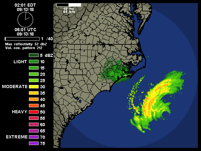
...FLORENCE MOVING CLOSER TO THE COAST OF NORTH AND SOUTH
CAROLINA...
...LIFE-THREATENING STORM SURGE AND RAINFALL STILL EXPECTED...


SUMMARY OF 200 AM EDT...0600 UTC...INFORMATION
----------------------------------------------
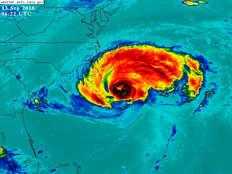
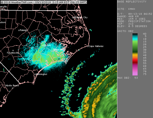
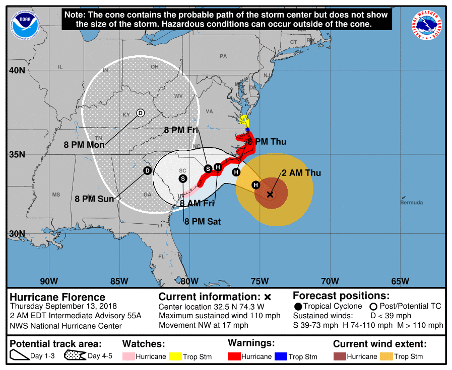
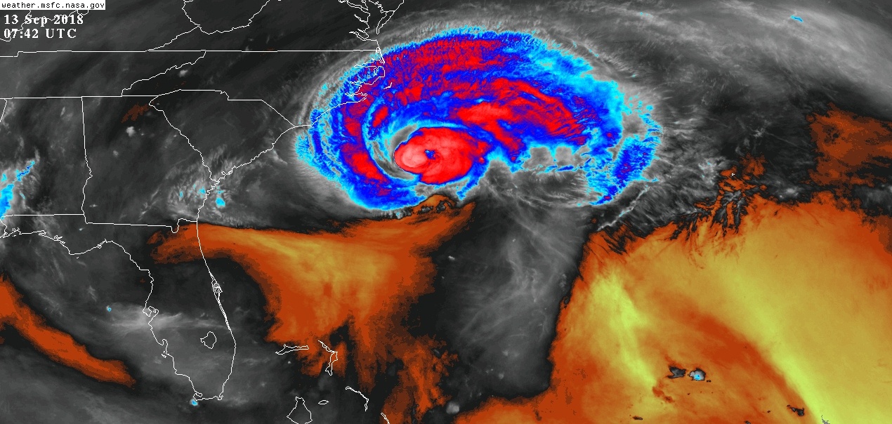
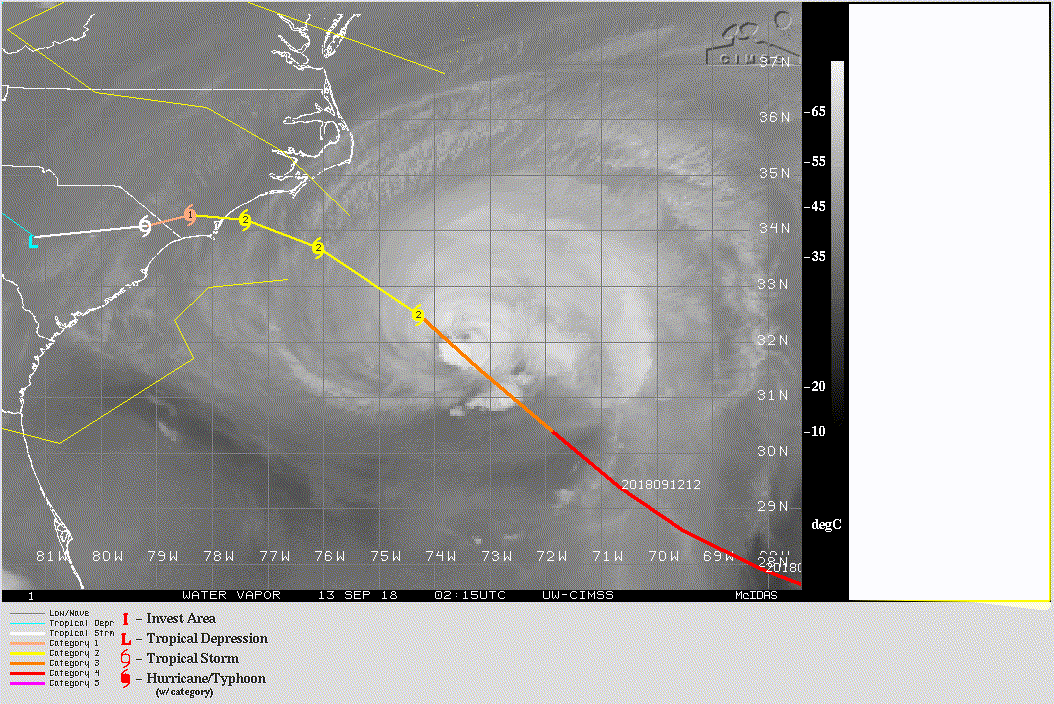
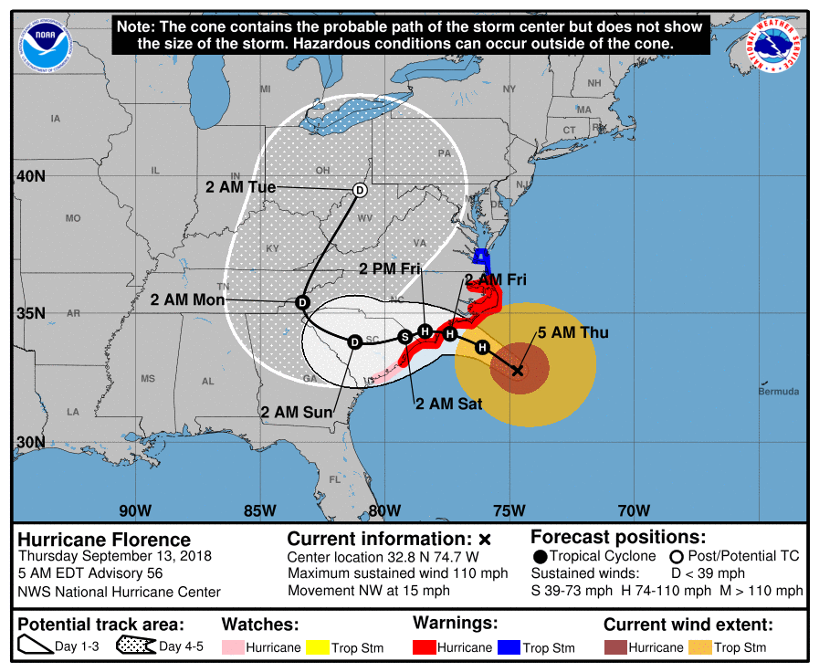
LOCATION...32.5N 74.3W
ABOUT 235 MI...375 KM ESE OF WILMINGTON NORTH CAROLINA
ABOUT 280 MI...450 KM ESE OF MYRTLE BEACH SOUTH CAROLINA
MAXIMUM SUSTAINED WINDS...110 MPH...175 KM/H
PRESENT MOVEMENT...NW OR 315 DEGREES AT 17 MPH...28 KM/H
MINIMUM CENTRAL PRESSURE...956 MB...28.23 INCHES
 
  • Gosto
Reactions: Afgdr


luismeteo3

Furacão
Registo
14 Dez 2015
Mensagens
17,112
Local
Fatima (320m)
rbtop_lalo-animated.gif
 

Orion

Furacão
Registo
5 Jul 2011
Mensagens
21,648
Local
Açores
This, combined with sea surface temperatures near 29C, would allow a last chance for strengthening before landfall. However, the storm structure, particularly the large outer wind maxima, would likely be slow to respond to the more favorable environment.

FORECAST POSITIONS AND MAX WINDS

INIT 13/0300Z 32.0N 73.7W 95 KT 110 MPH
12H 13/1200Z 33.1N 75.3W 95 KT 110 MPH
24H 14/0000Z 33.9N 76.7W 95 KT 110 MPH
36H 14/1200Z 34.2N 78.0W 80 KT 90 MPH...INLAND
48H 15/0000Z 34.1N 78.7W 60 KT 70 MPH...INLAND

Por acaso um Cat. 3 fraco é/seria bem mais tolerável.

Resta saber que intensidade pode voltar a adquirir nas próximas horas.
 
Última edição:

Orion

Furacão
Registo
5 Jul 2011
Mensagens
21,648
Local
Açores
The global models suggest that this shear will relax today while Florence moves over warm waters, however, given the current storm structure, little overall change in strength is anticipated as Florence approaches the coast. Gradual weakening should occur as the hurricane interacts with land in 24-36 h, with a faster rate of weakening predicted once Florence moves farther inland.

Although there is still some spread in the guidance by 48 hours, with the GFS along the northern side of the guidance envelope, and the ECWMF along the southern edge, the various consensus aids have moved little.

FORECAST POSITIONS AND MAX WINDS

INIT 13/0900Z 32.8N 74.7W 95 KT 110 MPH
12H 13/1800Z 33.7N 76.1W 95 KT 110 MPH
24H 14/0600Z 34.2N 77.4W 90 KT 105 MPH
36H 14/1800Z 34.3N 78.4W 70 KT 80 MPH...INLAND

Previsão bastante favorável, podendo chegar como cat. 2 à costa (se bem que 5 nós não fazem grande diferença). Ainda assim, o ondulação e a precipitação vão causar (muitos?) danos.
 

luismeteo3

Furacão
Registo
14 Dez 2015
Mensagens
17,112
Local
Fatima (320m)
From NHC 5 a.m. Florence Discussion:
Key Messages:
1. A life-threatening storm surge is now highly likely along
portions of the coastlines of South Carolina and North Carolina, and
a Storm Surge Warning is in effect for a portion of this area. All
interests in these areas should complete preparations and follow any
advice given by local officials.
2. Life-threatening, catastrophic flash flooding and prolonged
significant river flooding are likely over portions of the Carolinas
and the southern and central Appalachians late this week into early
next week, as Florence is expected to slow down as it approaches the
coast and moves inland.
3. Damaging hurricane-force winds are likely along portions of the
coasts of South Carolina and North Carolina, and a Hurricane Warning
is in effect. Strong winds could also spread inland into portions
of the Carolinas.
4. Large swells affecting Bermuda, portions of the U.S. East
Coast, and the northwestern and central Bahamas will continue this
week, resulting in life-threatening surf and rip currents.

FORECAST POSITIONS AND MAX WINDS
INIT 13/0900Z 32.8N 74.7W 95 KT 110 MPH
12H 13/1800Z 33.7N 76.1W 95 KT 110 MPH
24H 14/0600Z 34.2N 77.4W 90 KT 105 MPH
36H 14/1800Z 34.3N 78.4W 70 KT 80 MPH...INLAND
48H 15/0600Z 34.1N 79.2W 50 KT 60 MPH...INLAND
72H 16/0600Z 33.9N 81.2W 30 KT 35 MPH...INLAND
96H 17/0600Z 35.4N 83.3W 25 KT 30 MPH...INLAND
120H 18/0600Z 39.5N 81.0W 20 KT 25 MPH...POST-TROP/REMNT LOW
$$
Forecaster Brown
 
  • Gosto
Reactions: Afgdr