Furacão Irma
- Thread starter Orion
- Data de início
-
O novo portal está no ar! Novos meteogramas, cartas, e mais. Mais informações neste tópico
Seguimento Meteorológico: Litoral Norte | Interior Norte e Centro | Litoral Centro | Sul | Açores e Madeira | Livre
Previsões: Curto e médio prazo: até 2 semanas | Longo prazo: mensal e sazonal (Regras e links úteis nos 1ºs posts)
Facebook | Avisos IPMA/Alertas ANEPC
You are using an out of date browser. It may not display this or other websites correctly.
You should upgrade or use an alternative browser.
You should upgrade or use an alternative browser.

Snifa
Furacão
Furacão Irma deixa duas ilhas praticamente destruídas
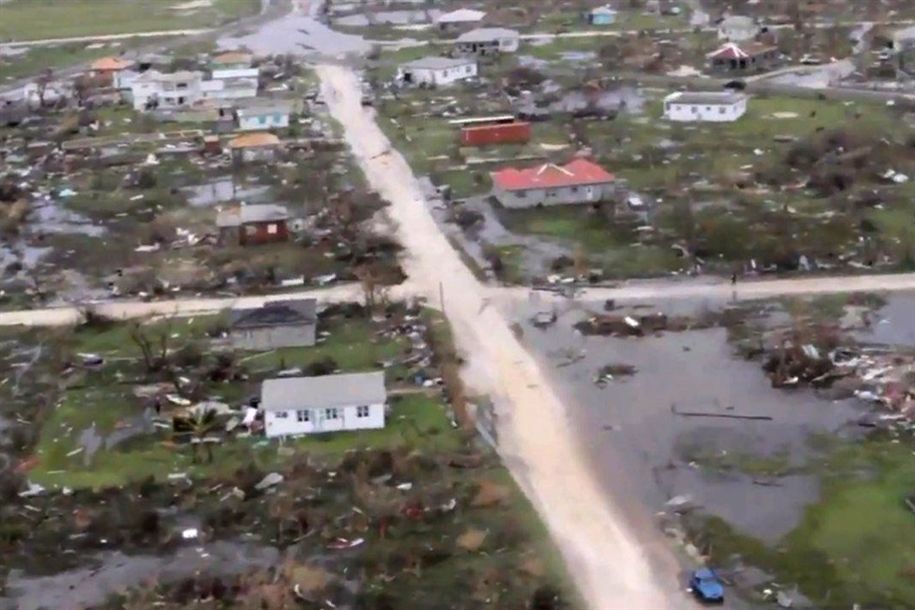
O furacão Irma atingiu as Caraíbas, deixando a ilha de Barbuda "totalmente devastada" e 95% da parte francesa de Saint-Martin, nas Antilhas Pequenas, destruída.
A pequena ilha de Barbuda, nas Caraíbas, foi "totalmente devastada" pela passagem do Irma, que causou a morte de uma pessoa, segundo o primeiro-ministro de Antígua e Barbuda, Gaston Browne.
"Por enquanto temos apenas registo de uma morte", disse Browne. No entanto, o furacão de categoria 5 causou a destruição da ilha que tem 1600 habitantes, que agora "não é mais que um monte de destroços".
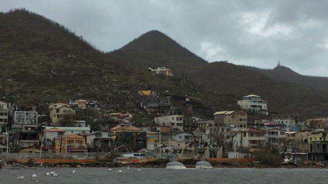
Também nas Caraíbas, a parte francesa da ilha franco-holandesa Saint-Martin ficou "95% destruída" com a passagem do Irma, disse na quarta-feira à noite o presidente do conselho territorial local, Daniel Gibbs.
"É uma catástrofe enorme. 95% da ilha está destruída. Estou em choque. É uma loucura", declarou ao telefone com a Rádio Caraíbas Internacional.
O prefeito do departamento de Guadeloupe, Eric Maire, já tinha informado que há registo de pelo menos seis mortos em Saint-Martin.
http://www.jn.pt/mundo/interior/furacao-irma-deixa-duas-ilhas-praticamente-destruidas-8753495.html
O furacão Irma atingiu as Caraíbas, deixando a ilha de Barbuda "totalmente devastada" e 95% da parte francesa de Saint-Martin, nas Antilhas Pequenas, destruída.
A pequena ilha de Barbuda, nas Caraíbas, foi "totalmente devastada" pela passagem do Irma, que causou a morte de uma pessoa, segundo o primeiro-ministro de Antígua e Barbuda, Gaston Browne.
"Por enquanto temos apenas registo de uma morte", disse Browne. No entanto, o furacão de categoria 5 causou a destruição da ilha que tem 1600 habitantes, que agora "não é mais que um monte de destroços".
Também nas Caraíbas, a parte francesa da ilha franco-holandesa Saint-Martin ficou "95% destruída" com a passagem do Irma, disse na quarta-feira à noite o presidente do conselho territorial local, Daniel Gibbs.
"É uma catástrofe enorme. 95% da ilha está destruída. Estou em choque. É uma loucura", declarou ao telefone com a Rádio Caraíbas Internacional.
O prefeito do departamento de Guadeloupe, Eric Maire, já tinha informado que há registo de pelo menos seis mortos em Saint-Martin.
http://www.jn.pt/mundo/interior/furacao-irma-deixa-duas-ilhas-praticamente-destruidas-8753495.html
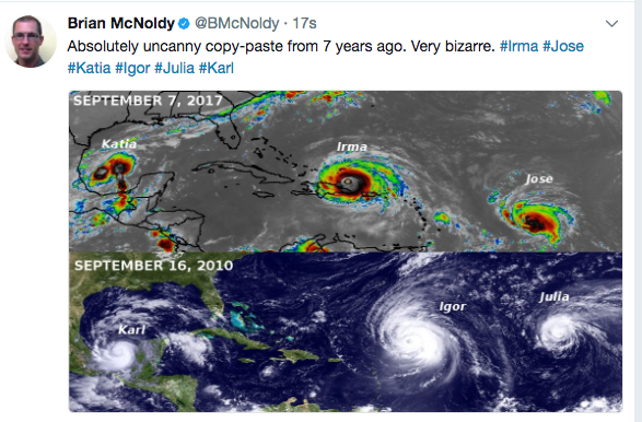
o ciclone Irma é a tempestade perfeita... isto vai ser uma catástrofe.
O amasso nas pequenas ilhas é enorme, não se vê muita destruição porque são ilhas pouco habitadas... nas grandes metrópoles da florida vai ser diferente.
O amasso nas pequenas ilhas é enorme, não se vê muita destruição porque são ilhas pouco habitadas... nas grandes metrópoles da florida vai ser diferente.
Muito embora se creia que a passagem por Cuba possa "amansar" o bicho, a verdade é que, se as previsões de temperatura da água se mantiverem, provavelmente o que perder na passagem por Cuba vai ganhar até atingir a Florida (principalmente o arquipélago Florida Keys).

luismeteo3
Furacão
luismeteo3
Furacão
luismeteo3
Furacão
Toby
Cumulonimbus
Bom dia,
https://www.nrlmry.navy.mil/nexsat-...goes&&buttonPressed=Animate&ANIM_TYPE=Instant
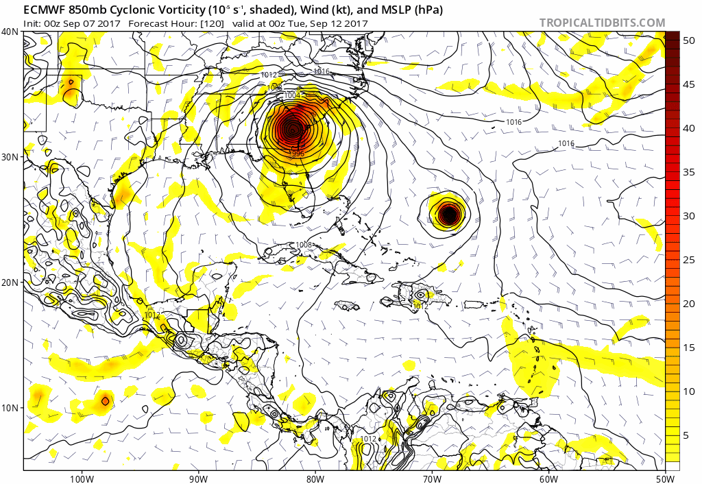
Cenário possível

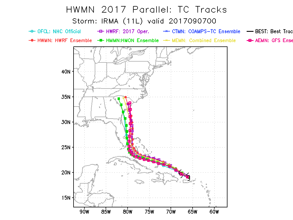
Hurricane Irma Discussion Number 33
NWS National Hurricane Center Miami FL AL112017
500 AM AST Thu Sep 07 2017
Irma has become a little less organized during the past few hours.
Data from an Air Force reserve Hurricane Hunter aircraft near 0500
UTC indicated that the central pressure had risen to 921 mb and
that the winds had decreased both at the 700 mb flight-level and in
surface estimates from the Stepped Frequency Microwave Radiometer.
Since that time, the eye has become cloud filled and the central
convection has become somewhat ragged. The initial intensity is
lowered to 155 kt, and this could be a little generous. The next
aircraft is scheduled to reach Irma around 1200 UTC.
The initial motion is 290/15. The hurricane is currently being
steered by the subtropical ridge to the north, and for the next
48 h or so this motion is expected to continue with a decrease in
the forward speed. After 48 h, a mid- to upper-level trough
digging into the eastern United States is expected to create a
break in the ridge and allow Irma to turn northward. The timing of
the turn is the most important question and one still filled with
uncertainty. The UKMET, UK Ensemble mean, and the NAVGEM are the
models showing the latest turn, and they forecast Irma to move into
the southeastern Gulf of Mexico and near the west coast of the
Florida Peninsula. The ECMWF and ECMWF Ensemble mean are in the
middle of the model pack and show Irma moving over the southeastern
portion of the Florida Peninsula. The GFS, Canadian, and GFS
Ensemble mean show the earliest turn and show Irma moving east of
the coast of Florida toward the southeastern United States. The
new forecast track will best follow the ECMWF, as well as the
Florida State Superensemble and the HFIP Corrected Consensus, and
it calls for the center to move over portions of the southeastern
Florida Peninsula between 72-96 h and then across the Atlantic into
southern South Carolina by 120 h. Users are again reminded not to
focus on the exact track since the average NHC track errors at days
3, 4, and 5 are about 120, 175, and 225 miles, respectively.
Irma should remain in warm-water, and a low shear environment for
about the next three days, and thus is expected to remain a strong
hurricane, most likely Category 5 or 4. Fluctuations in intensity
are likely during the time due to internal eyewall replacement
cycles. The large-scale models suggest that shear could increase
starting at about 72 hr. However, due to the uncertainty as to
whether this will happen, the intensity forecast keeps Irma at
category 4 strength until landfall in Florida. The 96-120 h points
now have a lower intensity due to the forecast of shear and land
interaction, but Irma is still expected to be a hurricane when it
reaches the southeastern United States.
Since Irma is moving away from Puerto Rico and the radars there, the
hourly position estimates are discontinued after this advisory.
https://www.nrlmry.navy.mil/nexsat-...goes&&buttonPressed=Animate&ANIM_TYPE=Instant
Cenário possível
Hurricane Irma Discussion Number 33
NWS National Hurricane Center Miami FL AL112017
500 AM AST Thu Sep 07 2017
Irma has become a little less organized during the past few hours.
Data from an Air Force reserve Hurricane Hunter aircraft near 0500
UTC indicated that the central pressure had risen to 921 mb and
that the winds had decreased both at the 700 mb flight-level and in
surface estimates from the Stepped Frequency Microwave Radiometer.
Since that time, the eye has become cloud filled and the central
convection has become somewhat ragged. The initial intensity is
lowered to 155 kt, and this could be a little generous. The next
aircraft is scheduled to reach Irma around 1200 UTC.
The initial motion is 290/15. The hurricane is currently being
steered by the subtropical ridge to the north, and for the next
48 h or so this motion is expected to continue with a decrease in
the forward speed. After 48 h, a mid- to upper-level trough
digging into the eastern United States is expected to create a
break in the ridge and allow Irma to turn northward. The timing of
the turn is the most important question and one still filled with
uncertainty. The UKMET, UK Ensemble mean, and the NAVGEM are the
models showing the latest turn, and they forecast Irma to move into
the southeastern Gulf of Mexico and near the west coast of the
Florida Peninsula. The ECMWF and ECMWF Ensemble mean are in the
middle of the model pack and show Irma moving over the southeastern
portion of the Florida Peninsula. The GFS, Canadian, and GFS
Ensemble mean show the earliest turn and show Irma moving east of
the coast of Florida toward the southeastern United States. The
new forecast track will best follow the ECMWF, as well as the
Florida State Superensemble and the HFIP Corrected Consensus, and
it calls for the center to move over portions of the southeastern
Florida Peninsula between 72-96 h and then across the Atlantic into
southern South Carolina by 120 h. Users are again reminded not to
focus on the exact track since the average NHC track errors at days
3, 4, and 5 are about 120, 175, and 225 miles, respectively.
Irma should remain in warm-water, and a low shear environment for
about the next three days, and thus is expected to remain a strong
hurricane, most likely Category 5 or 4. Fluctuations in intensity
are likely during the time due to internal eyewall replacement
cycles. The large-scale models suggest that shear could increase
starting at about 72 hr. However, due to the uncertainty as to
whether this will happen, the intensity forecast keeps Irma at
category 4 strength until landfall in Florida. The 96-120 h points
now have a lower intensity due to the forecast of shear and land
interaction, but Irma is still expected to be a hurricane when it
reaches the southeastern United States.
Since Irma is moving away from Puerto Rico and the radars there, the
hourly position estimates are discontinued after this advisory.
luismeteo3
Furacão
luismeteo3
Furacão
Spider
Moderação
Comunicado descritivo do nosso IPMA:
http://www.ipma.pt/pt/media/noticia.../media/noticias/textos/furacao-irma-atua.html
http://www.ipma.pt/pt/media/noticia.../media/noticias/textos/furacao-irma-atua.html
Às 09:00 UTC (10:00 hora de Lisboa) o furacão Irma localizava-se agora a 20°N e 68,3°W e deslocava-se para o oeste-noroeste a uma velocidade de cerca de 28 km/h, movimento que se deverá manter nos próximos dias.
O Irma mantém-se um furacão de categoria 5 na Escala de Vento Saffir-Simpson com uma pressão no centro estimada agora em 921 mb. É provável a ocorrência de variações na sua intensidade, mas prevê-se que se mantenha um furacão de categoria 4 ou 5 durante os próximos dias.
De acordo com o mapa de trajetórias do National Hurricane Center, o Irma deve passar a norte da costa de Hispaniola hoje, perto de Turcos e Caicos e do sudeste das Bahamas no final do dia de hoje, e depois se aproxime das Bahamas Centrais até sexta-feira.
Os ventos máximos previstos são da ordem dos 285 km/h com rajadas superiores.
luismeteo3
Furacão
THURSDAY 7TH SEPTEMBER, 2017 AT 6AM EDT.
….EYE OF IRMA MOVING WEST-NORTHWEST OFF THE NORTHERN COAST OF THE DOMINICAN REPUBLIC…
A HURRICANE WARNING IS NOW IN EFFECT FOR THE ENTIRE BAHAMAS AND THE TURKS AND CAICOS ISLANDS.
A HURRICANE WARNING MEANS THAT HURRICANE CONDITIONS CAN AFFECT THE AFOREMENTIONED ISLANDS WITHIN 36 HOURS.
AT 5AM EDT, THE CENTER OF HURRICANE IRMA WAS LOCATED NEAR LATITUDE 20.0 DEGREES NORTH AND LONGITUDE 68.3 DEGREES WEST OR ABOUT 210 MILES SOUTHEAST OF THE TURKS AND CAICOS ISLANDS, 330 MILES SOUTHEAST OF MATTHEW TOWN INAGUA AND 670 MILES SOUTHEAST OF NEW PROVIDENCE.
HURRICANE IRMA IS MOVING TOWARD THE WEST-NORTHWEST AT ABOUT 17 MPH AND THIS GENERAL MOTION IS EXPECTED TO CONTINUE WITH SOME DECREASE IN FORWARD SPEED FOR THE NEXT COUPLE OF DAYS. ON THE FORECAST TRACK, THE CENTER SHOULD PASS NORTH OF THE COAST OF HISPANIOLA LATER TODAY, BE NEAR THE TURKS AND CAICOS ISLANDS AND THE SOUTHEASTERN BAHAMAS BY THIS EVENING, AND THEN BE NEAR THE CENTRAL BAHAMAS BY FRIDAY.
MAXIMUM SUSTAINED WINDS REMAIN NEAR 180 MILES PER HOUR WITH HIGHER GUSTS. IRMA IS A CATEGORY FIVE HURRICANE ON THE SAFFIR-SIMPSON HURRICANE WIND SCALE. SOME FLUCTUATIONS IN INTENSITY ARE LIKELY DURING THE NEXT DAY OR TWO, BUT IRMA IS FORECAST TO REMAIN A POWERFUL CATEGORY FOUR OR FIVE HURRICANE DURING THE NEXT COUPLE OF DAYS.
HURRICANE FORCE WINDS EXTEND OUTWARD UP TO 50 MILES FROM THE CENTER AND TROPICAL STORM FORCE WINDS EXTEND OUTWARD UP TO 185 MILES FROM THE CENTER.
RESIDENTS IN THE TURKS AND CAICOS ISLANDS SHOULD BEGIN TO FEEL THE EFFECTS OF HURRICANE IRMA BY 10AM TODAY, THESE CONDITINS SHOULD SPREAD INTO INAGUA BY 4PM THIS AFTEROON AND INTO MAYAGUANA, CROOKED ISLAND, ACKLINS AND RAGGED ISLAND BY TONIGHT. THEREFORE, RESIDENTS IN THESE ISLANDS SHOULD HAVE ALREADY COMPLETED ALL PREPARATION FOR HURRICANE IRMA AND ARE STRONGLY URGED TO REMAIN INDOORS DURING THE PASSAGE OF IRMA.
RESIDENTS IN LONG ISLAND, RUM CAY, SAN SALVADOR, THE EXUMAS AND CAT ISLAND, COULD BEGIN TO FEEL THE EFFECTS OF HURRICANE IRMA BY NOON ON FRIDAY.
RESIDENTS IN NEW PROVIDENCE, ELEUTHERA, ANDROS, BERRY ISLANDS, BIMINI, GRAND BAHAMA AND ABACO SHOULD RUSH TO COMPLETE ALL PREPARATION FOR HURRICANE IRMA.
EXTENSIVE TO SEVERE FLOODING CAN BE EXPECTED AS IRMA IS FORECAST TO PRODUCE RAINFALL AMOUNTS OF 8 TO 12 INCHES.
THE COMBINATION OF DANGEROUS STORM SURGE AND LARGE DESTRUCTIVE WAVES CAN RAISE WATER LEVELS BY AS MUCH AS 15 TO 20 FEET ABOVE THE NORMAL TIDE. RESIDENTS LIVING NEAR THE COAST ARE ASKED TO MOVE TO HIGHER GROUND INLAND.
SMALL CRAFT OPERATORS THROUGHOUT THE BAHAMAS AND THE TURKS AND CAICOS ISLANDS SHOULD IMMEDIATELY SEEK SAFE HARBOUR FOR THEIR VESSELS.
THE NEXT ALERT ON HURRICANE IRMA WILL BE ISSUED AT 9AM EDT ON THURSDAY 7TH SEPTEMBER 2017
ISSUED BY: JEFFREY SIMMONS