StormRic
Furacão
Tendência de o olho se fechar:
Mas o aspecto aponta para uma intrusão de ar seco.
Mas o aspecto aponta para uma intrusão de ar seco.
Última edição:

Está mesmo a perder força:Felizmente tem vindo a perder força, esperemos que o pior não se confirme.
Intrusão de ar seco e windshear.Está mesmo a perder força:
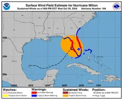
Hurricane Milton Tropical Cyclone Update
NWS National Hurricane Center Miami FL AL142024
600 PM EDT Wed Oct 09 2024
...LIFE-THREATENING STORM SURGE, DAMAGING WINDS, AND FLOODING RAINS
EXPECTED TONIGHT FOR PARTS OF CENTRAL AND SOUTHWESTERN FLORIDA...
...600 PM EDT POSITION UPDATE...
Heavy rainfall continues over the central Florida peninsula with
hurricane-force wind gusts beginning to occur along the Florida gulf
coast.
A sustained wind of 58 mph (93 km/h) and a gust of 77 mph (124 km/h)
was recently reported at a WeatherFlow station at Egmont Channel. A
sustained wind of 54 mph (87 km/h) and a gust of 66 mph (106 km/h)
was recently reported at the Albert Whitted Airport in
St. Petersburg.
The next update will be at 700 PM EDT (2300 UTC).
SUMMARY OF 600 PM EDT...2200 UTC...INFORMATION
-----------------------------------------------
LOCATION...27.0N 83.3W
ABOUT 50 MI...80 KM WSW OF SARASOTA FLORIDA
ABOUT 150 MI...250 KM SW OF ORLANDO FLORIDA
MAXIMUM SUSTAINED WINDS...120 MPH...205 KM/H
PRESENT MOVEMENT...NE OR 45 DEGREES AT 15 MPH...24 KM/H
MINIMUM CENTRAL PRESSURE...948 MB...28.00 INCHES
$$
Forecaster Papin/Mahoney/Camposano
Sinceramente, 200 Km/h é quase o mesmo em risco para vidas que 270 Km/h, com a agravante de que a precipitação aumenta.Pode ser que este enfraquecimento seja capaz de minimizar o número de vítimas.
Essa estação chegou a 170 km/hAlgumas estações no WU já registam 140 km/h, acima de 100 de média. Ainda estão online.
Personal Weather Station Dashboard | Weather Underground
Weather Underground provides local & long-range weather forecasts, weather reports, maps & tropical weather conditions for locations worldwide.www.wunderground.com