Monitorização Criosfera - 2007

Gerofil

Furacão
Registo
21 Mar 2007
Mensagens
10,059
Local
Estremoz
Novas ilhas emergem no Árctico em cenário de degelo recorde

Ilhas até agora desconhecidas estão a aparecer numa altura em que o degelo árctico no Verão atinge níveis recorde. A nova geografia levanta questões sobre se as alterações climáticas estão a ultrapassar as projecções das Nações Unidas, dizem vários peritos.
Ursos polares e focas também sofreram este ano no arquipélago norueguês de Svalbard porque o gelo onde caçavam derreteu muito mais cedo do que o normal.
“Reduções na neve e gelo estão a acontecer a um ritmo alarmante”, comentou a ministra do Ambiente norueguesa, Helen Bjoernoy, numa conferência que começou ontem e 40 cientistas e políticos em Ny Alesund, a 1200 quilómetros do Pólo Norte. “Esta aceleração pode ser mais rápida do que o previsto” pelo painel climático da ONU este ano, disse aos jornalistas na conferência que termina na quarta-feira.
O Painel Intergovernamental para as Alterações Climáticas (IPCC, sigla em inglês), que reúne 2500 cientistas, disse em Fevereiro que o gelo de Verão poderá quase desaparecer no mar árctico até ao final deste século. O sobre-aquecimento dos últimos 50 anos é, “muito provavelmente” o resultado dos gases com efeito de estufa causados pela utilização dos combustíveis fósseis.
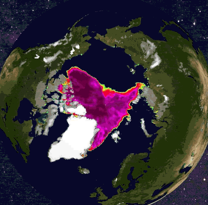
“Pode muito bem haver um Árctico sem gelo no meio deste século”, disse Christopher Rapley, director do British Antarctic Survey, na conferência, acusando o IPCC de subestimar o degelo. O recuo dos glaciares que avançam até ao mar à volta de Svalbard revelou várias ilhas que não estão nos mapas.
“Estão a aparecer ilhas” à medida que os glaciares recuam, comentou Kim Holmen, director de investigações no Instituto Polar Norueguês. “Conheço duas ilhas que apareceram a Norte de Svalbard este Verão. Ainda não foram reclamadas”, disse Rune Bergstrom, especialista em Ambiente no gabinete do governador de Svalbard. Este acrescentou que também apareceram mais ilhas ao largo da Gronelândia e do Canadá.
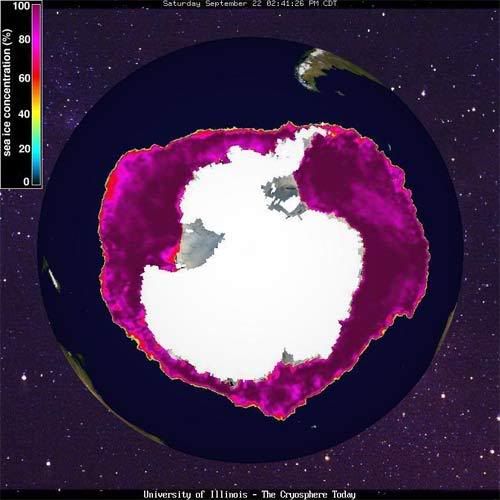
Rapley também disse que o IPCC foi “limitado ao ponto de ser gravemente enganador”. O norte-americano National Snow and Ice Data Center informou na sexta-feira que o gelo no mar árctico “caiu abaixo do recorde de mínimo absoluto de 2005 e ainda está a derreter”. Este gelo atinge o mínimo anual em Setembro, altura em que começa a congelar novamente.
Rapley lembrou que o degelo pode ser mau para os povos indígenas e para a vida selvagem mas será bom para todos os que andam à caça de petróleo e gás natural ou para abrir passagens entre os oceanos Atlântico e Pacífico.
Com a conferência, a Noruega espera pressionar os Governos a aceitarem maiores reduções das emissões de gases com efeito de estufa, disse Bjoernoy.

PÚBLICO
 
Última edição:


Gerofil

Furacão
Registo
21 Mar 2007
Mensagens
10,059
Local
Estremoz
Re: Novas ilhas emergem no Árctico em cenário de degelo recorde

Degelo no mar árctico atinge novo recorde

A superfície gelada no mar do Árctico atingiu este mês um novo recorde mínimo, com apenas 4,42 milhões de quilómetros quadrados, revela o National Snow and Ice Data Center da Universidade do Colorado, em Denver. Até agora, o recorde ia para o ano de 2005, com 5,32 milhões de quilómetros quadrados. Os cientistas dizem-se “espantados” com a perda de gelo. Só na semana passada desapareceu uma área quase duas vezes maior do que a Grã-bretanha, noticia hoje o jornal britânico “The Guardian”.
A passagem marítima Nordeste ao longo da costa russa do Árctico poderá abrir no final deste mês. Se o degelo, que acelerou a partir de 2002, continuar a este ritmo, o Árctico poderá ficar sem gelo no Verão em 2030. “Se me tivessem perguntado há uns anos quando iria o Árctico perder todo o seu gelo, teria dito 2100 ou 2070. Mas agora penso que 2030 é uma estimativa razoável. Parece que o Árctico vai ser um espaço muito diferente ainda na nossa geração e certamente na dos nossos filhos”, comentou Mark Serreze, do National Snow and Ice Data Centre, citado pelo “The Guardian”.
O degelo no Árctico ocorre todos os meses de Setembro. No Inverno, a água do mar recomeça a congelar. Mas este ano, esse processo será mais difícil. “Este Verão temos toda esta água [sem gelo] que faz entrar calor no oceano. Isso vai dificultar o regresso do gelo. O que estamos a ver este ano permite mostrar-nos que o próximo será pior”, acrescentou.
Alterações nos ventos e circulação de correntes podem contribuir para o degelo. Mas Serreze acredita que o maior culpado é o sobre-aquecimento do planeta. “As regras começam a mudar e o que está a mudar as regras são as emissões de gases com efeito de estufa”.

Fonte: PÚBLICO
 
Última edição:

Vince

Furacão
Registo
23 Jan 2007
Mensagens
10,624
Local
Braga
Re: Alterações Climáticas: Degelo no Árctico

Record July Arctic sea ice loss


Sea ice extent in the Arctic in July 2007 set a record low, posting a large 7% decline compared to July 2006. July marked the third month this year that a record monthly low was set. Arctic sea ice coverage in July has declined by about 26% since measurements began in 1979 (Figure 1). The trailing end of Figure 1 shows a very striking drop, so it's worth investigating this decline in more detail.


seaice_jul.png

Figure 1. Arctic sea ice extent for July, for the years 1979-2007. July 2007 had the lowest Arctic sea ice extent since satellite measurements began in 1979. July sea ice coverage has declined about 26% since 1979. Image credit: National Snow and Ice Data Center.

What caused the July sea ice loss?

Sea ice in July over the past 28 years has shown a steady decline, punctuated by ups and downs characteristic of year-to-year natural variability in the weather patterns over the Arctic. The steady decline is largely due to increasing temperatures in the Arctic from global warming, but a significant portion is due to changing wind patterns. As I discussed in detail in a blog earlier this year, much of the 1990s saw lower than average pressure over the Arctic, which drove stronger than average westerly winds along the north coast of Canada. These west-to-east winds acted to push ice out of the Arctic through Fram Strait, the region between Greenland and Europe. Was a similar wind pattern responsible for the July 2007 decline in ice?


jul2007_wind.png

Figure 2. Surface wind for the Arctic averaged for July 2007.

A plot of the surface wind speed for July 2007 (Figure 2) shows that the meteorology of July 2007 led to a wind pattern the opposite of the one in the early 1990s that pushed so much ice out of the Arctic. In July 2007, surface winds blew from east to west along the north shore of Canada, rotating clockwise around a high pressure system over the North Pole. It is more difficult to flush ice out of the Arctic with this kind of wind pattern. There were very strong north-to-south winds over Fram Strait--in excess of 7 m/s (about 14 mph). The wind is normally nearly calm in this region in July, so these strong winds did account for a small portion of the July 2007 record sea ice loss.

By comparing the sea ice coverage in July 2006 versus 2007 (Figure 3), we can identify areas along the northern coasts of Russia and Canada where most of the melting in 2007 occurred. A plot of the temperature anomalies (how far temperature differed from average) for July 2007 (Figure 4) show that the greatest ice loss in July 2007 occurred where temperatures much above average occurred. Thus, it appears that warming, and not wind patterns, was primarily responsible for the record July 2007 sea ice loss.

I asked Dr. Mark Serreze, a Arctic sea ice expert at the National Snow and Ice Data Center, about the record July sea ice loss. His comments:

We see a strongly anticyclonic atmospheric circulation at sea level in July over the Arctic Ocean. This seems to be fostering rather clear skies, promoting strong melt. Also, if you look at the temperature anomalies for July, there is an area of very warm conditions along eastern Siberia, on the west side of the anticyclone where winds have a southerly component. Southerly winds will also "push" the ice away from shore, helping to reduce ice extent along the Siberian coast. Having said this, we are also strongly seeing "memory" of past conditions. We started out on a bad footing with ice extent in May 2007 well below norms. There also seems to be very little thick ice in the Arctic Ocean--as the ice is thinner, large areas can melt out in summer. At the current rate of loss, it's a good bet that we will exceed the record 2005 September ice minimum. However, last year, we were on track to set a new record, until it got colder and stormier in August. In essence, we were "saved by the bell". Hence, we'll just have to wait and see.


seaice_jul2006-2007.png

Figure 3. Comparison of Sea ice extent for July 2006 and July 2007. Major sea ice loss in July 2007 compared to July 20006 occurred along the north coast of Russia and Canada.


jul2007_tempanonalies.png

Figure 4. Temperature anomalies (how far temperature differed from average) for July 2007. Much warmer than average temperatures were observed over the land areas adjacent to where the major sea ice losses occurred.

The implications
This July's major loss of sea ice will amplify sea ice loss the remainder of the summer, due to a positive feedback loop. As sea ice melts in response to rising temperatures, more of the dark ocean is exposed, allowing it to absorb more of the sun's energy. This further increases air temperatures, ocean temperatures, and ice melt in a process know as the "ice-albedo feedback" (albedo means how much sunlight a surface reflects). The July 2007 ice loss may mean that a runaway "ice-albedo feedback" has taken hold, which will amplify until the Arctic Ocean is entirely ice-free later this century. Other scientists will disagree, but I believe that such a runaway ice-albedo feedback has taken hold.

The melting of the Arctic sea ice will not raise ocean levels appreciably, since the ice is already floating in the ocean. However, it will bring warmer temperatures to the Arctic, which will accelerate the melting of the Greenland Ice Cap. This ice sheet holds enough water to raise sea level 20 feet--though much less melting is expected this century, with only a 0.6-1.9 foot sea level rise predicted. Loss of Arctic sea ice will also dramatically change the global weather and precipitation patterns. For example, the jet stream should move further north, bringing more precipitation to the Arctic, and more frequent droughts over the U.S. In any case, the reduced Artic sea ice should give us another delayed start to winter in the Northern Hemisphere this year.

Beginning today, the National Snow and Ice Data Center has begun a blog providing expert analysis of this summer's record Arctic sea ice loss. Expect weekly updates from now until Arctic sea ice reaches its minimum extent in September.
(c) Jeff Masters
 

Vince

Furacão
Registo
23 Jan 2007
Mensagens
10,624
Local
Braga
Re: Alterações Climáticas: Degelo no Árctico

4 September 2007
Overview of current sea ice conditions

Sea ice extent continues to decline, and is now at 4.42 million square kilometers (1.70 million square miles), falling yet further below the record absolute minimum of 5.32 million square kilometers (2.05 million square miles) that occurred on September 20–21, 2005.

20070904_extentthumb.gif

Figure 1: Sea ice extent for for September 3, 2007

Figure 1 provides the updated map of sea ice extent for September 3, 2007; the magenta line shows the median September extent based on data from 1979 to 2000. Sea ice extent now stands at 4.42 million square kilometers (1.70 million square miles).


20070904_timeseriesthumb.gif

Figure 2: Summer melt season Arctic sea ice extent

Figure 2 is the updated time series of daily ice extent for 2007, which can be compared to the time series for 2005 and to the 1979 to 2000 average. Compared to conditions cited in our last entry, we have lost an additional 360,000 square kilometers (138,000 square miles) of ice, an area larger than the size of the state of New Mexico. We noted in our last entry that the daily rate of ice loss was starting to slow; the loss rate has increased again, as Figure 2 shows.

20070904_augtrendthumb.gif

Figure 3: August time series of monthly average ice extent

Figure 3 provides a time-series of monthly average sea ice extent from August 1979 to August 2007. The low ice extent for August 2007 stands out sharply compared to all previous Augusts. The August 2007 monthly average extent was 5.32 million square kilometers (2.05 million square miles), falling well below August 2005 extent, which was 6.30 million square kilometers (2.42 million square miles). Additionally, August 2007 ice extent is 31% below the long-term average of 7.67 million square kilometers (2.95 million square miles).

Even more stunning is that the August 2007 monthly average is the lowest extent in the satellite record for any month, including any previous September, which is typically the lowest month each year. September 2005, the previous record, had a monthly mean extent of 5.56 million square kilometers (2.14 million square miles).

August 2007 sea ice extent was lower than September 2005 extent by 240,000 square kilometers (92,000 square miles).


20070904_modisthumb.gif

Figure 4: Arctic sea ice image from August 29, 2007

Satellite image of Arctic above Greenland

Data: from MODIS satellite. Credit: National Snow and Ice Data Center.
High Resolution Image

Another notable aspect of August 2007 was the opening of the Northwest Passage (see red line in Figure 4 and August 22 entry below). During August 2007, the passage was the most navigable that people have seen since monitoring began. The Northeast Passage, along the Russian coast, is still blocked by fairly heavy ice conditions north of the Taymyr Peninsula (near the top of Figure 1).

Might the Northeast Passage open in the next few weeks? We will be monitoring the situation.

(c) National Snow and Ice Data Center (NSIDC) - Arctic Sea Ice News Fall 2007
 

Vince

Furacão
Registo
23 Jan 2007
Mensagens
10,624
Local
Braga
Seguimento Criosfera

Enquanto continua o degelo no Ártico com mínimos históricos desde que há registos, no Polo Sul acontece o inverso. A cobertura está próxima do máximo histórico desde que há registos (1979).

ps.jpg


Close to record SH sea ice maximum and NH sea ice minimum
Just when you thought this season's cryosphere couldn't be more strange .... The Southern Hemisphere sea ice area is close to surpassing the previous historic maximum of 16.03 million sq. km and is currently at 15.91 million sq. km. The observed sea ice record in the Southern Hemisphere (1979-present) is not as long as the Northern Hemisphere. Prior to the satellite era, direct observations of the SH sea ice edge were sporadic.
Fonte: Cryosphere Today
 

duncan

Cumulus
Registo
24 Set 2006
Mensagens
150
Local
palmela
Re: Antárctica: cobertura de gelo próximo dos máximos

estranho,este aumento do gelo na antartica,contradiz com as previsoes do aquecimento global:huh:
 

Minho

Cumulonimbus
Registo
6 Set 2005
Mensagens
4,091
Local
Melgaço
Re: Seguimento Criosfera

Continua o alarmante degelo do Árctico, com um desvio da normal assinalável


current365zc7.jpg


Animação dos últimos 30 dias no HN


Lmk.gif


Enquanto na Antárctida continuam as anomalias positivas...

current365southia8.jpg


No Hemisfério Norte a neve já fez acto de presença nos Estados Unidos e em Grande parte dos Alpes

cursnowusags6.gif


cursnowasiaeuropems5.gif


Fonte
http://www.ssd.noaa.gov/PS/SNOW/
http://arctic.atmos.uiuc.edu/cryosphere/
 

Minho

Cumulonimbus
Registo
6 Set 2005
Mensagens
4,091
Local
Melgaço

Minho

Cumulonimbus
Registo
6 Set 2005
Mensagens
4,091
Local
Melgaço
Re: Seguimento Criosfera

Hemisfério Norte....


Grande expansão dos gelos nestes últimos 8 dias. Destaque também para a cobertura de neve assinalável na Escandinávia...

arctic08112007hq0.jpg


Importante recuperação da área de gelo... parece ter sido dado o clique para o Inverno começar...


current365mg4.jpg


FONTE
 

Minho

Cumulonimbus
Registo
6 Set 2005
Mensagens
4,091
Local
Melgaço
Re: Seguimento Criosfera

Um estudo da NASA publicado no dia 1 de Outubro sobre a diminuição da área de gelo permanente (perennial ice) no árctico considera que a diminuição do gelo terá tido como principais causas a alterações dos padrões dos ventos e não a subida das temperaturas.

A team led by Son Nghiem of NASA's Jet Propulsion Laboratory, Pasadena, Calif., studied trends in Arctic perennial ice cover by combining data from NASA's Quick Scatterometer (QuikScat) satellite with a computing model based on observations of sea ice drift from the International Arctic Buoy Programme. QuikScat can identify and map different classes of sea ice, including older, thicker perennial ice and younger, thinner seasonal ice.

The scientists observed less perennial ice cover in March 2007 than ever before, with the thick ice confined to the Arctic Ocean north of Canada. Consequently, the Arctic Ocean was dominated by thinner seasonal ice that melts faster. This ice is more easily compressed and responds more quickly to being pushed out of the Arctic by winds. Those thinner seasonal ice conditions facilitated the ice loss, leading to this year's record low amount of total Arctic sea ice.

Nghiem said the rapid decline in winter perennial ice the past two years was caused by unusual winds. "Unusual atmospheric conditions set up wind patterns that compressed the sea ice, loaded it into the Transpolar Drift Stream and then sped its flow out of the Arctic," he said. When that sea ice reached lower latitudes, it rapidly melted in the warmer waters.

"The winds causing this trend in ice reduction were set up by an unusual pattern of atmospheric pressure that began at the beginning of this century," Nghiem said.


The Arctic Ocean's shift from perennial to seasonal ice is preconditioning the sea ice cover there for more efficient melting and further ice reductions each summer. The shift to seasonal ice decreases the reflectivity of Earth's surface and allows more solar energy to be absorbed in the ice-ocean system.

The perennial sea ice pattern change was deduced by using the buoy computing model infused with 50 years of data from drifting buoys and measurement camps to track sea ice movement around the Arctic Ocean. From the 1970s through the 1990s, perennial ice declined by about 500,000 square kilometers (193,000 square miles) each decade. Since 2000, that amount of decline has nearly tripled.


Artigo Completo
 

Minho

Cumulonimbus
Registo
6 Set 2005
Mensagens
4,091
Local
Melgaço
Re: Seguimento Criosfera

Grande recuperação do gelo no Árctico... já atingiu o nível de há um ano atrás


001os7.jpg


current365ht1.jpg


Boa cobertura de neve na Europa! Estamos bem melhor que o ano passado...:rolleyes:

cursnowasiaeuropefq1.gif