Monitorização Teleconexões ENSO/NAO/AO/PDO/etc- 2008

Vince

Furacão
Registo
23 Jan 2007
Mensagens
10,624
Local
Braga
Tópico de monitoramento e discussão de Teleconexões em 2008, em especial a ENSO (El Nino-Oscilacao Sul), Oscilação Atlântico Norte (OAN/NAO ) e a Oscilação do Ártico (OA/AO), etc.


Links úteis:


ENSO - El Nino-Oscilação Sul / El Niño-Southern Oscillation

-> NOOA Climate Prediction Center - El Niño / Southern Oscillation (ENSO)
-> BOM Australia Seasonal Outlooks ENSO Wrap-Up


NAO - Oscilação Atlântico Norte - North Atlantic oscillation

-> NOAA Climate Prediction Center - NAO (North Atlantic Oscillation)
-> North Atlantic Oscillation
-> The Arctic Oscillation (AO) and the North Atlantic Oscillation (NAO)
-> North Atlantic Oscillation


AO - Oscilação Ártico / Arctic Oscillation

-> Climate Prediction Center - Arctic Oscillation
-> The Arctic Oscillation (AO) and the North Atlantic Oscillation (NAO)
-> Arctic Oscillation (AO) time series


AAO Oscilação Antártica - Antarctic Oscillation

-> Antarctic Oscillation - Climate Prediction Center


PNA Padrão Pacífico-América do Norte / Pacific North American Pattern

-> Climate Prediction Center - Pacific/North American Pattern


Vince

Furacão
Registo
23 Jan 2007
Mensagens
10,624
Local
Braga
Re: Monitoramento Teleconexões (ENSO/NAO/AO/etc) - 2008

Evolução nos últimos meses do indíce NAO e previsões até 17 Março.

naoda0.png
 

Vince

Furacão
Registo
23 Jan 2007
Mensagens
10,624
Local
Braga
Re: Monitoramento Teleconexões (ENSO/NAO/AO/etc) - 2008

O último relatório disponibilizado hoje pelo CPC sobre a situação da «La Ninã»

Synopsis: La Niña is expected to continue through the Northern Hemisphere spring 2008.

Atmospheric and oceanic conditions during February 2008 continued to reflect a strong La Niña. Equatorial SSTs were more than 2.0°C below average across large portions of the central and east-central equatorial Pacific (Fig. 1), and the corresponding weekly values of the Niño-4 and Niño-3.4 indices remained between -1.6°C and -2.1°C during the month (Fig. 2). In contrast, SSTs in the far eastern equatorial Pacific were above average during February 2008, in association with a warming trend that began in mid-December. The upper-ocean heat content (average temperatures in the upper 300m of the oceans between 180° - 100°W) remained below average across the equatorial Pacific during February (Fig. 3), with the largest temperature anomalies averaging -2°C to -6°C at thermocline depth (Fig. 4). Consistent with these oceanic conditions, stronger-than-average low-level easterly winds and upper-level westerly winds persisted across the central equatorial Pacific, convection remained suppressed throughout the central equatorial Pacific, and enhanced convection covered the far western Pacific. Collectively, these oceanic and atmospheric conditions are similar to those accompanying the last strong La Niña episode in 1998-2000.

The most recent dynamical and statistical SST forecasts for the Niño 3.4 region continue to indicate a moderate-to-strong La Niña through March 2008, and a weaker La Niña through April-May-June 2008 (Fig. 5). Thereafter, there is considerable spread in the forecasts, with approximately one-half indicating that La Niña could continue into the Northern Hemisphere fall. Current atmospheric and oceanic conditions and recent observed trends support the likely continuation of La Niña through the Northern Hemisphere spring 2008.

Expected La Niña impacts during March-May 2008 include a continuation of above-average precipitation over Indonesia and below-average precipitation over the central equatorial Pacific. The above average SSTs in the eastern equatorial Pacific may result in increased rainfall over Ecuador and northern Peru, similar to the evolution during the 1998-2000 La Niña episode. Compared to the Northern Hemisphere winter, La Niña impacts over the United States in spring are typically less pronounced. The primary springtime signal for the contiguous United States is an increased probability of below-average precipitation across the South, particularly in the Southeast.

http://www.cpc.ncep.noaa.gov/products/analysis_monitoring/enso_advisory/ensodisc.html


Anomalias

nino2gi6.png


Anomalias por Região Nino.

ninokr8.png
 

Mário Barros

Furacão
Registo
18 Nov 2006
Mensagens
12,603
Local
Maçores (Torre de Moncorvo) / Algueirão (Sintra)
Re: Monitoramento Teleconexões ENSO/NAO/AO/etc- 2008

Já está a entrar em terreno positivo ai vem a chuva :D:D

Será que se irão repetir os cenários de 2001 na Europa durante o Verão ?
 

Vince

Furacão
Registo
23 Jan 2007
Mensagens
10,624
Local
Braga
Re: Monitoramento Teleconexões ENSO/NAO/AO/etc- 2008

ENSO


eno.gif


en-so.gif


La Niña is expected to continue for the next 3 months.
La Niña declined to moderate-strength during March 2008 as negative sea surface temperature (SST) anomalies weakened across the central and east-central equatorial Pacific. The latest weekly SSTs are more than 1.0°C below average in areas between 160°E and 120°W (Fig. 1). All of the Niño indices warmed during March (Fig. 2), with only the westernmost Niño-4 and Niño-3.4 regions having values nearly 1.0°C below average. Above-average SSTs remained restricted to the far eastern equatorial Pacific in association with a significant warming trend that began in mid-December. In the central Pacific, the subsurface temperature anomalies also lessened (averaging -1°C to -4°C at thermocline depth), and became increasingly confined to the surface region (Fig. 3). This evolution led to a significant weakening of the negative ocean heat content anomalies (average temperatures in the upper 300m of the ocean; Fig 4). Despite this oceanic trend, the atmospheric conditions continue to strongly reflect La Niña. Enhanced low-level easterly winds and upper-level westerly winds persisted across the central equatorial Pacific, convection remained suppressed throughout the central equatorial Pacific, and enhanced convection covered the far western Pacific. Collectively, these atmospheric and oceanic conditions indicate an ongoing, but weaker, La Niña.

The recent dynamical and statistical SST forecasts for the Niño 3.4 region indicate La Niña will become weak and persist through May-June-July 2008 (Fig. 5). Thereafter, there is considerable spread in the forecasts, with nearly one-half indicating La Niña could continue well into the second half of the year. Based on current atmospheric and oceanic conditions and recent trends, La Niña is expected to continue for the next 3 months.

Expected La Niña impacts during April-June include a continuation of above-average precipitation over Indonesia and below-average precipitation over the central equatorial Pacific. Compared to the Northern Hemisphere winter, La Niña impacts over the United States in spring are typically less pronounced. The main April-June signal for the contiguous United States is an increased probability of below-average precipitation over parts of the Southwest extending from Texas to Nevada.

http://www.cpc.ncep.noaa.gov/products/analysis_monitoring/enso_advisory/ensodisc.html
 

Vince

Furacão
Registo
23 Jan 2007
Mensagens
10,624
Local
Braga
Re: Monitoramento Teleconexões ENSO/NAO/AO/etc- 2008

A La Ninã continua a enfraquecer, e é possível que fique neutral nos próximos meses.

La Niña weakens further, especially in the east

The La Niña event in the Pacific basin has continued to weaken during the past two weeks, with the surface of the equatorial Pacific warming by about 0.1 to 0.2°C. While western Pacific surface temperatures remain typical for a La Niña event, eastern Pacific temperatures have now been out of the La Niña range for the last five weeks. Below the surface, the cold water in the eastern Pacific has continued to warm and decrease in volume.

These observations from the eastern Pacific show a faster decline in La Niña conditions than was forecast by most computer models. Model predictions now show central to western Pacific temperatures warming back to the neutral range during the next one to three months. The models do not suggest El Niño conditions will return during 2008.

The other main ENSO indicators consisting of the Southern Oscillation Index (SOI), western Pacific Trade Winds and Pacific cloudiness remain typical of La Niña.

In Brief

* The La Niña event is weakening.
* Negative SST anomalies are weaker and have continued to shift towards the west Pacific
* Warm sub-surface anomalies in the west have strengthened recently, while cool anomalies in the east have weakened.
* The SOI remains positive at +12.
* Trade Winds remain stronger than average across the western equatorial Pacific, but are weaker in the east.
* Cloudiness near the date-line has been very much below average in recent months.
* All the dynamic computer models predict La Niña conditions in the central Pacific to decay to neutral over the next couple of months.
http://www.bom.gov.au/climate/enso/
 

Paulo H

Cumulonimbus
Registo
2 Jan 2008
Mensagens
3,271
Local
Castelo Branco 386m(489/366m)
Re: Monitorização Teleconexões ENSO/NAO/AO/etc- 2008

Outros links muito interessantes:

http://www.pfeg.noaa.gov/research/publications/PDF/Primary/NOI.pdf

Aborda as teleconexões entre vários índices (NOI, SOI, NEP), dando relevância à sua melhor aplicação - fenómenos ambientais, biológicos e flutuações climáticas.

"5. Conclusions

The NOI and SOI time series are generally similar, but provide distinct perspectives on a range of climate variations. Their disparities result mainly from differences between tropical and Northern Hemi-sphere extratropical variability on interannual scales, which are the result of such things as differences in the proximity and strength of major energy sources for climatic variations (e.g. western tropical Pacific warm pool, Asian monsoon region, subtropical jets, NEP ocean temperature anomalies). A number of studies have shown that the SOI is strongly correlated with many environmental and biological parameters in the NEP. This correspondence may be more a product of the general correlation of SLP in the Asia-Pacific region to the NEP (cf. Fig. 2a) than to a direct physical link. Both the NOI and the SOI have merits, but for the NEP, the NOI appears to be equal or superior in terms of statistical correlations, and a more relevant index of the physical mechanisms responsible for environmental variability.
The NPH is a major link between the atmosphere and ocean in the NEP. Because of the role of the NPH in the H-W circulation, its variations are a good indicator of the impacts of large-scale climate change on the NEP. NPH variations also summarize the regional mechanisms responsible for oceanic anomalies in the NEP, since they are linked closely to the surface winds that drive oceanic processes. Thus an index based on the NPH is likely to be well correlated with climate change events over the North Pacific-North American region, including a wide range of upper ocean changes in the NEP. Because the ocean in the NEP responds to regional atmospheric forcing as well as to teleconnections from the tropical Pacific, the NOI embodies both local and remote forcing mechanisms, and therefore represents more sources of variation in the NEP than a purely tropically or extratropically based index (e.g. the SOI or NPH alone). Climate processes known to have large physical and biological impacts on the NEP are well represented by the NOI. The encouraging relationships between the NOI and a variety of physical and biological data series suggests this index may be a reliable indicator of climate fluctuations in the NEP, and provides insights on the mechanisms linking the physical environment to marine resources."
in "The Northern Oscillation Index (NOI): A new climate index for the northeast Pacific F.B. Schwing a,∗, T. Murphree b, P.M. Green c"


http://www.metsul.com

Ver também: http://www.metsul.com/secoes/?cod_subsecao=57
 

Vince

Furacão
Registo
23 Jan 2007
Mensagens
10,624
Local
Braga
Re: Monitorização Teleconexões ENSO/NAO/AO/etc- 2008

Bem, cabe-me dar a boa nova destes dias aos amantes do frio. Resta saber se são mesmo boas notícias para a alimentação mundial e os preços já inflacionados da energia.

A NASA chegou à conclusão que apesar da La Ninã estar a enfraquecer o alastrar de águas mais frias no Pacífico indicam que estamos possivelmente perante algo que tem sinais de parecer a entrada na fase fria de um padrão chamada Oscilação Decadal do Pacífico (PDO Pacific Decadal Oscillation).
Este padrão é menos falado porque temporalmente pode durar 2 ou 3 décadas ao contrário dos Ninos/Ninas que duram de 6 a 18 meses. A confirmar-se e daquilo que se sabe pode ter implicações no clima mundial pois está relacionado com frio, La Ninãs mais intensas e El Ninos mais fracos e curtos. A última vez que se entrou numa fase fria desta oscilação foi em 1946 que se manteve até aos anos 70.

Ainda não há certezas absolutas pois em 1998 (e noutras ocasiões) no fim de uma La Ninã também houve sinais de entramos numa fase destas que não se manteve, tivemos até um El Nino muito poderoso logo em cima disso.

pdobi2.gif


La Nina and Pacific Decadal Oscillation Cool the Pacific

pdozv2.gif


A cool-water anomaly known as La Niña occupied the tropical Pacific Ocean throughout 2007 and early 2008. In April 2008, scientists at NASA’s Jet Propulsion Laboratory announced that while the La Niña was weakening, the Pacific Decadal Oscillation—a larger-scale, slower-cycling ocean pattern—had shifted to its cool phase.

This image shows the sea surface temperature anomaly in the Pacific Ocean from April 14–21, 2008. The anomaly compares the recent temperatures measured by the Advanced Microwave Scanning Radiometer for EOS (AMSR-E) on NASA’s Aqua satellite with an average of data collected by the NOAA Pathfinder satellites from 1985–1997. Places where the Pacific was cooler than normal are blue, places where temperatures were average are white, and places where the ocean was warmer than normal are red.

The cool water anomaly in the center of the image shows the lingering effect of the year-old La Niña. However, the much broader area of cooler-than-average water off the coast of North America from Alaska (top center) to the equator is a classic feature of the cool phase of the Pacific Decadal Oscillation (PDO). The cool waters wrap in a horseshoe shape around a core of warmer-than-average water. (In the warm phase, the pattern is reversed).

Unlike El Niño and La Niña, which may occur every 3 to 7 years and last from 6 to 18 months, the PDO can remain in the same phase for 20 to 30 years. The shift in the PDO can have significant implications for global climate, affecting Pacific and Atlantic hurricane activity, droughts and flooding around the Pacific basin, the productivity of marine ecosystems, and global land temperature patterns. “This multi-year Pacific Decadal Oscillation ‘cool’ trend can intensify La Niña or diminish El Niño impacts around the Pacific basin,” said Bill Patzert, an oceanographer and climatologist at NASA's Jet Propulsion Laboratory, Pasadena, Calif. “The persistence of this large-scale pattern [in 2008] tells us there is much more than an isolated La Niña occurring in the Pacific Ocean.”

Natural, large-scale climate patterns like the PDO and El Niño-La Niña are superimposed on global warming caused by increasing concentrations of greenhouse gases and landscape changes like deforestation. According to Josh Willis, JPL oceanographer and climate scientist, “These natural climate phenomena can sometimes hide global warming caused by human activities. Or they can have the opposite effect of accentuating it.”

NASA image by Jesse Allen, AMSR-E data processed and provided by Chelle Gentemann and Frank Wentz, Remote Sensing Systems. Caption by Rebecca Lindsey, adapted from a press release from NASA JPL.

http://earthobservatory.nasa.gov/Newsroom/NewImages/images.php3?img_id=18012

Larger Pacific Climate Event Helps Current La Nina Linger

PASADENA, Calif. – Boosted by the influence of a larger climate event in the Pacific, one of the strongest La Niñas in many years is slowly weakening but continues to blanket the Pacific Ocean near the equator, as shown by new sea-level height data collected by the U.S.-French Jason oceanographic satellite.


This La Niña, which has persisted for the past year, is indicated by the blue area in the center of the image along the equator. Blue indicates lower than normal sea level (cold water). The data were gathered in early April.

The image also shows that this La Niña is occurring within the context of a larger climate event, the early stages of a cool phase of the basin-wide Pacific Decadal Oscillation. The Pacific Decadal Oscillation is a long-term fluctuation of the Pacific Ocean that waxes and wanes between cool and warm phases approximately every five to 20 years. In the cool phase, higher than normal sea-surface heights caused by warm water form a horseshoe pattern that connects the north, west and southern Pacific, with cool water in the middle. During most of the 1980s and 1990s, the Pacific was locked in the oscillation's warm phase, during which these warm and cool regions are reversed. For an explanation of the Pacific Decadal Oscillation and its present state, see: http://jisao.washington.edu/pdo/ and http://www.esr.org/pdo_index.html .

A La Niña is essentially the opposite of an El Niño. During El Niño, trade winds weaken and warm water occupies the entire tropical Pacific Ocean. Heavy rains tied to the warm water move into the central Pacific Ocean and cause drought in Indonesia and Australia while altering the path of the atmospheric jet stream over North and South America. During La Niña, trade winds are stronger than normal. Cold water that usually sits along the coast of South America is pushed to the middle of the equatorial Pacific. A La Niña changes global weather patterns and is associated with less moisture in the air, and less rain along the coasts of North and South America.

“This multi-year Pacific Decadal Oscillation 'cool' trend can intensify La Niña or diminish El Niño impacts around the Pacific basin," said Bill Patzert, an oceanographer and climatologist at NASA's Jet Propulsion Laboratory, Pasadena, Calif. "The persistence of this large-scale pattern tells us there is much more than an isolated La Niña occurring in the Pacific Ocean."

Sea surface temperature satellite data from the National Oceanic and Atmospheric Administration also clearly show a cool Pacific Decadal Oscillation pattern, as seen at: http://www.cdc.noaa.gov/map/images/sst/sst.anom.gif . The shift in the Pacific Decadal Oscillation, with its widespread Pacific Ocean temperature changes, will have significant implications for global climate. It can affect Pacific and Atlantic hurricane activity, droughts and flooding around the Pacific basin, marine ecosystems and global land temperature patterns.

“The comings and goings of El Niño, La Niña and the Pacific Decadal Oscillation are part of a longer, ongoing change in global climate,” said Josh Willis, a JPL oceanographer and climate scientist. Sea level rise and global warming due to increases in greenhouse gases can be strongly affected by large natural climate phenomenon such as the Pacific Decadal Oscillation and the El Nino-Southern Oscillation. “In fact,” said Willis, “these natural climate phenomena can sometimes hide global warming caused by human activities. Or they can have the opposite effect of accentuating it.”

Jason's follow-on mission, the Ocean Surface Topography Mission/Jason-2, is scheduled for launch this June and will extend to two decades the continuous data record of sea surface heights begun by Topex/Poseidon in 1992. JPL manages the U.S. portion of the Jason mission for NASA's Science Mission Directorate, Washington, D.C.

http://www.jpl.nasa.gov/news/news.cfm?release=2008-066
 

Vince

Furacão
Registo
23 Jan 2007
Mensagens
10,624
Local
Braga
Re: Monitorização Teleconexões ENSO/NAO/AO/etc- 2008

Continua a tendência para uma fase neutral do ENSO e o fim próximo da La Ninã mas que ainda inflencia o padrão de ventos. O CPC/NCEP não prevê que entremos num El Nino pelo menos até ao final do ano.

ENSO Cycle: Recent Evolution, Current Status and Predictions
Climate Prediction Center / NCEP
16 June 2008

•A transition from La Niña to ENSO-neutral is underway in the equatorial Pacific Ocean.
•Equatorial SSTs in the central Pacific Ocean remain below average, but negative departures have weakened considerably since mid-February 2008.
•The patterns of tropical convection and winds continue to reflect La Niña.
•Based on recent equatorial Pacific SST trends and model forecasts, ENSO-neutral conditions are expected to continue through the NorthernHemisphere summer months.

http://www.cpc.ncep.noaa.gov/products/analysis_monitoring/lanina/enso_evolution-status-fcsts-web.pdf


Os australianos tem a mesma opinião:

ENSO Wrap-Up
A regular commentary on the El Niño-Southern Oscillation
CURRENT STATUS as at 18th June 2008

The neutral ENSO pattern across the equatorial Pacific consolidated during the past fortnight. In particular, there was some reversal of the warming trend in the eastern Pacific, with ocean temperatures there now slightly cooler than a fortnight ago. Previous warming in this region had been in part due to weakened Trade Winds, but the Trades have returned to near normal across the equatorial Pacific. In addition, the SOI remains close to zero and cloudiness is above average in the region of the date-line for the first time since February, all suggesting neutral conditions have become firmly established.

The majority of computer model predictions show the neutral pattern continuing over the coming months. Whilst all models predict some warming during the next two seasons, most indicate temperatures remaining in the neutral range below the El Niño thresholds. However, as ENSO events can evolve quite rapidly at this time of year, the Pacific will continue to be monitored closely for any signs of El Niño growth.

http://www.bom.gov.au/climate/enso/
 

Mário Barros

Furacão
Registo
18 Nov 2006
Mensagens
12,603
Local
Maçores (Torre de Moncorvo) / Algueirão (Sintra)
Re: Monitorização Teleconexões ENSO/NAO/AO/etc- 2008

O Atlântico estara bem instável nos próximos tempos :D devido há NAO :rain: mas depois alguma estabilidade a partir de dia 1.


Mário Barros

Furacão
Registo
18 Nov 2006
Mensagens
12,603
Local
Maçores (Torre de Moncorvo) / Algueirão (Sintra)
Re: Monitorização Teleconexões ENSO/NAO/AO/etc- 2008

Parece que estamos no pico da estabilidade da NAO, a qualquer momento ela começará a entrar numa fase mais negativa :D e já sabemos no que isso pode resultar :cold: :rain: provavelmente ao longo dos próximos tempos iremos assistir a uma diminuição não só do tamanho do AA como o seu consequente enfraquecimento.


Agreste

Furacão
Registo
29 Out 2007
Mensagens
10,032
Local
Terra
Re: Monitorização Teleconexões ENSO/NAO/AO/etc- 2008

Altura de actualizar os dados. Parece que os próximos 15 dias serão Cold & Dry... :(


naosprd2dr4.gif
 

psm

Nimbostratus
Registo
25 Out 2007
Mensagens
1,509
Local
estoril ,assafora
Re: Monitorização Teleconexões ENSO/NAO/AO/etc- 2008

Venho apresentar uma das variaveis para nós termos uma situação não muito favoravel para condições de instabilidade. A temperatura da água do mar no Atlantico norte

Aqui poderemos ver a variação entre os valores negativos em relação à normal e positivos, com a média da temperatura da água do mar, a nivel mundial.

ncoda_1440x721_global_anomcc-1.gif


No 2º podemos ver a temperatura como se apresenta na sua forma normal.

ncoda_1440x721_global_sstgg.gif


ps: Devo salientar, que nesta situação de bloqueio anticiclonico agora presente, tem como principal razão estar a acontecer nos altos niveis da atmosfera.
 

Vince

Furacão
Registo
23 Jan 2007
Mensagens
10,624
Local
Braga
pdo:

oscillation rules as the pacific cools

Jason_1_animated-640.gif

a cool wedge of lower-than-normal sea-surface heights continues to dominate the tropical pacific, ringed by a horseshoe of warmer waters. The continuation of this long-term cool phase of the pacific decadal oscillation stacks the odds against a wetter-than-average winter/spring in the southwestern united states. Image credit: Nasa/jpl

december 09, 2008

pasadena, calif. -- the latest image of sea-surface height measurements from the u.s./french jason-1 oceanography satellite shows the pacific ocean remains locked in a strong, cool phase of the pacific decadal oscillation, a large, long-lived pattern of climate variability in the pacific associated with a general cooling of pacific waters. The image also confirms that el niño and la niña remain absent from the tropical pacific.

The new image is available online at: http://www.nasa.gov/topics/earth/features/20081209.html .

The image is based on the average of 10 days of data centered on nov. 15, 2008, compared to the long-term average of observations from 1993 through 2008. In the image, places where the pacific sea-surface height is higher (warmer) than normal are yellow and red, and places where the sea surface is lower (cooler) than normal are blue and purple. Green shows where conditions are near normal. Sea-surface height is an indicator of the heat content of the upper ocean.

The pacific decadal oscillation is a long-term fluctuation of the pacific ocean that waxes and wanes between cool and warm phases approximately every five to 20 years. In the present cool phase, higher-than-normal sea-surface heights caused by warm water form a horseshoe pattern that connects the north, west and southern pacific. This is in contrast to a cool wedge of lower-than-normal sea-surface heights spreading from the americas into the eastern equatorial pacific. During most of the 1980s and 1990s, the pacific was locked in the oscillation's warm phase, during which these warm and cool regions are reversed. For an explanation of the pacific decadal oscillation and its present state, see: http://jisao.washington.edu/pdo/ and http://www.esr.org/pdo_index.html .

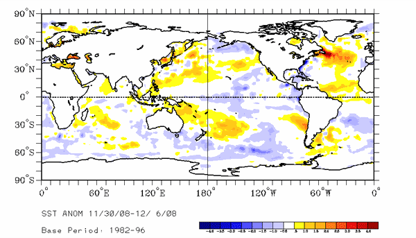
Sea-surface temperature satellite data from the national oceanic and atmospheric administration mirror jason sea-surface height measurements, clearly showing a cool pacific decadal oscillation pattern, as seen at:

sst-3.gif


http://www.cdc.noaa.gov/map/images/sst/sst.anom.gif .

"this multi-year pacific decadal oscillation 'cool' trend can cause la niña-like impacts around the pacific basin," said bill patzert, an oceanographer and climatologist at nasa's jet propulsion laboratory, pasadena, calif. "the present cool phase of the pacific decadal oscillation will have significant implications for shifts in marine ecosystems, and for land temperature and rainfall patterns around the pacific basin."

according to nathan mantua of the climate impacts group at the university of washington, seattle, whose research contributed to the early understanding of the pacific decadal oscillation, "even with the strong la niña event fading in the tropics last spring, the north pacific's sea surface temperature anomaly pattern has remained strongly negative since last fall. This cool phase will likely persist this winter and, perhaps, beyond. Historically, this situation has been associated with favorable ocean conditions for the return of u.s. West coast coho and chinook salmon, but it translates to low odds for abundant winter/spring precipitation in the southwest (including southern california)."

jason's follow-on mission, the ocean surface topography mission/jason-2, was successfully launched this past june and will extend to two decades the continuous data record of sea surface heights begun by topex/poseidon in 1992. The new mission has produced excellent data, which have recently been certified for operational use. Fully calibrated and validated data for science use will be released next spring.

Jpl manages the u.s. Portion of the jason-1 mission for nasa's science mission directorate, washington. Jpl is managed for nasa by the california institute of technology in pasadena.

For more information on nasa's ocean surface topography missions, visit http://sealevel.jpl.nasa.gov/ . To view the latest jason-1 data, visit http://sealevel.jpl.nasa.gov/science/jason1-quick-look/ .