Previsão e Seguimento de Furacões (Atlântico 2024)

WTNT61 KNHC 202150
TCUAT1

Hurricane Oscar Tropical Cyclone Update
NWS National Hurricane Center Miami FL AL162024
550 PM EDT Sun Oct 20 2024

...HURRICANE OSCAR MAKES LANDFALL ON THE NORTHERN COAST OF EASTERN
CUBA...


Satellite imagery and radar data indicate that Oscar has made
landfall in the Cuban province of Guantanamo near the city of
Baracoa at 550 PM EDT (2150 UTC). The maximum sustained winds are
near 80 mph (130 km/h) based on earlier Air Force Reserve Hurricane
Hunter observations. The latest minimum central pressure estimated
from the earlier reconnaissance data is 986 mb (29.12 inches).


SUMMARY OF 550 PM EDT...2150 UTC...INFORMATION
---------------------------------------------------
LOCATION...20.3N 74.4W
ABOUT 5 MI...10 KM ESE OF BARACOA
ABOUT 50 MI...80 KM E OF GUANTANAMO CUBA
MAXIMUM SUSTAINED WINDS...80 MPH...130 KM/H
PRESENT MOVEMENT...WSW OR 250 DEGREES AT 7 MPH...11 KM/H
MINIMUM CENTRAL PRESSURE...986 MB...29.12 INCHES

$$
Forecaster Bucci/Reinhart/Papin
 
Convecção diminuindo à entrada de Oscar em terra:

Oscar_goes16_ir_16L_202410202357.gif
 
Aviso das 15h:

Tropical Storm Oscar Discussion Number 10
NWS National Hurricane Center Miami FL AL162024
1100 AM EDT Mon Oct 21 2024

Surface observations and visible satellite imagery indicate that the center of Oscar, although not very easy to locate, is still moving over eastern Cuba this morning. Radar observations from Guantanamo Bay show that the inner core of the tropical cyclone has become severely disrupted. The system has continued to weaken while interacting with the very mountainous terrain, and the initial wind speed is estimated to have decreased to near 35 kt, although this may be generous.

---

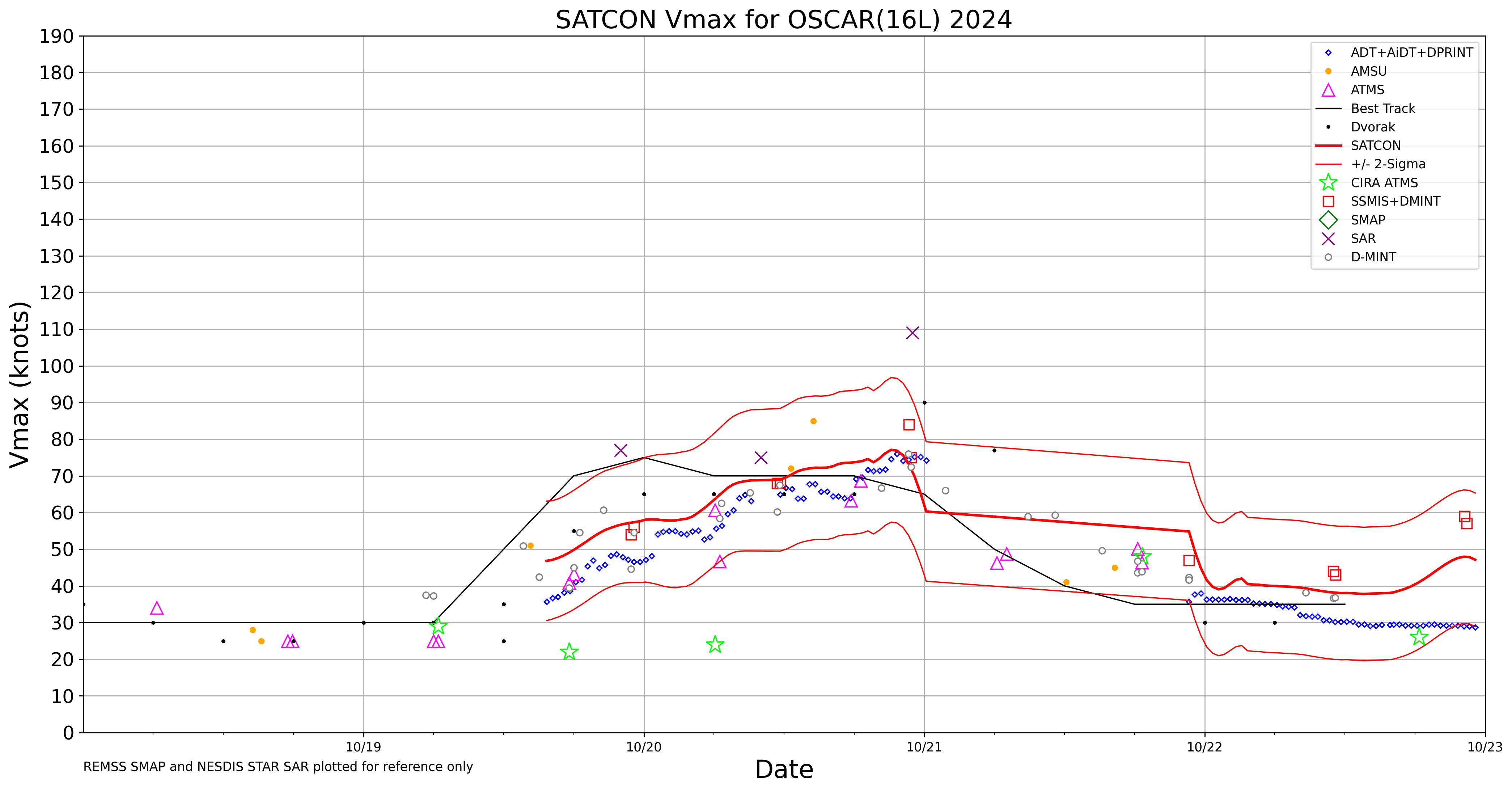
The CIMSS Satellite Consensus (SATCON) product blends tropical cyclone intensity estimates derived from multiple objective algorithms to produce an ensemble estimate of intensity for current tropical cyclones worldwide. The algorithm uses individual ADT, CIMSS AMSU, CIMSS SSMIS, CIMSS and CIRA ATMS intensity estimates utilizing a statistically-derived weighting scheme which maximizes/minimizes the strength/weaknesses of each technique to produce a consensus estimate of the current tropical cyclone intensity. The goal of this work is to produce an estimate of intensity that is superior to the individual components. Statistical verification of the method has shown it to be comparable in skill to the Dvorak Technique used by tropical cyclone warnings agencies. In some situations the algorithm can outfperform the Dvorak Technique.
202416L_wind.png


Dvorak:

16LP.GIF

Isso é a parte que 99% das pessoas não conhece. Observações de satélite até têm considerável variabilidade.

Observação dos >100 nós deve ter sido da interação com as montanhas.
 
Última edição:
Oscar parece estar mais a sul do que previsto?!?
O centro de Oscar é localizado ao nível da superfície (onde os ventos podem ser sentidos) e está sobre a zona Leste da ilha de Cuba, mas esta circulação está praticamente exposta e a convecção profunda bastante afastada para Sueste/Leste.

 
Esta é a situação atual no Atlântico:

nEjyBU6.png


Estão a ser monitorizadas 3 áreas:

I) Perturbação a W dos Açores com baixo potencial ciclónico (20%) em 2/7 dias;

3. North Atlantic:
Showers and thunderstorms have developed near the center of a
storm-force non-tropical low pressure area located about 550 miles
west of the western Azores. However, any additional development into
a subtropical or tropical cyclone is expected to be slow to occur as
the system moves eastward during the next few days. Additional
information on this system is available in High Seas Forecasts
issued by the National Weather Service.
* Formation chance through 48 hours...low...20 percent.
* Formation chance through 7 days...low...20 percent.


o4GLw92.png


II) Perturbação no Mar das Caraíbas (região SW) com baixo potencial ciclónico (10%) em 2 dias e moderado (60%) em 7 dias;

1. Southwestern Caribbean Sea:
A broad area of low pressure is likely to develop over the
southwestern Caribbean Sea during the next day or two. Gradual
development is possible thereafter, and a tropical depression could
form over the weekend or early next week while the system drifts
generally northward or northwestward over the central or western
Caribbean Sea. Regardless of development, locally heavy rains are
possible during the next several days across portions of the area
from Nicaragua southeastward and eastward to northern Colombia.
* Formation chance through 48 hours...low...10 percent.
* Formation chance through 7 days...medium...60 percent.


kW5Scbh.png


III) Perturbação nas Caraíbas (próxima a Porto Rico) com baixo potencial ciclónico (10%) em 2/7 dias.

2. Northeastern Caribbean Sea and Greater Antilles:
A trough of low pressure near Puerto Rico is producing widespread
cloudiness and showers over the Dominican Republic, Puerto Rico, the
Virgin Islands, the northern Leeward Islands, and the adjacent
waters of the Atlantic and the northeastern Caribbean. Slow
development of this system is possible during the next 2-3 days as
it moves west-northwestward near the Greater Antilles. After that
time, this system is expected to be absorbed into the low pressure
area over the Caribbean. Regardless of development, locally heavy
rains are possible during the next several days from the northern
Leeward Islands westward across Puerto Rico and Hispaniola to
eastern Cuba and the southeastern Bahamas.
* Formation chance through 48 hours...low...10 percent.
* Formation chance through 7 days...low...10 percent.


Xdtt6qC.png
 
Depressão Tropical 18 formou-se na AL97 e de seguida passou a Tempestade Tropical 'Rafael' .
Em 24 horas está prevista passar a furacão, e em 48 horas estar eminente o landfall como Cat.2 (85 nós) na zona ocidental de Cuba, atravessando a ilha passando perto de Havana.
Após emergir no Golfo vai travar o movimento para noroeste e perder gradualmente intensidade.
Apesar de manter aproximadamente o mesmo rumo, se atingir a costa do estado de Louisiana será como tempestade tropical, já após as 120 horas, segundo a previsão deste aviso #5.

TS-Rafael_20241104-21z_Aviso05_track.jpg


Tropical Storm Rafael Advisory Number 5
NWS National Hurricane Center Miami FL AL182024
400 PM EST Mon Nov 04 2024

...DEPRESSION STRENGTHENS INTO TROPICAL STORM RAFAEL...
...TROPICAL STORM CONDITIONS EXPECTED TO BEGIN IN JAMAICA
LATE TONIGHT...


SUMMARY OF 400 PM EST...2100 UTC...INFORMATION
----------------------------------------------
LOCATION...15.5N 76.7W
ABOUT 175 MI...280 KM S OF KINGSTON JAMAICA
ABOUT 395 MI...635 KM SE OF GRAND CAYMAN
MAXIMUM SUSTAINED WINDS...45 MPH...75 KM/H
PRESENT MOVEMENT...N OR 10 DEGREES AT 9 MPH...15 KM/H
MINIMUM CENTRAL PRESSURE...997 MB...29.44 INCHES
 
Última edição:
Rafael continua a trajectória segundo anteriores previsões, passou com o centro perto da Jamaica, ainda como tempestade tropical, e vai fazer landfall em Cuba aproximadamente na mesma zona anteriormente prevista, apenas um pouco mais longe de Havana mas com maior intensidade: é agora um Cat.2 85 nós e com previsão de intensificar-se até 90 nós antes de chegar a terra.
Ao voltar à água, já no Golfo recuperará quase a mesma intensidade. Nesta altura a previsão é de que a seguinte entrada em terra seria no Louisiana, como tempestade tropical.

Hu-Rafael_20241106-03z_Aviso10_track.webp


Hurricane Rafael Discussion Number 10
NWS National Hurricane Center Miami FL AL182024
1000 PM EST Tue Nov 05 2024

We have been fortunate to receive an abundance of in-situ data from
both an Air Force Reserve C-130 and a NOAA-P3 Hurricane Hunter
aircraft tonight. Their data indicated that Rafael had become a
hurricane just after 00 UTC with peak 750 mb flight level winds of
79 kt from the NOAA-P3 and 700 mb winds of 73 kt from the Air Force
C-130. On satellite imagery Rafael's structure continues to improve
with very cold deep convection near the center rotating around the
center. Radar reflectivity out of Grand Cayman Island also shows the
inner core continues to improve with a 10-15 n mi diameter eyewall,
though is still occasionally open on the southwest side. The initial
intensity is set to 70 kt, based on NOAA-P3 Tail Doppler Radar
velocities up to 85 kt in the NE eyewall boundary layer, which was
matched by an Air Force Recon dropsonde also launched in the NE
eyewall at 0025 UTC that had a 500 m layer average wind of 85 kt.

Rafael continues to move northwestward at 320/11 kt. A prominent
low- to mid-level ridge centered offshore of the Southeastern U.S.
should continue to steer the hurricane northwestward for the next
day or so. This track will lead to Rafael moving through the Cayman
Islands for the next few hours and then across the western portion
of Cuba during the afternoon on Wednesday. Thereafter, Rafael will
emerge into the southeastern Gulf of Mexico, where it is becoming
increasingly likely that the aforementioned ridging will begin to
build to the north of Rafael, leading to the hurricane turning more
west-northwestward and slowing down as it moves into the central
Gulf of Mexico. There have been notable changes in the global model
guidance today, with the GFS track shifting significantly to the
south and west over the past four cycles, closer to the ECMWF track.
This evolution is likely partially related to changes in the
upstream synoptic flow pattern, now showing a cutoff low digging
into the four corners region rather than being more progressive
moving eastward in the Great Plains. Such an evolution will allow a
narrow ridge to become oriented directly over Rafael, substantially
slowing its forward motion. Because it is becoming more evident the
ECMWF synoptic flow pattern may end up being correct, the NHC track
has been shifted leftward, especially beyond 48 h, compared to the
previous forecast track. At the very end of the forecast, Rafael
will likely become a shallow cyclone, drifting slowly northward in
the low-level flow.

Environmental conditions are very favorable for continued
intensification, and given that Rafael now possesses a tight inner
core and eyewall, rapid intensification seems likely. Strangely, the
HAFS models did not appear to initialize correctly at 18 UTC, and
were a good 5-10 mb too weak at 00 UTC tonight. Despite this, HAFS-B
raw model output shows Rafael becoming a category 2 hurricane before
moving over Cuba, and the NHC intensity forecast will now show
Rafael becoming a Category 2 hurricane in 12 h. It is also not
impossible Rafael becomes a major hurricane before impacting Cuba,
with at least one hurricane-regional model showing this possibility
this cycle (HMON). Rafael should briefly weaken over Cuba. After the
hurricane emerges into the Gulf of Mexico, the environment is not as
favorable as the northwestern Caribbean, but is also not especially
unfavorable from 24-48 h as it will remain over 27-28 C waters, and
only 10-15 kt of vertical wind shear. However, mid-level shear
begins to substantially increase after that time, and sea-surface
temperatures from wave drifters just north of Rafael's forecast
track are only 26-27 C. This one two negative punch will likely
begin to result in weakening, which should become more rapid towards
the end of the forecast period as very dry air over the western Gulf
of Mexico is likely to be ingested into the storm. The NHC intensity
forecast is at the upper-end of the guidance in the first 12 h, but
then falls closer to the HCCA consensus aid between 24-48 h, before
dropping into the middle of the intensity guidance envelope by the
end of the forecast. Rafael might be close to becoming post-tropical
as global model guidance suggests it may lose most of its remaining
convection in about 120 h.


Key Messages:

1. Rafael is forecast to be a hurricane when it passes near or over
the Cayman Islands during the next 12 hours, where damaging
hurricane-force winds, a dangerous storm surge, and destructive
waves are expected. Additional strengthening is expected before
Rafael reaches western Cuba and the Isle of Youth on Wednesday. A
hurricane warning is in effect for this region, where damaging
hurricane-force winds, life-threatening storm surge, and destructive
waves are also expected.

2. Tropical storm conditions are expected in the Lower and Middle
Florida Keys beginning Wednesday and Wednesday night.

3. It is too soon to determine what, if any, impacts Rafael could
bring to portions of the northern Gulf Coast. Residents in this
area should regularly monitor updates to the forecast.

4. Rafael will bring areas of heavy rain across portions of the
western Caribbean through early Thursday, including Jamaica and the
Cayman Islands, along with southern and western portions of Cuba.
Flash flooding and mudslides are possible along the higher terrain
in Jamaica and Cuba.


FORECAST POSITIONS AND MAX WINDS

INIT 06/0300Z 19.7N 80.4W 70 KT 80 MPH
12H 06/1200Z 21.2N 81.5W 90 KT 105 MPH
24H 07/0000Z 23.0N 83.2W 80 KT 90 MPH...ON THE N CUBA COAST
36H 07/1200Z 24.3N 84.6W 85 KT 100 MPH
48H 08/0000Z 24.8N 85.9W 85 KT 100 MPH
60H 08/1200Z 25.1N 87.4W 80 KT 90 MPH
72H 09/0000Z 25.4N 89.0W 75 KT 85 MPH
96H 10/0000Z 26.7N 91.2W 55 KT 65 MPH
120H 11/0000Z 27.9N 91.6W 35 KT 40 MPH

$$
Forecaster Papin

...HURRICANE RAFAEL PASSING THROUGH THE CAYMAN ISLANDS...
...FORECAST TO RAPIDLY INTENSIFY UNTIL LANDFALL IN WESTERN CUBA...


SUMMARY OF 1000 PM EST...0300 UTC...INFORMATION
-----------------------------------------------
LOCATION...19.7N 80.4W
ABOUT 60 MI...95 KM ENE OF GRAND CAYMAN
ABOUT 275 MI...440 KM SSE OF HAVANA CUBA
MAXIMUM SUSTAINED WINDS...80 MPH...130 KM/H
PRESENT MOVEMENT...NW OR 320 DEGREES AT 13 MPH...20 KM/H
MINIMUM CENTRAL PRESSURE...985 MB...29.09 INCHES
 
Última informação, das 18:00utc, confirma a subida de Rafael à categoria 3, mais um major hurricane nesta época.

BULLETIN
Hurricane Rafael Intermediate Advisory Number 12A
NWS National Hurricane Center Miami FL AL182024
100 PM EST Wed Nov 06 2024

...RAFAEL BECOMES A CATEGORY THREE HURRICANE AS IT NEARS THE
COAST OF WESTERN CUBA...
...EXPECTED TO BRING LIFE-THREATENING STORM SURGE, DAMAGING
HURRICANE-FORCE WINDS, AND FLASH FLOODING TO PORTIONS OF WESTERN
CUBA...


SUMMARY OF 100 PM EST...1800 UTC...INFORMATION
----------------------------------------------
LOCATION...22.0N 82.3W
ABOUT 40 MI...65 KM NE OF THE ISLE OF YOUTH
ABOUT 85 MI...135 KM S OF HAVANA CUBA
MAXIMUM SUSTAINED WINDS...115 MPH...185 KM/H
PRESENT MOVEMENT...NW OR 320 DEGREES AT 14 MPH...22 KM/H
MINIMUM CENTRAL PRESSURE...956 MB...28.23 INCHES


Note-se que Havana já está dentro da área de ventos com intensidade de tempestade tropical e a exacta localização da rota do centro do furacão é de certo modo irrelevante:

Hu-Rafael_20241106-18z_Aviso12A_track.webp