Será que haverá interacção entre as 2 tempestades, que partilham tal proximidade temporal e espacial?

Será que haverá interacção entre as 2 tempestades, que partilham tal proximidade temporal e espacial?
Se fôr, é bastante incompleto, mas parece haver uma atracção de Imelda pelo Humberto, para cúmulo do azar de Bermuda.
")
000
WTNT44 KNHC 021448
TCDAT4
Discussão pós-ciclone tropical Imelda número 24
Centro Nacional de Furacões do NWS Miami FL AL092025
11h00 AST qui, 02 de outubro de 2025
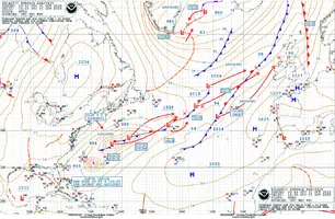
Imelda não é mais um ciclone tropical. Imagens de satélite visíveis e
campos do modelo global indicam que uma frente se estende até o centro de
o ciclone do leste-nordeste, enquanto outra característica frontal
desenvolveu-se ao sul do ciclone. Isso é consistente com
dados de microondas durante a noite que mostraram Imelda assumindo a aparência de
um ciclone ocluído, bem como tendências recentes de satélite que mostram
a convecção restante concentra-se principalmente ao longo dessas frentes.
Portanto, Imelda é classificado como um ciclone extratropical de 65 kt
esta manhã, e este será o último aviso do NHC sobre o sistema.
Imelda pós-tropical está correndo em direção ao leste-nordeste (075/25
kt) longe das Bermudas. Espera-se que o ciclone vire para nordeste
na sexta-feira, antes de uma depressão de nível superior amplificada sobre o
Atlântico Norte, depois volte para leste-nordeste por
Domingo dentro dos ventos de latitude média de oeste. A orientação da pista está em
acordo muito melhor do que ontem, e a previsão do NHC está próxima
o centro do envelope entre os auxílios HCCA e TVCA.
A força baroclínica do vale superior provavelmente causará a
ciclone permanecerá com uma grande força de tempestade baixa durante o fim de semana. Mesmo
embora se preveja que os ventos de pico diminuam gradualmente, uma grande
área de ventos de 34 e 50 kt criará condições marinhas perigosas
e grande ondulação que continuará afetando uma porção extensa de
Atlântico ocidental e central.
Informações adicionais podem ser encontradas nas Previsões de Alto Mar emitidas por
o Serviço Nacional de Meteorologia, sob o cabeçalho AWIPS NFDHSFAT1, WMO
cabeçalho FZNT01 KWBC, e online em
ocean.weather.gov/shtml/NFDHSFAT1.php
MENSAGENS PRINCIPAIS:
1. Os ventos fortes sobre as Bermudas diminuirão gradualmente hoje.
2. Espera-se que as ondas e as ondas altas de Imelda produzam
condições marinhas perigosas e correntes de retorno ao longo de grande parte do leste
Costa dos Estados Unidos e do Atlântico Ocidental durante os próximos
vários dias.
POSIÇÕES DE PREVISÃO E VENTOS MÁXIMOS
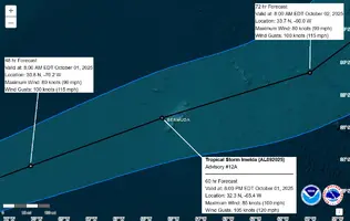
INIT 02/1500Z 33,2N 59,5W 65 KT 75 MPH...PÓS-TROPICAL
12H 03/0000Z 34,3N 55,0W 65 KT 75 MPH...PÓS-TROP/EXTRATROP
24H 03/1200Z 36,3N 51,4W 60 KT 70 MPH...PÓS-TROP/EXTRATROP
36H 04/0000Z 38,9N 49,1W 60 KT 70 MPH...PÓS-TROP/EXTRATROP
48H 04/1200Z 41,7N 47,6W 55 KT 65 MPH...PÓS-TROP/EXTRATROP
60H 05/0000Z 44,6N 44,6W 50 KT 60 MPH...PÓS-TROP/EXTRATROP
72H 05/1200Z 47,1N 40,1W 50 KT 60 MPH...PÓS-TROP/EXTRATROP
96H 06/1200Z 50.0N 30.5W 45 KT 50 MPH...PÓS-TROP/EXTRATROP
120H 07/1200Z...DISSIPULANTES
$$
Previsor Reinhart
518
WTNT45 KNHC 081452
TCDAT5
Tempestade Tropical Jerry Discussão Número 5
Centro Nacional de Furacões do NWS Miami FL AL102025
11h00 AST, quarta-feira, 8 de outubro de 2025
Jerry é um ciclone tropical cisalhado esta manhã, com o nível baixo
centro correndo à frente da convecção profunda associada. Apesar
nesta estrutura, uma aeronave NOAA Hurricane Hunter mediu um pico
Vento de 700 mb de 56 kt, e dados de radar Tail-Doppler mostraram ventos de
cerca de 75 kt a 500 metros acima da superfície. Mesmo usando um
fator de redução conservador para esses dados de rendimentos de 70 por cento
ventos de superfície de cerca de 50 kt. Dados recentes do ASCAT também confirmam que
a intensidade inicial é de cerca de 50 kt.
Jerry permanece em uma rápida trajetória oeste-noroeste (285/20 kt),
guiado por uma crista de nível baixo a médio ao norte. A crista apenas
estende-se até a longitude das Pequenas Antilhas, a oeste, e
espera-se que a fraqueza a oeste faça com que Jerry se volte
noroeste por 36 horas, com o centro potencialmente passando apenas
60-70 milhas náuticas a nordeste das Ilhas Leeward do norte. A trilha NHC
a previsão está ao longo do lado oeste do envelope de orientação durante
as primeiras 36 horas da previsão. Após 36 horas, a pista
a orientação tem se voltado um pouco para o leste, mostrando uma tendência mais acentuada
recurvatura sobre o Atlântico central resultante de uma grande
ciclone extratropical que se espera que se desenvolva perto dos EUA
costa leste no fim de semana.
Jerry está se movendo diretamente contra o vetor de cisalhamento analisado e
sondagens de modelos verticais sugerem que esta orientação pode não mudar
em breve. Está se tornando mais provável que Jerry possa permanecer um
tempestade tropical cisalhada para os próximos dias, e a intensidade
a orientação respondeu adequadamente. A previsão atualizada do NHC ainda
mostra a possibilidade de fortalecimento gradual ao longo de 60-72 horas,
no entanto o pico foi reduzido em cerca de 10 kt. Vale a pena
observando que apenas dois dos modelos confiáveis, o HWRF e
COAMPS-TC, ainda são superiores à previsão oficial, e o
Os auxílios de consenso do IVCN e do HCCA sugerem reduções adicionais na
a intensidade prevista pode ser possível em avisos futuros.
MENSAGENS PRINCIPAIS:
1. Jerry poderia trazer condições de tempestade tropical para partes do
norte das Ilhas de Sotavento na quinta-feira à noite e na quinta-feira à noite.
2. Chuvas fortes afetarão partes das Ilhas de Sotavento,
Ilhas Virgens Britânicas e Ilhas Virgens Americanas de quinta-feira a
Sábado de manhã, o que pode resultar em inundações repentinas, especialmente
em áreas de terreno íngreme.
POSIÇÕES DE PREVISÃO E VENTOS MÁXIMOS
INIT 08/1500Z 13,9N 52,7W 50 KT 60 MPH
12H 09/0000Z 14,7N 55,1W 55 KT 65 MPH
24H 09/1200Z 16,1N 58,2W 60 KT 70 MPH
36H 10/0000Z 17,9N 60,5W 60 KT 70 MPH
48H 10/1200Z 20,0N 61,9W 65 KT 75 MPH
60H 11/0000Z 22,5N 62,4W 70 KT 80 MPH
72H 11/1200Z 25,1N 62,2W 70 KT 80 MPH
96H 12/1200Z 29,6N 61,0W 70 KT 80 MPH
120H 13/1200Z 32,7N 56,9W 65 KT 75 MPH
$$
Previsor Berg
ZCZC MIATWOAT ALL
TTAA00 KNHC DDHHMM
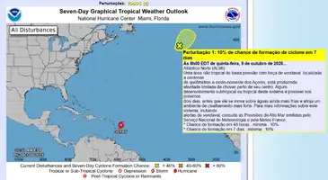
Perspectivas do Tempo Tropical
NWS National Hurricane Center Miami FL
800 AM EDT Qui 9 de out de 2025
Para o Atlântico Norte... Mar do Caribe e Golfo da América:
Sistemas Ativos:
O Centro Nacional de Furacões está emitindo alertas sobre a
Tempestade Tropical Jerry, localizada a algumas centenas de milhas a leste-sudeste das
Ilhas Leeward do norte.
1. Atlântico Norte (AL96):
Uma área não tropical de baixa pressão com força de vendaval localizada a várias
centenas de milhas a oeste-noroeste dos Açores está produzindo
atividade limitada de chuvas perto de seu centro. Algum
desenvolvimento subtropical ou tropical deste sistema é possível nos próximos um ou
dois dias antes que ele se mova sobre águas ainda mais frias e para um
ambiente de cisalhamento mais forte. Para mais informações sobre este sistema, incluindo
alertas de vendaval, consulte as Previsões de Alto Mar emitidas pelo
Serviço Nacional de Meteorologia e Meteo France.
* Chance de formação em 48 horas... baixa... 10 por cento.
* Chance de formação em 7 dias... baixa... 10 por cento.
As previsões de alto mar emitidas pelo Serviço Nacional de Meteorologia
podem ser encontradas no cabeçalho AWIPS NFDHSFAT1, cabeçalho WMO FZNT01
KWBC e online em ocean.weather.gov/shtml/NFDHSFAT1.php
As previsões de alto mar emitidas pela Meteo France podem ser encontradas no
cabeçalho WMO FQNT50 LFPW e disponíveis na web em
https://tgftp.nws.noaa.gov/data/raw/fq/fqnt50.lfpw..txt
Previsor Kelly