Previsão e Seguimento Furacões (Atlântico 2013)

Afgdr

Cumulonimbus
Registo
28 Set 2011
Mensagens
2,129
Local
Lagoa - São Miguel, Açores
jAcDvKq.gif


O Invest 98L está sob vigilância há alguns dias.


iE911Q8.gif


1. THUNDERSTORM ACTIVITY HAS BECOME MORE CONCENTRATED IN ASSOCIATION
WITH A LARGE LOW PRESSURE AREA LOCATED ABOUT 1100 MILES WEST-
SOUTHWEST OF THE CAPE VERDE ISLANDS. THERE IS POTENTIAL FOR A
TROPICAL DEPRESSION TO FORM IN THIS AREA DURING THE NEXT DAY OR SO
BEFORE UPPER-LEVEL WINDS BECOME LESS CONDUCIVE FOR TROPICAL CYCLONE
FORMATION. THIS SYSTEM HAS A HIGH CHANCE...60 PERCENT OF BECOMING
A TROPICAL CYCLONE DURING THE NEXT 48 HOURS...AND A HIGH CHANCE...
60 PERCENT...OF BECOMING A TROPICAL CYCLONE DURING THE NEXT 5 DAYS
WHILE IT MOVES WESTWARD TO WEST-NORTHWESTWARD AT 10 TO 15 MPH.


Estas são possíveis trajetórias deste sistema previstas pelos modelos.


FQtalat.gif


Afgdr

Cumulonimbus
Registo
28 Set 2011
Mensagens
2,129
Local
Lagoa - São Miguel, Açores
No ano passado, por esta altura, já tinham sido nomeadas 17 tempestades tropicais, das quais 9 tornaram-se furacões.

Desde 1 de Junho deste ano, foram nomeadas 11 tempestades tropicais, das quais 2 tornaram-se furacões.

Esta temporada tem sido fraca, em comparação a anos anteriores.


Aqui estão alguns artigos da internet sobre este assunto.


The 2013 Atlantic Hurricane Season Has Been Eerily Quiet; But Why?

Posted: 10/16/2013 5:55 pm EDT | Updated: 10/17/2013 9:13 am EDT


n-HURRICANE-NASA-large570.jpg

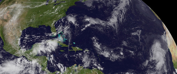
In this handout satellite image provided by the National Oceanic and Atmospheric Administration (NOAA) and the National Aeronautics and Space Administration (NASA), hurricane Humberto (R) forms as a category one on September 11, 2013 in the far eastern Atlantic Ocean. Humberto was the first hurricane of the 2013 season. (Photo by NOAA/NASA GOES Project via Getty Images) | Getty


From Climate Central's Andrew Freedman:

Nearly one year after Hurricane Sandy ravaged the East Coast, the 2013 Atlantic Hurricane Season has not produced a single land-falling hurricane in the U.S. Instead of having above-average storm activity, as the seasonal hurricane outlooks unanimously called for, the season has been quiet — notable for its inactivity.

The tropical season doesn’t officially end until November 30, but it would take a barrage of late-season storms to bring the season up to average levels, let alone above average, something that forecasters say is unlikely.

“It’s not only quiet, but it’s got the potential to be near record quiet for the Atlantic Basin,” Chris Landsea, a meteorologist at the National Hurricane Center in Miami, said.

So far, there have been just 11 named storms, two of which have been hurricanes, and none that have been major hurricanes.

While pre-season outlooks rarely, if ever, have pinpoint accuracy, they don’t usually miss by such a large margin. In May, the National Oceanic and Atmospheric Administration (NOAA) projected that there would likely be between 13 and 20 named storms (with sustained winds of at least 39 mph). Of those storms, NOAA projected that between seven and 11 would achieve hurricane status (winds of at least 74 mph); and that three or four would become major hurricanes of category 3, 4 or 5 (winds of at least 111 mph).

By one measure, 2013 so far ranks as the 7th quietest season in the past 70 years. That measure uses an index known as Accumulated Cyclone Energy, which incorporates how many storms formed, how long they lasted, and how strong they became. If no additional storms were to form before the end of the season, 2013 would be the 4th quietest.

There has not been a major hurricane in either the North Atlantic Basin or the eastern Pacific this year, something that hasn’t happened since 1968, according to Philip Klotzbach, a hurricane researcher and seasonal forecaster at Colorado State University.

Subsidence and the Sahara

The scant number of storms is surprising given some of the favorable conditions that exist that would normally fuel tropical cyclones. The ocean waters throughout the North Atlantic are warmer than average, the trade winds are lighter, and there is no El Niño event in the Pacific to ramp up high altitude winds that can tear nascent storms apart.

Forecasters say that three main features loom large for the inactivity: large areas of sinking air, frequent plumes of dry, dusty air coming off the Sahara Desert, and above-average wind shear. None of those features were part of their initial calculations in making seasonal projections. Researchers are now looking into whether they can be predicted in advance like other variables, such as El Niño and La Niña events.
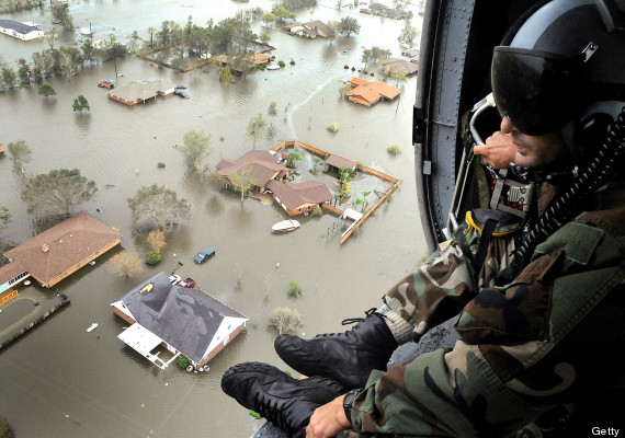

o-HURRICANE-IKE-TEXAS-570.jpg


hurricane ike texas
In this handout provided by the U.S. Air Force, an Air Force Reserve pararescueman from the 920th Rescue Wing scans the landscape of Nederland, Texas in the aftermath of Hurricane Ike, 13 September 2008. (Photo by Paul Flipse/US Air Force via Getty Images)

Brian McNoldy, a senior research associate at the University of Miami, said that across the Atlantic this season “you had air sinking through a pretty large depth of the atmosphere.” Sinking air inhibits storm formation by causing air to become drier and more stable, thereby stunting the growth of thunderstorms that require moist, unstable air in order to thrive.

Tropical weather systems depend on a plentiful supply of warm, moist air to form and intensify, and when these storms ingest exceptionally dry air, as many of the storms have this year, they can choke to death in a matter of hours or days. For example, Tropical Storm Karen formed in the Gulf of Mexico, where landfall in the U.S. or Mexico is virtually assured, but died before reaching land because of the presence of dry air and strong wind shear.

Some of the dry air across the Atlantic Basin came from large areas of dusty air that originated in the scorching Sahara Desert. However, such outbreaks of dusty air are fairly typical during hurricane season. What has been unusual has been the broad expanse of sinking and drying air throughout the North Atlantic basin, McNoldy said.


o-TROPICAL-STORM-KAREN-570.jpg


This season, the dry air “made a huge difference” and “squashed all the other factors that looked good,” he said.

Klotzbach said the area where most tropical storms and hurricanes form had the driest mid-to-lower atmospheric conditions during the Aug. 1 to Sept. 25 period since reliable records began in 1970.

In addition to the dry air, Landsea and Klotzbach pointed to above-average wind shear as another key reason. Wind shear is the difference in wind speed and direction between the ocean surface and the mid-to-upper atmosphere. Strong shear can knock storms off balance, essentially tearing them apart and allowing dry air to enter their circulation.

Landsea said that NOAA’s seasonal outlooks focused on the other pieces of the puzzle that argued in favor of an above average to average season, namely the absence of El Nino and the presence of warm sea surface temperatures. The seasonal outlook won’t be correct every time, Landsea said.

Klotzbach, who along with William Gray pioneered the art of forecasting the severity of hurricane seasons, said future outlooks will need to incorporate more variables.

“We will be looking at ways to be able to incorporate more moisture data into our models, in hopes to not make a similar mistake in future years,” he said in an email interview.

Record Major Hurricane Drought Continues

The absence of a major hurricane in the U.S. this season means the continuation of a record-long streak. On Oct. 24, it will be exactly 8 years since the last major hurricane of Category 3 strength or greater made landfall. Scientists fear this streak of good luck is leading to more severe cases of “hurricane amnesia,” which can complicate emergency preparation efforts the next time a monster storm threatens.

“When it doesn’t happen often you certainly become a little more lax,” McNoldy said, noting that in the 8 years since Hurricane Wilma struck Florida, tens of thousands of people have moved to the Sunshine State, many of whom have never before experienced a major hurricane. These residents, McNoldy said, may be less willing to evacuate their homes before the next major storm strikes.

“People who have never experienced it . . . don’t really know what they’re in for,” McNoldy said.

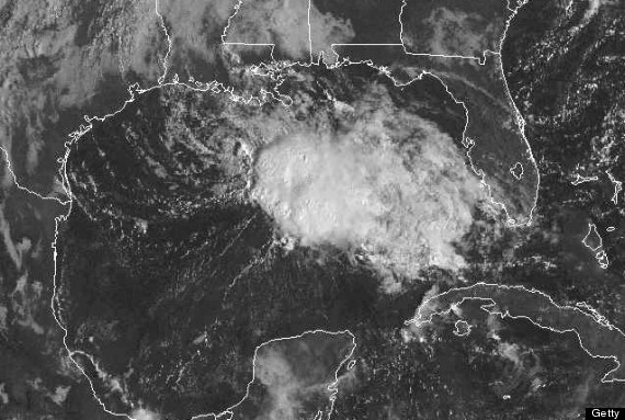
tropical storm karen
In this GOES satellite handout photo provided by National Oceanic and Atmospheric Administration (NOAA), Tropical Storm Karen churns in the Gulf of Mexico on October 05, 2013. (Photo by NOAA via Getty Images)

Klotzbach said the “fear of complacency” grows as the major hurricane gap lengthens. “One statistic that people should remember is that on average, about 1 in every 3 major hurricanes makes landfall at major hurricane strength (in the U.S.)” he said. Klotzbach noted that since 2005, 22 major hurricanes formed in the Atlantic, yet none of them made landfall in the U.S. as major hurricanes.

Even without a major hurricane reaching land, the U.S. has seen its fair share of damaging storms in recent years. Hurricane Ike devastated the Galveston, Texas area in 2008 as a strong Category 2 storm, and Sandy was one of the strongest and most destructive storms to ever strike the Jersey Shore.

“I think anybody living along the Jersey coast or Long Island or in New York City would attest that they had a major event even though it wasn’t a major hurricane,” Landsea said.

http://www.huffingtonpost.com/2013/10/16/2013-atlantic-hurricane-season-_n_4110279.html


_______________________________________


2013 Atlantic hurricane season weaker than expected

October 15, 2013 | By Zach Rausnitz


This year's Atlantic hurricane season is on pace to see fewer hurricanes than expected and fewer than a typical season.


hurricane-ingrid-mexico.jpg


Twelve named storms, only two of which became hurricanes, have occurred so far. Neither hurricane reached Category 3, the point at which a storm is considered a major hurricane. The National Oceanic and Atmospheric Administration had predicted three to six major hurricanes this season.

Atlantic hurricane season lasts from June 1 to Nov. 30, and an average season sees 12 named storms, six hurricanes and three major hurricanes.

In a recent survey on Federal IT Reform, Senior government IT executives laid out their vision for the coming year, detailing challenges and identifying priorities. To read more about these timely results click here to download the summary today.
Sign up for our FREE newsletter for more news like this sent to your inbox!
By mid-October of 2012, there had been 17 named storms, nine of which were hurricanes, well ahead of this year's pace. Hurricane Sandy, last year's most powerful and destructive storm, did not occur until late October, but hurricanes are uncommon in November. In 2011 and 2012 combined, the month of November had one tropical storm and no hurricanes.

The 2012 Atlantic hurricane season finished with 19 named storms, 10 of which became hurricanes. Only two of those hurricanes reached Category 3--Sandy and Michael. Sandy, which was a post-tropical cyclone by the time it made landfall, caused tens of billions of dollars in damage and killed 147 people. Hurricane Michael never made landfall.

Isaac, while only a Category 1 hurricane, caused more than $2 billion in damage and killed 34 people.

This year, Hurricane Humberto was the first hurricane, reaching Category 1 status in September but never making landfall.

Hurricane Ingrid, which also topped out at Category 1, struck Mexico in September, killing dozens in conjunction with another storm.

For more:
- go to the NHC archive for the 2013 Atlantic hurricane season


http://www.fiercehomelandsecurity.c...c-hurricane-season-weaker-expected/2013-10-15


_______________________________________


Last Gasp for the Atlantic Hurricane Season

By Alex Sosnowski, Expert Senior Meteorologist
October 18, 2013; 6:36 PM


The area that has bred the majority of tropical storms during the 2013 Atlantic season may have a couple more tricks up its sleeve before the season comes to a close.
The western Caribbean and southwestern Gulf of Mexico are likely candidates for near-continent tropical storm formation in the coming weeks.
As large high pressure areas begin to build southeastward from Canada and across the eastern United States, the flow of air around these fair weather systems may help to spin up tropical systems farther south.


650x366_10181529_hd27.jpg


According to AccuWeather Hurricane Expert Dan Kottlowski, "It is not uncommon to get a tropical system to form south of a large area of high pressure."
Tropical systems would have to form very far south in this case.
The advancing areas of chilly high pressure over the next few weeks will also greatly lower the risk of powerful storms tracking very far to the north, such as the central Gulf Coast and much of the Atlantic Seaboard.


650x366_10181426_hd26.jpg


"The combination of cool air, cooling waters and disruptive winds produced by the high pressure area would tend to limit the strength of any system," Kottlowski said.
Areas to watch closely during the upcoming pattern expected from later next week into November for tropical storm or hurricane impact would be from the Florida Peninsula southwestward to southern Mexico, Central America and the islands around the western part of the Caribbean.

There have been 11 systems that have reached at least tropical storm strength this season with Humberto and Ingrid being the only systems to reached Category 1 hurricane status.
Including Tropical Depression 8, there have be six tropical systems originating from the general area of the western Caribbean to the southern Gulf.
Officially, hurricane season continues until the end of November.
According to the National Oceanic and Atmospheric Administration, from 1851 to 2012, on average there have been one to two tropical storms and about one hurricane from late October through the end of November. The total seasonal average number of tropical storms in the Atlantic is 10 with six hurricanes.
Long Range Weather Expert Paul Pastelok stated during an interview this past summer that the hurricane season may continue late this year with a tropical storm here and there well into November, with the greatest risk being flooding rainfall.
Part of the old moisture from Karen may have played a role in flooding rainfall in parts of southern Pennsylvania and northern Maryland late last week. Close to 10 inches of rain fell on Harrisburg, Pa., in a little over 24 hours.
Persistent dry air and rounds of disruptive winds have played a significant role in reducing the number of hurricanes and the strength of the same this season.
The Atlantic Season behaved like an El Niño year, yet all data suggest that water temperatures over much of the tropical Pacific were near average, suggesting a neutral pattern.
During El Niño, tropical Pacific waters are warmer than normal. This tends to shift disruptive winds southward over eastern North America and much of the Atlantic. These winds tend to inhibit tropical storm formation and limit the strength of tropical systems in general.
"There is something else in addition to dry air, wind shear and tropical water temperatures, playing a role during the low hurricane seasons that we know little about and meteorologists have to study more," Kottlowski stated.


http://www.accuweather.com/en/weather-news/last-gasp-for-the-atlantic-hur/18980610


_______________________________________


What 50 Years of Hurricane Data Still Hasn't Told Us


JohnNelsonIDVsolutions.jpg


BY MAX KNOBLAUCH
5 DAYS AGO


In case you haven't noticed, the 2013 Atlantic hurricane season has been pretty tame, thank goodness.

Given that roughly 60% of Atlantic tropical cyclones since 1950 have occurred in August and September, and that we're coming off of three seasons with twelve, seven and ten hurricanes, respectively, this year's measly two hurricanes is puzzling.

"This year we didn't even get a category two hurricane," says Dr. Jeff Masters, director of meteorology at Weather Underground. "That's really rare. You have to go back to, I think, 1968 to see a season when we didn't even have a category two hurricane. Very unusual."


NOAA-hurricane-season.jpg
Image: National Hurricane Center


According to many meteorologists, this annual fluctuation is attributed to natural variability. Dry, sinking air and strong upper level winds are the likely culprit behind this season's abnormally low numbers, but hurricane climatologists caution the public from drawing too many conclusions from a single year.

James Elsner, Ph.D, professor of hurricane climatology at Florida State University, elaborates. "Not to say that, given we have a low season, we shouldn't look for why, but there is this large variability that we just have to accept as part of the way nature works," Elsner tells Mashable. "In either case, you can conclude incorrectly that the sky is falling or incorrectly that nothing is happening." "In either case, you can conclude incorrectly that the sky is falling or incorrectly that nothing is happening."

To see what's really happening with hurricanes, you have to look at the bigger picture.

"We've observed an increase in the length of the Atlantic hurricane season in recent decades," says Masters. "Things are beginning earlier and ending later, and that's been correlated to record sea surface temperatures, no surprise."

The Intergovernmental Panel on Climate Change (IPCC), the leading international body for the assessment of climate change, confirmed the increase in ocean temperatures in its Fifth Assessment Report released in June. From the summary:

Ocean warming dominates the increase in energy stored in the climate system, accounting for more than 90% of the energy accumulated between 1971 and 2010 (high confidence). It is virtually certain that the upper ocean (0−700 m) warmed from 1971 to 2010, and it likely warmed between the 1870s and 1971.

So what could warming oceans mean for season length? According to a 2008 paper by Dr. Jim Kossin of the National Climatic Data Center, the beginning and end of hurricane season lengthened by 20 days, per degree Celsius of sea surface temperature increase — though he notes the uncertainty in these relationships is high.

The graph below expands upon this warming trend.


sea-surface-temp-NOAA.jpg
Image: NOAA


Warming oceans, says Masters, also work to increase the intensity and severity of storms.

Hurricanes are heat engines, explains Masters. They use energy from the ocean and convert it to wind. If the world's oceans are warmer, potentially, the maximum strength of a storm increases, too. "In a future where the oceans are three or four degrees warmer, every now and then you're gonna get an off-the-charts hurricane like we've never seen before." "In a future where the oceans are three or four degrees warmer, every now and then you're gonna get an off-the-charts hurricane like we've never seen before."

Aside from season length and storm strength, the number of named storms in the Atlantic has also increased over a relatively short time period.

"We certainly — over the last 50 years and especially since about the mid-'90s — have seen an increase in the frequency of tropical storms and hurricanes in the Atlantic," says Elsner.

While our technology and ability to detect storms via satellite has certainly improved, Masters believes there's been a real increase as well.


IDV-solutions-full.jpg
Image: John Nelson, IDV Solutions


Natural variability and recent advancements in our observational capabilities have made the link between human-induced climate change and fluctuating hurricane patterns a controversial one. Because trends in data only become discernible with time, Masters believes it will be five or 10 years before we have a firm handle on what's going on.

However, he has his own theory: "We've had way too many of these one in 100, one in 500, one in 1,000 year type events to be a coincidence, in my view. There has to be something up," he says. "We need to expect the unexpected in the future. We're just going to have to hang on for the ride and see what happens."


http://mashable.com/2013/10/13/hurricane-patterns-history/
 
  • Gosto
Reactions: CptRena

Felipe Freitas

Cumulonimbus
Registo
11 Fev 2012
Mensagens
3,766
Local
Florianópolis, Santa Catarina, Brasil
Uma área de baixa pressão tem atualmente 10% de chances de se tornar um ciclone tropical ou subtropical nas próximas 48 horas e 50% nos próximos 5 dias.
Devido ao cisalhamento não ser muito alto ( ~20 knots) e a temperatura da água nesta região ainda estar um pouco quente, o ambiente será favorável, mesmo que pouco ao desenvolvimento do sistema.

0GGFShD.gif


1. A NON-TROPICAL LOW PRESSURE SYSTEM IS GRADUALLY DEVELOPING OVER THE
CENTRAL ATLANTIC OCEAN SEVERAL HUNDRED MILES TO THE SOUTHEAST OF
BERMUDA. ENVIRONMENTAL CONDITIONS COULD BECOME CONDUCIVE FOR THIS
SYSTEM TO GRADUALLY ACQUIRE SUBTROPICAL OR TROPICAL CHARACTERISTICS
LARER THIS WEEKEND OR EARLY NEXT WEEK AS THE LOW MOVES
NORTHWESTWARD TO NORTHWARD. THIS SYSTEM HAS A LOW CHANCE...10
PERCENT...OF BECOMING A SUBTROPICAL OR TROPICAL CYCLONE DURING THE
48 HOURS...AND A MEDIUM CHANCE...50 PERCENT...OF BECOMING A
SUBTROPICAL OR TROPICAL CYCLONE DURING THE NEXT FIVE DAYS.
 

FJC

Cumulus
Registo
14 Dez 2009
Mensagens
324
Local
Marinha Grande
Boa Tarde!

Grande sistema em formação. Subtropical, certo? Embora esteja a fechar no centro da depressão.

1. DURING THE PAST SEVERAL HOURS...SHOWERS AND THUNDERSTORMS HAVE
INCREASED AND BECOME MORE CONCENTRATED NEAR THE WELL-DEFINED CENTER
OF A NON-TROPICAL LOW PRESSURE SYSTEM...LOCATED ABOUT 740 MILES
EAST-SOUTHEAST OF BERMUDA. SATELLITE AND SHIP DATA INDICATE THAT
THIS SYSTEM IS PRODUCING GALE-FORCE WINDS...AND ENVIRONMENTAL
CONDITIONS ARE BECOMING MORE CONDUCIVE FOR A SUBTROPICAL OR
TROPICAL STORM TO FORM LATER TODAY OR ON TUESDAY. THIS SYSTEM HAS A
HIGH CHANCE...90 PERCENT...OF BECOMING A SUBTROPICAL OR TROPICAL
CYCLONE DURING THE NEXT 48 HOURS....AND A HIGH CHANCE...90
PERCENT...OF BECOMING A SUBTROPICAL OR TROPICAL CYCLONE DURING THE
NEXT 5 DAYS WHILE THE SYSTEM MOVES NORTHWARD TO NORTHWESTWARD AT
AROUND 10 MPH. ADDITIONAL INFORMATION ON THIS SYSTEM CAN BE FOUND
IN HIGH SEAS FORECASTS ISSUED BY THE NATIONAL WEATHER SERVICE.


Uploaded with ImageShack.us
 

Afgdr

Cumulonimbus
Registo
28 Set 2011
Mensagens
2,129
Local
Lagoa - São Miguel, Açores
A Tempestade Subtropical Melissa fortaleceu um pouco e agora tem ventos máximos sustentados de 104/105 km/h e poderá tornar-se uma tempestade (ciclone) tropical nas próximas horas. Deverá passar a Norte dos Açores.


FWFTewV.jpg


d8xVOLn.jpg


4xRhrGH.gif


Estas são as possíveis trajetórias previstas por alguns modelos.


cBzlsZF.gif
 

FJC

Cumulus
Registo
14 Dez 2009
Mensagens
324
Local
Marinha Grande
Boa tarde!

Parece que a Melissa já apresenta características Tropicais, com a circulação fechada em volta do centro e convesão. Corrijam-me se estiver errado!

No aviso número 8 já falavam nessa possibilidade:

SUBTROPICAL STORM MELISSA DISCUSSION NUMBER 8
NWS NATIONAL HURRICANE CENTER MIAMI FL AL142013
500 AM AST WED NOV 20 2013

A SMALL AREA OF DEEP CONVECTION HAS BEEN PERSISTING NEAR AND TO THE
NORTH OF THE CENTER OF MELISSA SINCE ABOUT 0400 UTC. THIS SUGGESTS
THAT MELISSA COULD BE NEARING THE EXPECTED TRANSITION FROM A
SUBTROPICAL TO A TROPICAL STORM
. NONETHELESS...THE STRENGTH OF THE
CYCLONE HAS NOT CHANGED...BASED ON A SATELLITE INTENSITY ESTIMATE
FROM TAFB AND EARLIER ASCAT DATA. THE ENVIRONMENTAL CONDITIONS ARE
NOT CONDUCIVE FOR STRENGTHENING...AS MELISSA IS EXPECTED TO MOVE
OVER PROGRESSIVELY COLDER WATER AND REMAIN IN AT LEAST MODERATE
SOUTH-SOUTHWESTERLY SHEAR. THEREFORE...THE NHC FORECAST CALLS FOR
LITTLE CHANGE IN INTENSITY DURING THE NEXT FEW DAYS...FOLLOWING THE
GFS AND ECMWF GUIDANCE. POST-TROPICAL TRANSITION IS EXPECTED TO
OCCUR IN 24 TO 36 HOURS...WHEN THE CYCLONE IS FORECAST TO BE OVER
SEA SURFACE TEMPERATURES BELOW 20C.


Uploaded with ImageShack.us
 

FJC

Cumulus
Registo
14 Dez 2009
Mensagens
324
Local
Marinha Grande
Entretanto o NOAA já classificou Melissa de Tempestade Tropical, mas pelo que se pode por pouco tempo.

TROPICAL STORM MELISSA DISCUSSION NUMBER 9
NWS NATIONAL HURRICANE CENTER MIAMI FL AL142013
1100 AM AST WED NOV 20 2013

MELISSA HAS MADE THE EXPECTED TRANSITION TO TROPICAL STORM STATUS.
DEEP CONVECTION HAS NOW DEVELOPED NEAR THE CENTER...THE CLOUD
PATTERN EXHIBITS CURVED BANDS WITH UPPER-LEVEL ANTICYCLONIC
OUTFLOW...AND THE UPPER-LEVEL LOW OVER MELISSA HAS WEAKENED.
DVORAK ESTIMATES FROM BOTH TAFB AND SAB ALSO CHANGED FROM
SUBTROPICAL TO TROPICAL STATUS AND SUPPORT AN INITIAL INTENSITY OF
50 KNOTS. MELISSA IS MOVING OVER PROGRESSIVELY COLDER WATERS AND
EMBEDDED WITHIN STRONG SHEAR. THEREFORE...LITTLE CHANGE IN
INTENSITY IS ANTICIPATED TODAY...BUT MELISSA SHOULD BEGIN TO
GRADUALLY ACQUIRE EXTRATROPICAL CHARACTERISTICS IN ABOUT 24 TO 36
HOURS.

Julgo que esta seja uma nova trajectória, que se pode ver no modelo GFS.


Uploaded with ImageShack.us
 

stormy

Super Célula
Registo
7 Ago 2008
Mensagens
5,149
Local
Lisboa
Deverá chegar aos Açores como TS ou TD...vamos ver como ela interage com a perturbação polar que sairá do Canadá nas próximas horas.

A interacção com sistemas extratropicais pode por vezes fortalecer os ciclones topicais, ou causar a transição extratropical sem que estes percam muita intensidade durante o processo.

Outras vezes tal não acontece...depende muito da dinâmica que se gera na interacção dos dois sistemas em causa.
 

Afgdr

Cumulonimbus
Registo
28 Set 2011
Mensagens
2,129
Local
Lagoa - São Miguel, Açores
DY76pla.gif


Está sob vigilância um novo sistema, o Invest 90L.


hqUy2FC.gif


1. A NON-TROPICAL LOW PRESSURE SYSTEM IS GRADUALLY DEVELOPING OVER THE
EASTERN ATLANTIC OCEAN ABOUT MIDWAY BETWEEN THE LESSER ANTILLES AND
THE AZORES. ALTHOUGH THE LOW COULD ACQUIRE SUBTROPICAL
CHARACTERISTICS DURING THE NEXT DAY OR TWO...ENVIRONMENTAL
CONDITIONS ARE EXPECTED TO BECOME UNFAVORABLE FOR DEVELOPMENT AFTER
THAT TIME. THIS SYSTEM HAS A LOW CHANCE...20 PERCENT...OF BECOMING
A SUBTROPICAL CYCLONE DURING THE NEXT 48 HOURS...AND A LOW
CHANCE...20 PERCENT...OF BECOMING A SUBTROPICAL CYCLONE DURING THE
NEXT 5 DAYS WHILE IT MOVES GENERALLY NORTHEASTWARD. ADDITIONAL
INFORMATION ON THIS SYSTEM CAN BE FOUND IN HIGH SEAS FORECASTS
ISSUED BY THE NATIONAL WEATHER SERVICE.
 

Afgdr

Cumulonimbus
Registo
28 Set 2011
Mensagens
2,129
Local
Lagoa - São Miguel, Açores
A temporada de furacões termina hoje, 30 de Novembro.

O Invest 90L pode vir a tornar-se ainda uma tempestade subtropical ou tropical.


7aj8ZN4.jpg


Ib13OXm.jpg


yeXeIm0.jpg


NjfumfS.jpg


Estas são possíveis trajetórias deste sistema previstas pelos modelos.


D1dJESk.gif
 

Afgdr

Cumulonimbus
Registo
28 Set 2011
Mensagens
2,129
Local
Lagoa - São Miguel, Açores
Já terminou a temporada de furacões no Atlântico...

Nesta temporada, que iniciou-se a 1 de Junho deste ano, formaram-se 13 tempestades tropicais, das quais 2 tornaram-se furacões.

Para além disso, os furacões não ultrapassaram a categoria 1.

Estava previsto que esta temporada seria acima do normal, situação que não se veio a verificar.

Por estas razões, esta temporada fica marcada por ser uma das que teve o menor número de furacões, por não se terem formado major hurricanes, isto é, furacões de categoria igual ou superior a 3 e por ser uma das mais calmas.