Previsão e Seguimento Furacões (Atlântico 2017)
- Thread starter Felipe Freitas
- Data de início
-
O novo portal está no ar! Novos meteogramas, cartas, e mais. Mais informações neste tópico
Seguimento Meteorológico: Litoral Norte | Interior Norte e Centro | Litoral Centro | Sul | Açores e Madeira | Livre
Previsões: Curto e médio prazo: até 2 semanas | Longo prazo: mensal e sazonal (Regras e links úteis nos 1ºs posts)
Facebook | Avisos IPMA/Alertas ANEPC
You are using an out of date browser. It may not display this or other websites correctly.
You should upgrade or use an alternative browser.
You should upgrade or use an alternative browser.

Excetuando alguma surpresa anómala, Setembro deve acabar com 13 tempestades nomeadas, 4 furacões e 4 furacões Major.
Lee, aviso 34. Mais uma reviravolta.
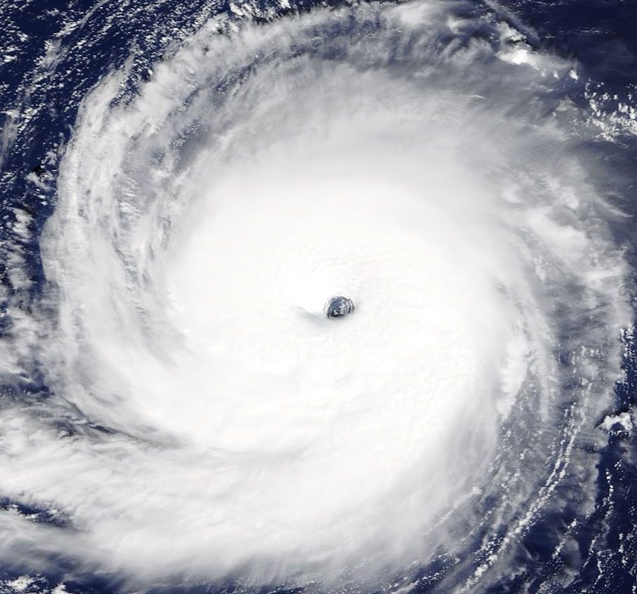
Lee is small but impressive hurricane this morning with a well-defined eye on visible satellite images. Satellite intensity estimates are a little higher and support an initial wind speed of at least 90 kt. Further strengthening is possible for the next day or so while Lee continues moving over warm waters with relatively light shear. Most of the guidance shows Lee getting a bit stronger, and the cyclone stands some chance of becoming a major hurricane within the next 24 hours or so. The official forecast is raised from the previous one, and is on the high side of the guidance.
FORECAST POSITIONS AND MAX WINDS
INIT 26/1500Z 29.9N 53.7W 90 KT 105 MPH
12H 27/0000Z 30.0N 55.1W 95 KT 110 MPH
24H 27/1200Z 30.6N 56.2W 95 KT 110 MPH
36H 28/0000Z 31.7N 56.8W 90 KT 105 MPH
48H 28/1200Z 33.3N 56.7W 85 KT 100 MPH
Na nova previsão o Lee fica a 1 nó de se tornar num cat. 3 e no 5º furacão Major da temporada.
luismeteo3
Furacão
luismeteo3
Furacão
Maria deve ser rebaixada a tempestade tropical hoje.
Maria acumulou 40 de ACE, tornando assim 2017 a primeira temporada da história com três ciclones no mesmo ano acumulando igual ou maior a este valor.
Irma acumulou quase 70, segundo maior valor atrás de Ivan, 2004 e José cerca de 42.
ACE de 2017 está em 191 e poderia chegar a 200 até final de Setembro.
Esse foi Setembro mais ativo da história em relação ao ACE, superando 2004.
Lee agora categoria 2 deve se fortalecer mais um pouco.
Lee, aviso 35. C2 muito forte e a 1 nó de se tornar major.
Satellite images indicate that the cloud-top temperatures in the eyewall of Lee have cooled this afternoon, with about the same warm temperatures in the eye. This indicates Lee remains on a strengthening trend, and the initial wind speed is set to 95 kt, near the CIMSS Advanced Dvorak Technique figure. Lee has about 24 hours to intensify before shear increases and water temperatures begin to cool. Most of the guidance now show Lee becoming a major hurricane, and the official forecast follows suit.
FORECAST POSITIONS AND MAX WINDS
INIT 26/2100Z 29.9N 54.6W 95 KT 110 MPH
12H 27/0600Z 30.0N 55.9W 100 KT 115 MPH
24H 27/1800Z 31.0N 56.9W 95 KT 110 MPH
luismeteo3
Furacão
...LEE STILL INTENSIFYING, FORECAST TO BECOME A MAJOR HURRICANE BY EARLY WEDNESDAY...
5:00 PM AST Tue Sep 26
Location: 29.9°N 54.6°W
Moving: W at 8 mph
Min pressure: 971 mb
Max sustained: 110 mph
5:00 PM AST Tue Sep 26
Location: 29.9°N 54.6°W
Moving: W at 8 mph
Min pressure: 971 mb
Max sustained: 110 mph
NHC espera que Lee se torne o quinto grande furacão de 2017 até amanhã.
Caso se confirme, irá faltar apenas 2 grandes furacões para alcançar 1961 e 2005.
Caso se confirme, irá faltar apenas 2 grandes furacões para alcançar 1961 e 2005.
luismeteo3
Furacão
luismeteo3
Furacão
luismeteo3
Furacão
luismeteo3
Furacão
lserpa
Cumulonimbus
Maria está decapitada e mesmo assim consideram-lhe como furacão! Americanisses? Lolol
Enviado do meu iPhone usando Tapatalk
Enviado do meu iPhone usando Tapatalk
luismeteo3
Furacão
Florida's Orange Groves Have Drowned
"We're in desperate need of state and federal assistance," said a spokeswoman for the Florida Department of Citrus.
https://www.buzzfeed.com/venessawon...oves-look-like?utm_term=.ibVo7r2yn#.cfzM54P0O
"We're in desperate need of state and federal assistance," said a spokeswoman for the Florida Department of Citrus.
https://www.buzzfeed.com/venessawon...oves-look-like?utm_term=.ibVo7r2yn#.cfzM54P0O