Previsões curto prazo: até 3 dias
Leia com atenção as condições de utilização do fórum.
A participação neste tópico, além das condições gerais, está sujeita a estas condições específicas.
Existem 3 tópicos diferentes para previsões a que poderá aceder directamente nos links do cabeçalho do fórum.
Previsões curto prazo: até 3 dias (este tópico em que se encontra)
Tópico para nowcasting (previsões de curtíssimo prazo) de situações meteorológicas em formação e/ou aproximação nas próximas horas, usando por exemplo satélite, radar, cartas superfície, etc.;
e análises e previsões de curto prazo até 3 dias (72 horas), com ênfase nos modelos de maior resolução.
Previsões médio prazo: até 2 semanas
Tópico para previsões de modelos a médio prazo, com maior incerteza, de 4 a 14 dias (2 semanas). A participação neste tópico deve ter maior ênfase na comparação de modelos globais e ensembles, analisar convergência de cenários, tendências, etc.
Previsões longo prazo: mensal e sazonal
Tópico para previsões de longo prazo, como por ex. previsões probabilísticas mensais e sazonais
Links úteis
Nowcasting Radares
- IPMA dinâmico
- Meteogalicia (Norte)
- AEMET (Espanha e regiões fronteiriças portuguesas)
Nowcasting Satélite
- Sat24 Ibéria
- Sat24 Madeira
- Eumetsat Realtime
- Eumetsat EUMETView (escolher RGB composites)
- NASA GOES East (p/ Açores, embora limitado, escolher North Hemisphere)
Nowcasting Descargas eléctricas
- IPMA DEA
- Meteogalicia DEA (Norte)
- Blitzortung | Mapa dinâmico (Rede entusiastas)
- Euclid
- IMAPWeather DEA (útil p/ Açores/Madeira/Atlântico - escolher Layers-Lightning)
- AEMET DEA Canárias/Madeira
Nowcasting Análise
- Análise Eumetrain (Satélite+parâmetros ECMWF, etc, apenas para as 0,6,12 e 18z
- Cartas superfície MetOffice
- Análise frontal IPMA (escolher ECMWF+Análise frontal)
- NOAA OPC Atlantic Analysis
- Cartas superfície IM BERLIN
Modelos de alta resolução:
- IPMA Arome Continente ~2.5km, até 48h (escolher Portugal continental-Arome)
- IPMA Arome Madeira ~2.5km, até 48h (escolher Arq.Madeira-Arome)
- IPMA Arome Açores ~2.5km, até 48h (escolher Arq.Açores-Arome)
- Meteociel WRF Ibéria ~2km, até 36h
- Meteociel WRF Ibéria ~5km, até 72h
- MeteoGalicia WRF Norte ~4km, até 96h
- CLIMAAT WRF Açores, 6/24km, até 72h
- CLIMAAT WRF Madeira, ~2/8km, até 72h
Modelos de média resolução:
- IPMA ALADIN Continente ~9km, até 48h (escolher Península ibérica-Aladin)
- Meteociel ARPEGE Ibéria ~9km, até 96h
- AEMET HIRLAM EuroAtlantico ~12km até 72h
- Meteogalicia WRF Ibéria ~12km, até 96h
- MetOffice Euro4 ~12km, até 48h
Modelos globais, baixa resolução:
- GFS: Meteopt | Meteociel | Wetterzentrale | Weatheronline | Meteostar | Wetter3
- ECMWF: Meteopt | Meteociel | Wetterzentrale | Weatheronline | IPMA
- CMC/GEM: Meteopt | Meteociel | Wetterzentrale | Weatheronline
- MetOffice UKMO: Meteociel | Wetterzentrale
- Vários: tcgengifs (Atlântico) | tropicaltidbits (Atlântico)
Outputs especializados
- Lightningwizard Parâmetros convectivos (baseado no global GFS)
- Estofex Parâmetros convectivos (baseado no global GFS)
Use este tópico apenas para:
- colocar, comentar ou debater previsões ou saídas de modelos.
- comentar e colocar previsões; se forem suas fundamente-as bem. Seja cauteloso e responsável, evite alarmismo não fundamentado que possa gerar alarme social. Não se esqueça, é você o responsável pelo que escreve e assume as consequências do que escreve.
Não use este tópico para:
- seguimento da situação meteorológica corrente, relato das condições meteorológicas, para isso existem os tópicos de seguimento.
- conversa de circunstância, meros palpites ou desabafos ("nunca mais chove", "nunca mais acaba o calor", etc), evite ou use para esse fim o tópico de Seguimento Meteorológico Livre. O reiterado desrespeito poderá ser penalizado.
- criticar avisos ou alertas oficiais, para isso use por exemplo tópicos como "IPMA - Novidades, dúvidas e críticas".
- discutir climatologia ou outro tema, para isso use por exemplo o tópico de Monitorização do Clima Portugal.
- off-topic, evite em absoluto mensagens neste tópico que não se enquadrem no tema do tópico, previsões do tempo.
- Se ocorrer uma deriva natural de tema ou se se proporcionar um outro rumo interessante para discussão, pode comentar ou fomentar um debate noutro tópico ou mesmo criar um mais apropriado baseado numa discussão nascida aqui, citando a mensagem original.


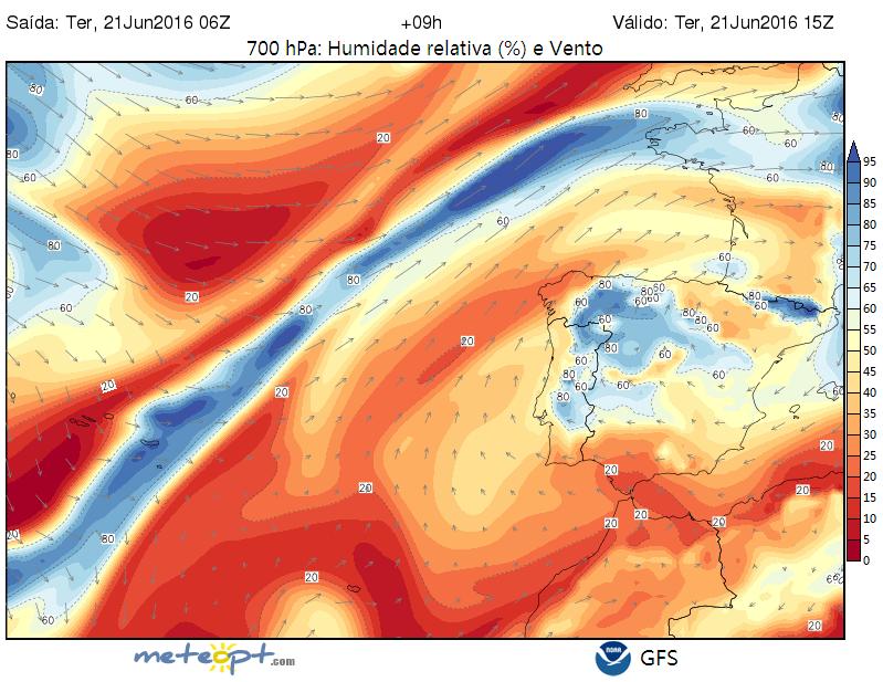
 Nem quero acreditar... para este fim de semana? Mas ainda se mantém essa previsão?