Previsões segundo os modelos (até 2 semanas) - Junho 2025
- Thread starter "Charneca" Mundial
- Data de início
-
O novo portal está no ar! Novos meteogramas, cartas, e mais. Mais informações neste tópico
Seguimento Meteorológico: Litoral Norte | Interior Norte e Centro | Litoral Centro | Sul | Açores e Madeira | Livre
Previsões: Curto e médio prazo: até 2 semanas | Longo prazo: mensal e sazonal (Regras e links úteis nos 1ºs posts)
Facebook | Avisos IPMA/Alertas ANEPC
You are using an out of date browser. It may not display this or other websites correctly.
You should upgrade or use an alternative browser.
You should upgrade or use an alternative browser.

StormRic
Furacão
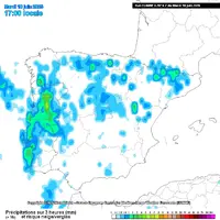
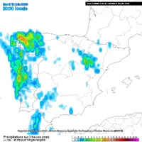
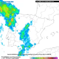
Modelos profundamente em desacordo sobre os acumulados de precipitação para hoje e amanhã:
ECMWF vs UKMO (ambos 18z de ontem)


ECMWF tinha estes acumulados tri-horários:


E com a saída 00Z de hoje a divergência ainda é maior, com o UKMO praticamente a cancelar quase tudo, mal chegando a acumulados de 5mm.

Outros modelos, também saída 00z de hoje, acumulados nas 24 horas: não tão radicais como o UKMO no corte em relação ao ECMWF 18z, atingindo os 10mm.


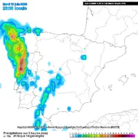
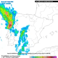
Alargando o intervalo às 48 horas (dias 10 e 11), para englobar todo o período de aviso:


Voltando a comparar com a saída 18z do ECMWF (dias 10 e 11)

E o WRF 18z também (dias 10 e 11) com um contraste acentuado quanto ao Litoral Norte e Interior Norte e Centro.

ECMWF vs UKMO (ambos 18z de ontem)
ECMWF tinha estes acumulados tri-horários:
E com a saída 00Z de hoje a divergência ainda é maior, com o UKMO praticamente a cancelar quase tudo, mal chegando a acumulados de 5mm.
Outros modelos, também saída 00z de hoje, acumulados nas 24 horas: não tão radicais como o UKMO no corte em relação ao ECMWF 18z, atingindo os 10mm.
Alargando o intervalo às 48 horas (dias 10 e 11), para englobar todo o período de aviso:
Voltando a comparar com a saída 18z do ECMWF (dias 10 e 11)
E o WRF 18z também (dias 10 e 11) com um contraste acentuado quanto ao Litoral Norte e Interior Norte e Centro.
guimeixen
Cumulonimbus
Estofex para hoje:

A level 2 was issued across N half of Portugal and NW Spain mainly for heavy rainfall, large to very large hail and severe wind gusts.
... Portugal to NW Spain ...
A pronounced low over the Atlantic will slowly approach Iberia with short-wave swinging from south to north during the forecast period. Strong mid to upper tropospheric flow is located on the forward flank of the low, yielding strongly sheared environment. Towards the evening, a cold front of the low will progress eastwards and will begin to affect the area.
With strong daytime heating over the interior Spain, an elevated mixed layer with steep lapse rates will be advected towards Portugal and NW Spain. Here, a convergence zone will set up between very dry air from east and westerly moist flow. Moisture pooling in the zone will result in a band of 1000 - 2500 J/kg of MLCAPE, overlapping with 15 - 25 m/s of 0-6 km bulk shear. Storms will be primarily initiated by the advancing cold front. With mean wind pointing towards the cooler air west side of the front, much of the storm activity will be elevated and storms will encounter decreasing CAPE values. Nevertheless, there will be threat of large to very large hail and heavy rainfall. Very large hail is more likely especially in the beginning of the period and with right-moving supercells that manage to stay in the higher CAPE area. Severe wind gust threat will be pronounced especially in the east of the highlighted area and in the early stage of the situation, when surface-based convection will be more likely. Heavy rainfall threat may continue well overnight with multiple possible waves of storms as the front only slowly passes to the east.
Tradução:
Foi emitido um nível 2 para a metade norte de Portugal e o noroeste de Espanha, principalmente devido a precipitação forte, granizo grande a muito grande e rajadas de vento fortes.
... Portugal a NW de Espanha ...
Uma baixa pronunciada sobre o Atlântico irá aproximar-se lentamente da Península Ibérica com ondas curtas a oscilar de sul para norte durante o período de previsão. Forte fluxo troposférico médio a superior está localizado no flanco dianteiro da baixa, produzindo um ambiente fortemente cisalhado. Ao fim da tarde, uma frente fria da baixa irá progredir para leste e começará a afetar a área.
Com um forte aquecimento diurno sobre o interior de Espanha, uma camada mista elevada com taxas de lapsos acentuados será projectada em direção a Portugal e ao Noroeste de Espanha. Aqui, uma zona de convergência irá estabelecer-se entre o ar muito seco de leste e o fluxo húmido de oeste. A acumulação de humidade na zona resultará numa banda de 1000 - 2500 J/kg de MLCAPE, que se sobrepõe a 15 - 25 m/s de cisalhamento de 0-6 km. As tempestades serão iniciadas principalmente pelo avanço da frente fria. Com o vento médio a apontar para o ar mais frio do lado oeste da frente, grande parte da atividade das tempestades será elevada e as tempestades encontrarão valores CAPE decrescentes. No entanto, haverá ameaça de granizo grande a muito grande e precipitação intensa. O granizo muito grande é mais provável, especialmente no início do período e com supercélulas em movimento para a direita que conseguem permanecer na área de CAPE mais elevado. A ameaça de rajadas de vento fortes será pronunciada especialmente a leste da área destacada e na fase inicial da situação, quando a convecção à superfície será mais provável. A ameaça de precipitação forte pode continuar durante a noite com várias ondas possíveis de tempestades, uma vez que a frente passa lentamente para leste.
guimeixen
Cumulonimbus
O modelo HARMONIE-AROME da Aemet já chegou a colocar trovoada aqui pelo litoral norte, agora coloca mais tudo no mar.
Veremos o que acontecerá.


Veremos o que acontecerá.
Última edição:
StormRic
Furacão
grande parte da atividade das tempestades será elevada e as tempestades encontrarão valores CAPE decrescentes. No entanto, haverá ameaça de granizo grande a muito grande e precipitação intensa. O granizo muito grande é mais provável, especialmente no início do período e com supercélulas em movimento para a direita que conseguem permanecer na área de CAPE mais elevado.
O ECMWF 06z estava prometedor, mas uma parte da promessa já não foi cumprida. Aguardemos...
A hora legal no continente é menos 1h do que a afixada nestas imagens.
Anexos
Fiasco total de todos os modelos. Ficou praticamente tudo no mar.
È preciso mais cuidado, nas previsões, mais um evento que prova isso.Fiasco total de todos os modelos. Ficou praticamente tudo no mar.
Os modelos valem o que valem.
Northern Lights
Nimbostratus
É um tipo de evento de difícil previsão, por isso tal situação não me espanta.
Direi que é sim preciso um pouco de mais critério quando se dá a informação ao público.
Nas redes sociais parecia certo o dilúvio no norte e centro, quando na realidade só com o Nowcasting se iria saber a certeza.
Prevenir, sim. Mas com cuidado na forma com que se passa a informação.
Neste caso, ainda bem que as "previsões" não se concretizaram.
joralentejano
Furacão
Praticamente todos os modelos indicavam potencial para uma situação severa nas regiões Norte e Centro, sendo que o estofex até colocou risco de nível 2. No entanto, houve um modelo que nunca mostrou um cenário tão mau: o AROME da AEMET. Também falha, como é evidente, mas costuma ficar bastante próximo da realidade em muitas destas situações de instabilidade.É um tipo de evento de difícil previsão, por isso tal situação não me espanta.
Direi que é sim preciso um pouco de mais critério quando se dá a informação ao público.
Nas redes sociais parecia certo o dilúvio no norte e centro, quando na realidade só com o Nowcasting se iria saber a certeza.
Prevenir, sim. Mas com cuidado na forma com que se passa a informação.
Neste caso, ainda bem que as "previsões" não se concretizaram.
As células no mar eram muito intensas, se tivessem atingido terra teria sido grave. Mesmo assim, das poucas células que atingiram terra resultou queda de granizo com dimensões significativas, portanto imagine-se caso a maioria não tivesse passado ao largo.
Qualquer pessoa ligada à meteorologia sabe que os modelos podem falhar, ainda mais nestas circunstâncias, pois basta o posicionamento da depressão estar uns km's mais a leste ou oeste para fazer uma grande diferença e passar tudo ou lado ou atingir locais que não se esperava. O nowcasting é o mais importante, mas também convém alertar. No entanto, lançar o drama e o horror para ter likes é que não é conveniente como por vezes se vê por aí.
Última edição:
Praticamente todos os modelos indicavam potencial para uma situação severa nas regiões Norte e Centro, sendo que o estofex até colocou risco de nível 2. No entanto, houve um modelo que nunca mostrou um cenário tão mau: o AROME da AEMET. Também falha, como é evidente, mas costuma ficar bastante próximo da realidade em muitas destas situações de instabilidade.
As células no mar eram muito intensas, se tivessem atingido terra teria sido grave. Mesmo assim, das poucas células que atingiram terra resultou queda de granizo com dimensões significativas, portanto imagine-se caso a maioria não tivesse passado ao largo.
Qualquer pessoa ligada à meteorologia sabe que os modelos podem falhar, ainda mais nestas circunstâncias, pois basta o posicionamento da depressão estar uns km's mais a leste ou oeste para fazer uma grande diferença e passar tudo ou lado ou atingir locais que não se esperava. O nowcasting é o mais importante, mas também convém alertar. No entanto, lançar o drama e o horror para ter likes é que não é conveniente como por vezes se vê por aí.
Sem dúvida. Tivemos ecos roxos no litoral norte, mas apenas uma faixa costeira "ínfima" foi afectada por uma parte desses ecos. Ontem à noite estava junto à praia de Leça e caíu granizo de 1.5 cm. Estive com pessoas que estavam na zona do MarShopping (< de 2km da costa) à mesma hora e lá praticamente nem pingou.
Tivessemos aqueles ecos 15 ou 20 min nas zonas mais densamente povoadas e iria certamente haver problemas.
'Mini-furacão' iminente nos Açores 

Na realidade, o ciclone não terá muita expressão em altitude.


StormRic
Furacão
Como assim, só esse? Desde antes de 24 horas que pus aqui previsões do UKMO e outros que nada tinham que pudesse representar sequer razão para Aviso Amarelo de precipitação. As cartas de previsão ainda podem ser vistas em mensagens anteriores.houve um modelo que nunca mostrou um cenário tão mau: o AROME da AEMET.
Saída 18z de dia 9 do UKMO
Onde é que nesta previsão há sequer uma mínima razão para Aviso Amarelo de precipitação?
Última edição:
Snifa
Furacão
IPMA fala em provável onda de calor na maior parte das estações a partir do dia 15/06:

 www.ipma.pt
Instituto Português do Mar e da Atmosfera
Última edição:


tucha
Nimbostratus
Outra...e ainda nem chegámos ao Verão...IPMA fala em provável onda de calor na maior parte das estações a partir do dia 15/06:
Ver anexo 23251
Instituto Português do Mar e da Atmosfera
Previsão de Segunda a Quinta, altissimas para Lisboa...
4 dias seguidos a mais de 35 graus, a se concretizar vai ser muito mau...
Meninodasnuvens
Nimbostratus
Meteorologicamente já é verão desde dia 1.Outra...e ainda nem chegámos ao Verão...
Previsão de Segunda a Quinta, altissimas para Lisboa...
4 dias seguidos a mais de 35 graus, a se concretizar vai ser muito mau...
Partilhar: