Seguimento Litoral Centro - Outubro 2009
- Thread starter Gilmet
- Data de início
-
O novo portal está no ar! Novos meteogramas, cartas, e mais. Mais informações neste tópico
Seguimento Meteorológico: Litoral Norte | Interior Norte e Centro | Litoral Centro | Sul | Açores e Madeira | Livre
Previsões: Curto e médio prazo: até 2 semanas | Longo prazo: mensal e sazonal (Regras e links úteis nos 1ºs posts)
Facebook | Avisos IPMA/Alertas ANEPC
You are using an out of date browser. It may not display this or other websites correctly.
You should upgrade or use an alternative browser.
You should upgrade or use an alternative browser.
JoãoPT
Nimbostratus
Por aqui 23ºC, céu muito nublado, pinga de vez em quando e o vento já começa a aumentar de intensidade.
JoãoPT
Nimbostratus
Começa a chover de forma fraca.
O Lightning neste momento encontra-se com 20.8ºC, humidade a 92% e vento a 4.6km/h com uma rajada máxima de 19.8km/h.
O Lightning neste momento encontra-se com 20.8ºC, humidade a 92% e vento a 4.6km/h com uma rajada máxima de 19.8km/h.
MSantos
Moderação
Aqui por Linda-a-Velha o céu esta encoberto mas nada de chuva por enquanto")
Veremos o que nos reserva a tarde
Veremos o que nos reserva a tarde
HotSpot
Cumulonimbus
thunderboy
Cumulonimbus
Céu completamente encoberto e 26.8ºC.
Vento quase nulo.
A ver o que a tarde nos reserva...
Fotos:
SE

NE

NO

Vento quase nulo.
A ver o que a tarde nos reserva...
Fotos:
SE

NE

NO

MSantos
Moderação
JoãoPT
Nimbostratus
Por aqui o céu está meramente encoberto, sem lenticulares nem nada do género, começa agora a chover de novo fraco.
23,5ºC e vento fraco a moderado.
de novo fraco.23,5ºC e vento fraco a moderado.
AndréFrade
Cumulonimbus

O Estofex também dá o seu sinal 
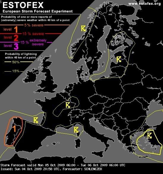
An upper cut-off low near the Azores leads to advection of a tropical airmass towards Iberia and extreme W Morocco. Heavy rainfall is expected in extreme W Iberia where some low-end instability is forecast in a region with high effective PWAT values.
DISCUSSION
..extreme W Iberia...
Although CAPE should not exceed a few hundred J/kg, strong moisture advection due to intense SWerly winds at lower levels may favor a large area of precipitation with embedded multicells. Storms may affect the same area for several hours which leads to excessive precipitation and local flooding.


 :rolleyes:")