Sismos internacionais 2020

luismeteo3

Furacão
Registo
14 Dez 2015
Mensagens
17,112
Local
Fatima (320m)
5.8-magnitude quake strikes Puerto Rico, damage reported

https://apnews.com/3281a57a610c3fabbc65817e59f79633

MagnitudeMw 5.7RegionPUERTO RICO REGION
Date time2020-01-06 10:32:20.0 UTC
Location17.87 N ; 66.83 W
Depth2 km
Distances101 km SW of San Juan, Puerto Rico / pop: 419,000 / local time: 06:32:20.0 2020-01-06
68 km SE of Aguada, Puerto Rico / pop: 4,100 / local time: 06:32:20.0 2020-01-06
14 km SE of Maria Antonia, Puerto Rico / pop: 1,500 / local time: 06:32:20.0 2020-01-06
817247.regional.jpg
 
Última edição:
  • Gosto
Reactions: Wessel1985


Younger Dryas

Nimbostratus
Registo
8 Nov 2019
Mensagens
957
Local
...
Tsunami alert for Puerto Rico after second earthquake in two days hits US territory
https://www.independent.co.uk/news/...ower-blackout-us-virgin-islands-a9273466.html


Not worried about the overwhelming amount of earthquakes in Puerto Rico?
You should be!
A mere 4.5 magnitude earthquake could cause an avalanche in the Puerto Rico Trench causing a tsunami on East Coast.

All times Eastern Time Zone
6:18am 6.0 downgraded to 5.6
3:50am 5.2
3:34am 5.6 downgraded to 5.5
3:24am 6.7 downgraded to 6.3
Past 8 hours, 18 Magnitude 4 - 4.9

Total of 22, Magnitude 4 or greater, earthquakes in 8 hours just in Puerto Rico.
WATCH THAT TRENCH. BE ALERT!

Apesar do artigo ser de 2012 continua actual o risco de tsunami por movimentos de vertente submarino
US East Coast Faces Variety of Tsunami Threats
https://www.livescience.com/24813-east-coast-tsunamis.html
 
Última edição:

luismeteo3

Furacão
Registo
14 Dez 2015
Mensagens
17,112
Local
Fatima (320m)
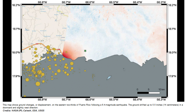
Days after a 6.4-magnitude earthquake rocked Puerto Rico, followed by hundreds of aftershocks, the full extent of damage is only beginning to be realized.

NASA scientists are using satellite data to help federal and local agencies identify areas with potential damage. Earthquakes cause permanent changes to the ground surface. By comparing interferometric synthetic aperture radar (InSAR) data acquired on Jan. 9, 2020, with data acquired on Dec. 28, 2019, from the Copernicus Sentinel-1A
satellite, the scientists were able to map where, how much and in what direction those changes occurred.

Managed by the European Space Agency (ESA), the Copernicus Sentinel-1A satellite was able to see the eastern two-thirds of the island during the Jan. 9 flyover. On the map, red indicates areas where the ground was changed, or displaced, with darker shades corresponding to more significant displacement. The scientists found that the greatest
displacement from the flyover area occurred west of the city of Ponce (identified by the green star), not far from the quake's offshore epicenter. They recorded up to 5.5 inches (14 centimeters) of ground change there. The ground appeared to shift downward and slightly to the west.