Formou-se a Tempestade Tropical MARCO no Golfo do México.

-------------
Informação
Para o seguimento da época de furacões no Atlântico consulte também o tópico «Links Úteis e Climatologia da Época de Furacões no Atlântico» com dezenas de link's para imagens de satélite, modelos, observações, radares e serviços nacionais de meteorologia.
-------------
Aviso MeteoPT
As análises, previsões ou alertas neste forum são apenas a opinião dos utilizadores que as proferem e são da sua inteira responsabilidade.
Não são previsões ou alertas de entidades oficiais, salvo indicação em contrário, não devendo portanto ser usadas como tal.
Para previsões e alertas oficiais, consulte sempre os produtos do NHC (National Hurricane Center) ou outras entidades com essa função.
..BAY OF CAMPECHE DEPRESSION STRENGTHENS INTO A TROPICAL STORM...
AT 4 PM CDT...2100 UTC...THE GOVERNMENT OF MEXICO HAS ISSUED A
HURRICANE WATCH FOR THE GULF COAST OF MEXICO FROM CABO ROJO
SOUTHWARD TO VERACRUZ. A HURRICANE WATCH MEANS THAT HURRICANE
CONDITIONS ARE POSSIBLE WITHIN THE WATCH AREA...IN THIS CASE WITHIN
THE NEXT 24 HOURS.
AT 4 PM CDT...2100 UTC...THE TROPICAL STORM WARNING HAS BEEN
EXTENDED NORTHWARD TO CABO ROJO. A TROPICAL STORM WARNING IS NOW
IN EFFECT FOR THE GULF COAST OF MEXICO FROM CABO ROJO SOUTHWARD TO
PUNTA EL LAGARTO. A TROPICAL STORM WARNING MEANS THAT TROPICAL
STORM CONDITIONS ARE EXPECTED WITHIN THE WARNING AREA WITHIN THE
NEXT 24 HOURS.
FOR STORM INFORMATION SPECIFIC TO YOUR AREA...INCLUDING POSSIBLE
INLAND WATCHES AND WARNINGS...PLEASE MONITOR PRODUCTS ISSUED
BY YOUR LOCAL WEATHER OFFICE.
REPORTS FROM AN AIR FORCE HURRICANE HUNTER AIRCRAFT INDICATE THAT
TROPICAL DEPRESSION THIRTEEN HAS STRENGTHENED...AND IS NOW A
TROPICAL STORM.
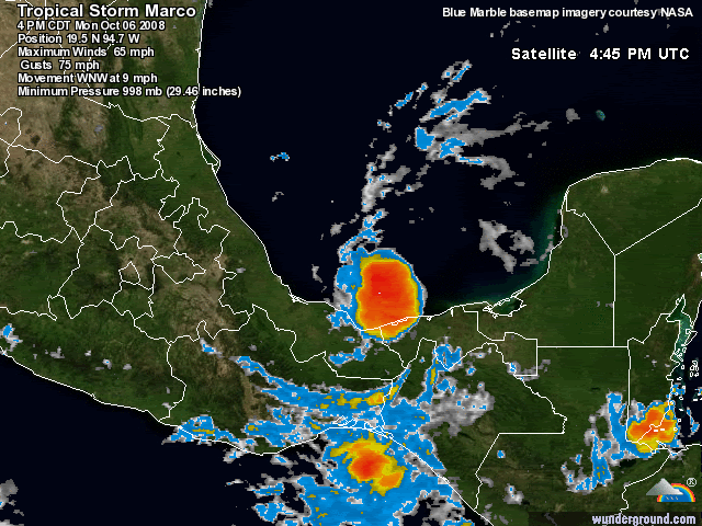
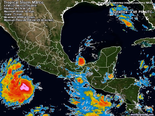
AT 400 PM CDT...2100Z...THE CENTER OF TROPICAL STORM MARCO WAS
LOCATED NEAR LATITUDE 19.5 NORTH...LONGITUDE 94.7 WEST OR ABOUT 100
MILES...160 KM...EAST-NORTHEAST OF VERACRUZ MEXICO.
MARCO IS MOVING TOWARD THE WEST-NORTHWEST NEAR 9 MPH...15 KM/HR...
AND THIS GENERAL MOTION IS EXPECTED TO CONTINUE FOR THE NEXT DAY OR
SO. ON THE FORECAST TRACK...THE CENTER WILL BE NEAR THE COAST OF
MEXICO WITHIN THE WARNING AREA LATE TONIGHT OR EARLY TUESDAY.
MAXIMUM SUSTAINED WINDS HAVE INCREASED TO NEAR 65 MPH...100
KM/HR...WITH HIGHER GUSTS. SOME STRENGTHENING IS FORECAST DURING
THE NEXT 24 HOURS...AND MARCO COULD APPROACH HURRICANE STRENGTH AS
IT NEARS THE COAST.
MARCO IS A SMALL TROPICAL CYCLONE. TROPICAL STORM FORCE WINDS
EXTEND OUTWARD UP TO 30 MILES...45 KM FROM THE CENTER.
THE MINIMUM CENTRAL PRESSURE REPORTED BY THE HURRICANE HUNTER
AIRCRAFT WAS 998 MB...29.47 INCHES.
MARCO IS EXPECTED TO PRODUCE TOTAL RAINFALL AMOUNTS OF 2 TO 4 INCHES
WITH MAXIMUM AMOUNTS OF 6 INCHES POSSIBLE ACROSS THE SOUTHERN
MEXICAN STATES OF VERACRUZ...NORTHERN OAXACA...AND TABASCO.
-------------
Informação
Para o seguimento da época de furacões no Atlântico consulte também o tópico «Links Úteis e Climatologia da Época de Furacões no Atlântico» com dezenas de link's para imagens de satélite, modelos, observações, radares e serviços nacionais de meteorologia.
-------------
Aviso MeteoPT
As análises, previsões ou alertas neste forum são apenas a opinião dos utilizadores que as proferem e são da sua inteira responsabilidade.
Não são previsões ou alertas de entidades oficiais, salvo indicação em contrário, não devendo portanto ser usadas como tal.
Para previsões e alertas oficiais, consulte sempre os produtos do NHC (National Hurricane Center) ou outras entidades com essa função.