Tempestade Tropical PATTY (Atlântico 2024 #AL17)

  • Thread starter Thread starter Afgdr
  • Data de início Data de início
Patty continua a enfraquecer - ventos máximos sustentados de 45 mph ≈ 72 km/h e rajadas até 52 mph ≈ 84 km/h. A pressão mínima central subiu para os 992 hPa.


MUKUqhX.gif


UHGt9l0.gif


Gráfico NHC

qN9YYmY.png
 
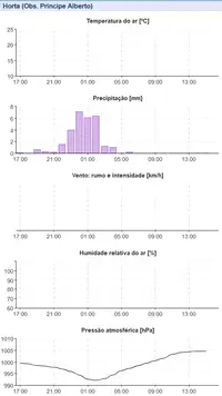
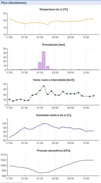
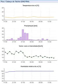
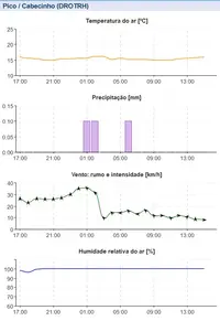
Assinatura de Patty no Faial, Pico, São Jorge e Graciosa.
 

Anexos

  • Graf-HortaObserv_20241103-15.webp
    Graf-HortaObserv_20241103-15.webp
    24.7 KB · Visto: 12
  • Graf-PicoAerodromo_20241103-15.webp
    Graf-PicoAerodromo_20241103-15.webp
    31.1 KB · Visto: 11
  • Graf-CabeçoTeicho_20241103-15.webp
    Graf-CabeçoTeicho_20241103-15.webp
    24.1 KB · Visto: 9
  • Graf-Cabecinho_20241103-15.webp
    Graf-Cabecinho_20241103-15.webp
    23.3 KB · Visto: 9
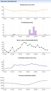
  • Graf-GraciosaAero_20241103-15.webp
    Graf-GraciosaAero_20241103-15.webp
    31.2 KB · Visto: 9
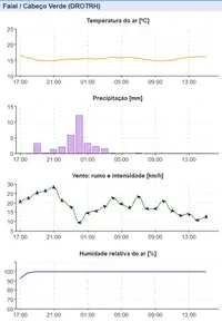
  • Graf-CabeçoVerde_20241103-15.webp
    Graf-CabeçoVerde_20241103-15.webp
    24.6 KB · Visto: 11
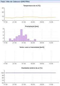
  • Graf-AltoCabouco_20241103-15.webp
    Graf-AltoCabouco_20241103-15.webp
    20.3 KB · Visto: 12
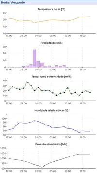
  • Graf-HortaAeroporto_20241103-15.webp
    Graf-HortaAeroporto_20241103-15.webp
    30.6 KB · Visto: 12
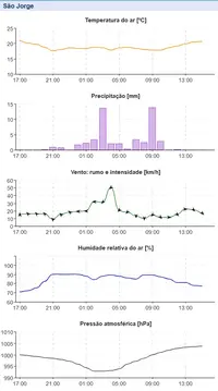
  • Graf-SãoJorge_20241103-15.webp
    Graf-SãoJorge_20241103-15.webp
    30.6 KB · Visto: 9
Terceira, São Miguel
 

Anexos

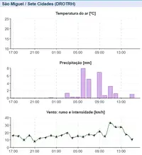
  • Graf-SeteCidades_20241103-15.webp
    Graf-SeteCidades_20241103-15.webp
    18.4 KB · Visto: 10
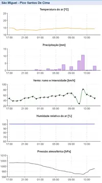
  • Graf-SantosCima_20241103-15.webp
    Graf-SantosCima_20241103-15.webp
    28.6 KB · Visto: 10
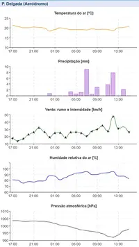
  • Graf-PDelgadaAero_20241103-15.webp
    Graf-PDelgadaAero_20241103-15.webp
    31.7 KB · Visto: 9
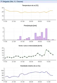
  • Graf-PDelgadaObserv_20241103-15.webp
    Graf-PDelgadaObserv_20241103-15.webp
    26.1 KB · Visto: 10
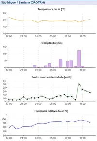
  • Graf-Santana_20241103-15.webp
    Graf-Santana_20241103-15.webp
    25.9 KB · Visto: 9
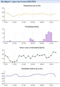
  • Graf-Furnas_20241103-15.webp
    Graf-Furnas_20241103-15.webp
    26.2 KB · Visto: 8
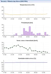
  • Graf-RibeiraNove_20241103-15.webp
    Graf-RibeiraNove_20241103-15.webp
    24.8 KB · Visto: 12
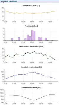
  • Graf-AngraHeroísmo_20241103-15.webp
    Graf-AngraHeroísmo_20241103-15.webp
    30.7 KB · Visto: 11
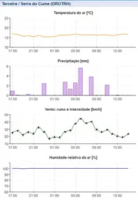
  • Graf-SerraCume_20241103-15.webp
    Graf-SerraCume_20241103-15.webp
    23.5 KB · Visto: 10


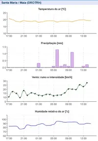
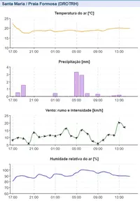
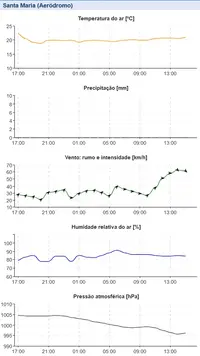
Excetuando-se a estação do Pico Santos de Cima, que está localizada numa zona alta, a estação do Aeroporto de Santa Maria (LPAZ), que fica a 96 m de altitude, foi a única que registou vento de tempestade tropical (vento médio), no limite inferior (≥39 mph ≈ 63 km/h).
 
Mesmo no fim do seu percurso sub-tropical, Patty gera agora convecção forte.

Ia postar isso agora mesmo:

oBxMARq.gif


50QIcks.gif


Na atualização das 21h00 UTC, Patty mantinha a sua intensidade.


SUMMARY OF 900 PM GMT...2100 UTC...INFORMATION
----------------------------------------------
LOCATION...37.3N 22.3W
ABOUT 280 MI...450 KM ESE OF LAJES AIR BASE IN THE AZORES
MAXIMUM SUSTAINED WINDS...45 MPH...75 KM/H
PRESENT MOVEMENT...E OR 95 DEGREES AT 17 MPH...28 KM/H
MINIMUM CENTRAL PRESSURE...990 MB...29.24 INCHES


6UqlFsl.png
 
Até agora, Patty estava categorizada como tempestade subtropical nestes sites.
Sempre foi categorizada como sub-tropical pelo NHC, pode ser uma simplificação 'abusiva' por parte desses sites.

"
Subtropical Storm Patty Discussion Number 7
NWS National Hurricane Center Miami FL AL172024
900 PM GMT Sun Nov 03 2024

After being devoid of deep convection for much of the day,
thunderstorms have reformed near the center of Patty. Therefore,
Patty will hold its subtropical storm designation for now.
The
initial intensity is held at 40 kt in deference to the earlier
scatterometer data. However, strong vertical wind shear, dry
mid-latitude air, and cool sea surface temperatures should weaken
Patty during the next couple of days. No changes have been made to
the latest NHC intensity forecast.

The storm is moving eastward at 15 kt and is forecast to move
eastward to east-northeastward for the next couple of days. Patty
is still expected to open into a trough near or over western Europe,
and only minor adjustments have been made to the official track
forecast.


FORECAST POSITIONS AND MAX WINDS

INIT 03/2100Z 37.3N 22.3W 40 KT 45 MPH
12H 04/0600Z 37.7N 19.0W 35 KT 40 MPH...POST-TROPICAL
24H 04/1800Z 38.9N 14.8W 30 KT 35 MPH...POST-TROP/REMNT LOW
36H 05/0600Z 40.2N 11.5W 30 KT 35 MPH...POST-TROP/REMNT LOW
48H 05/1800Z 41.2N 8.7W 25 KT 30 MPH...POST-TROP/REMNT LOW
60H 06/0600Z...DISSIPATED

$$
Forecaster Bucci"
 
Confirma-se. O NHC acaba de categorizar Patty como tempestade tropical.

BULLETIN
Tropical Storm Patty Advisory Number 8
NWS National Hurricane Center Miami FL AL172024
300 AM GMT Mon Nov 04 2024

...PATTY TRANSITIONS TO A TROPICAL STORM...
...EXPECTED TO BECOME POST-TROPICAL IN A DAY OR SO...


SUMMARY OF 300 AM GMT...0300 UTC...INFORMATION
----------------------------------------------
LOCATION...37.7N 20.0W
ABOUT 380 MI...615 KM E OF THE AZORES
MAXIMUM SUSTAINED WINDS...45 MPH...75 KM/H
PRESENT MOVEMENT...E OR 85 DEGREES AT 20 MPH...31 KM/H
MINIMUM CENTRAL PRESSURE...993 MB...29.33 INCHES
 
Ocorreu transição tropical, mas manteve a sua intensidade.


Tropical Storm Patty Discussion Number 8
NWS National Hurricane Center Miami FL AL172024
300 AM GMT Mon Nov 04 2024

Patty has continued producing deep convection since the time of the
previous advisory, although the convective structure has recently
degraded slightly on the latest infrared images. The infrared
satellite images and an 03/2138 UTC ASCAT pass depict a more compact
cyclone with a confined radius of maximum winds than earlier in the
system's life. Patty is also no longer co-located with the
upper-level low that was earlier responsible for its hybrid
characteristics. Based on these observations, Patty has made the

transition into a tropical storm. The earlier ASCAT pass showed
tropical storm force winds as high as 39 kt in the southern
semicircle. The initial intensity is therefore held at 40 kt.


tseHu8l.png


LVOKP1s.png


Deverá ser uma TT de curta duração, perdendo as suas características tropicais à medida que avança para águas tendencialmente mais frias, em direção à Península Ibérica.

FORECAST POSITIONS AND MAX WINDS

INIT 04/0300Z 37.7N 20.0W 40 KT 45 MPH
12H 04/1200Z 38.4N 16.7W 40 KT 45 MPH
24H 05/0000Z 39.8N 12.8W 35 KT 40 MPH...POST-TROPICAL
36H 05/1200Z 41.0N 10.0W 30 KT 35 MPH...POST-TROP/REMNT LOW
48H 06/0000Z...DISSIPATED


ix61f0j.png