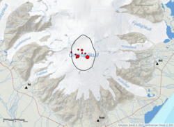
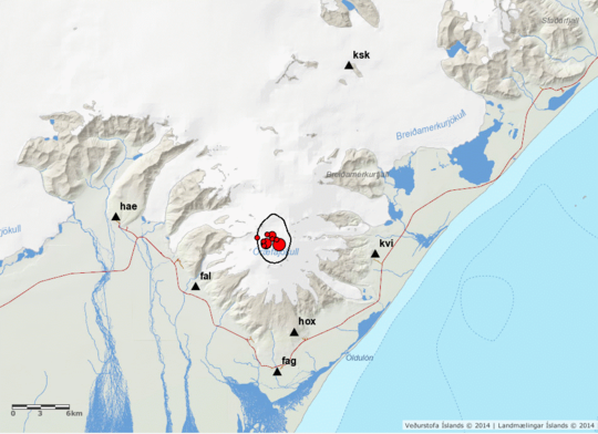
Öræfajökull. Earthquake 3.6 in the caldera of Öræfajökull
9.2.2018
On the 9th February 2018 at 05:07, an earthquake of magnitude 3.6 occurred within the caldera of Öræfajökull volcano. Around 10 aftershocks have been recorded. The earthquake was felt by few people in the area, however most people slept through it.
This earthquake is the largest recorded in Öræfajökull (instrumentation in the area started in 1976). The earthquake occurred inside the caldera just southeast of the ice-cauldron that formed in November last year. The depth seems to be confined in the first few kms of the crust. Öræfajökull has been showing signs of unrest for over a year. Two other earthquakes larger than M3 have been recorded since last fall (M3.5 on the 3rd October 2017 and M3.1 on the 18th January 2018).
No significant changes have been observed for the past weeks with other monitoring data, including deformation, hydrological and geochemical data available to the Icelandic Meteorological Office. An overflight, to measure glacial surface will be done as soon as the weather condition allow. This is important as it can reflect changes of the underlying geothermal system. In addition, satellite images will be acquired in the next days to identify possible changes of the ice-surface. No significant changes have been seen in the satellite images this year (last image required end of January).
The Aviation Color Code for Öræfajökull is kept on a yellow level. IMO keeps monitoring the volcano 24/7 and any detected relevant changes will be communicated promptly through the usual channels.
Hydrothermal activity creates dangerous ice cave in Hofsjökull volcano
Posted on February 14, 2018 by Jón Frímann
Hydrothermal activity has formed a ice cave in Hofsjökull glacier (volcano details here). According to an announcement by Icelandic Met Office this ice cave is dangerous due to sulphur (SO2) pollution and that it goes above 60ppm. That can result in loss of breathing, loss of vision and damage to eyes and lungs. People should only enter this ice cave with gas monitoring hardware on them. One seven year old girl passed out due to sulphur poising some weeks ago in a trip to this newly formed ice cave. There is also a high risk of collapse from the roof of the ice cave as ice appears to be loose above it and can collapse down without warning at any time.
There is also a risk of hydrothermal activity increasing and that is going to result in more sulphur (SO2) gas in the cave and other dangerous gases coming up. This appears to the same location that had increased activity 15 years ago that also formed an ice cave. The reason for this increase in hydrothermal activity is unclear since no earthquake activity has been recorded in Hofsjökull volcano for the past 10 years. This means earthquake activity above background levels, one or three earthquakes are recorded each year in random part of the caldera or parts of Hofsjökull volcano outside of the caldera area. Höfsjökull volcano is on its own rifting zone (information here, related paper here) (marked as SRZ on some documents) along with Kerlingarfjöll volcano (it is now under GVP as Hreppar. I don’t know why that is). http://www.jonfr.com/volcano/?p=7340 http://www.ruv.is/frett/vedurstofa-varar-vid-ishelli-i-hofsjokli
Increase in the earthquake activity in TFZ (Tjörnes Fracture Zone)
Posted on February 15, 2018 by Jón Frímann
Information in this article might get outdated quickly due to fast moving nature of the current earthquake swarm in TFZ.
The earthquake swarm that started on 28-January-2018 continues (article here). A strong earthquake swarm started east of Grímsey island almost 18 hours ago (it started around 18:00 UTC on 14-February-2018). Over 500 earthquakes have been recorded so far, most of them are between magnitude 0,0 – 2,0. In the last 48 hours three earthquakes with magnitude above 3,0 have been recorded.
At the moment there is nothing suggesting that this earthquake swarm is connected to any magma movement. It seems to be just connected to tectonic movements in this area. This earthquake activity appears to be taking place in a volcano but that volcano doesn’t have any documented historical eruption so it is impossible to know what might happen. Last eruption in this area was in a volcano south of current earthquake activity. That volcano erupted in the years 1867 December – 1868 January, Global Volcanism Profile can be found here. http://www.jonfr.com/volcano/?p=7342
[/quote]
À parte da sismicidade, a representação gráfica está muito boa.
Dá uma imagem muito clara do que se passa debaixo dos nossos pés... seria um bom investimento para o CIVISA monitorizar a atividade sísmica nos Açores