AndréFrade
Cumulonimbus
Temperatura máxima com subida ligeira e índice UV muito alto
Bem, se ontem já por aqui foi um forno, imagino Hoje
 .
.Temperatura máxima com subida ligeira e índice UV muito alto
 .
.
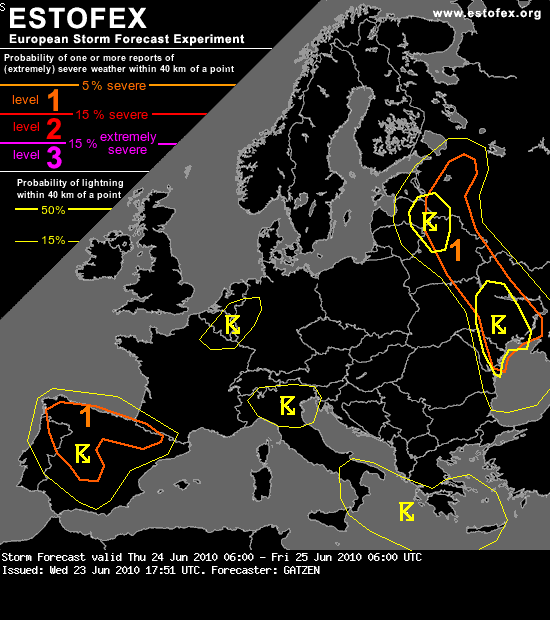
Northern Iberia
Strong diurnal heating will likely lead to CAPE given some low-level moisture and a deeply mixed air mass. Storms may develop especially along a convergence zone over the north-western portions where the sea-breeze and upslope flow will be present. Additional QG forcing may result from a weak mid-level low to the west. Storms may produce large hail given the strong buoyancy. Additionally, some downbursts may occur with a slight chance of severe wind gusts. Storms will likely weaken after sunset.


SYNOPSIS and DISCUSSION
A shallow ridge affects W-Europe beneath gradually lowering geopotential heights. In fact, geopotential heights decrease over most parts of Europe, as various more or less defined troughs/short waves affect the forecast area. For the past few days, BL air mass had some time to recover and some moisture advection took place at mid-levels over W-Europe, so overall thunderstorm coverage increases over many places. Initiation occurs at numerous spots, along mountain ranges, where regionally better BL air mass quality or forcing is present and along weak frontal boundaries.
Shear/CAPE fields remain modest at best, so nothing organized is expected in this forecast package. Estonia/Latvia, NW/N-Italy and Spain will have the best CAPE build-up for isolated stronger updrafts with large hail and strong wind gusts.
After sunset, thunderstorms gradually decrease in coverage and intensity.


Alerta AMARELO - Distritos:
VILA REAL , BRAGANÇA , GUARDA, VISEU, CASTELO BRANCO e PORTALEGRE - Trovoadas frequentes e dispersas
Sou novo nesta ciencia da meteorologia, mas não entendo onde eles veem isso
 .
.Alerta AMARELO - Distritos:
VILA REAL , BRAGANÇA , GUARDA, VISEU, CASTELO BRANCO e PORTALEGRE - Trovoadas frequentes e dispersas
Sou novo nesta ciencia da meteorologia, mas não entendo onde eles veem isso


