Ciclones Tropicais no Mediterrâneo

Vince

Furacão
Registo
23 Jan 2007
Mensagens
10,624
Local
Braga
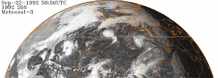
O Jeff Master do Wunderground falou hoje do sistema de Espanha e diz que provavelmente foi um sistema com algumas características hibridas, embora predominantemente não tropical.

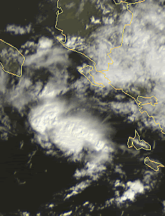
"Medicane" (Medepression?) hits Spain
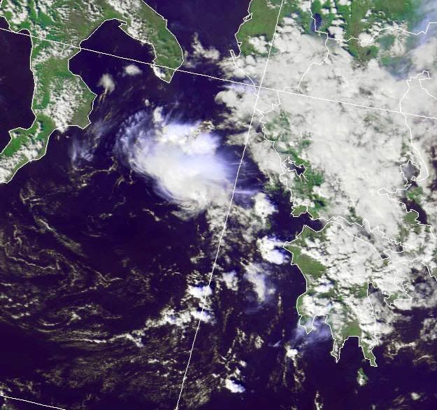
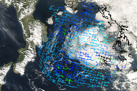
A tropical storm-like system swept over the island of Majorca in the Mediterranean on Wednesday, triggering flooding that killed two people. The storm then made landfall on the Mediterranean coast of Spain yesterday morning near the city of Murcia. The satellite presentation of the storm at landfall (Figure 1) showed well-formed spiral bands and a cloud-free center. Murcia, Spain reported sustained winds of 30 mph, gusting to 45 mph, at 14 GMT Thursday. A personal weather station in Santa Pola recorded sustained winds of 40 mph, gusting to 45 mph, and 0.68 inches of rain during passage of the storm. We have a number of other personal weather stations in the region, but none reported higher winds, or a pressure lower than 1013 mb. Radar from the Spanish Instituto Nacional de Meteorologia (Figure 2) showed some well-organized banding. The UKMET model did not indicate the storm had a warm core, so this was likely not a true tropical depression. Sea surface temperatures were about 23° C (about 1° C warmer than normal) under the storm, which is quite a bit colder than the 26.5° C usually associated with tropical storm formation. The satellite presentation suggests that the storm was probably generating a shallow warm core near the surface, and was getting some of its energy from release of latent heat--the same energy source that powers tropical cyclones. Yesterday's "Medepression" was probably a hybrid tropical/extratropical storm, and was predominantly non-tropical.

Warm-cored hybrid storms have been reported in the Mediterranean Sea before, and there is a large body of scientific literature published on the subject (see below). These storms can become quite severe and cause considerable damage. However, there is no system in place to name these storms, and the National Hurricane Center is not responsible for issuing warnings in the Mediterranean Sea. There are quite a few "Medicanes" in past years that would have earned names as subtropical storms had NHC been responsible for warnings in the Mediterranean Sea. There is concern that global warming may raise sea surface temperatures enough in the Mediterannean later this century to allow full-fledged hurricanes to form and threaten the densely populated cities that dot the coast.

De qualquer forma, o sistema ainda não morreu, e manteve hoje alguma convecção entre o sul de Espanha e Marrocos, e o Tropical RADMSIS do CIRA (Cooperative Institute for Research in the Atmospher) colocou esta manhã um floater sobre ele, ou seja, pelo menos está a despertar a curiosidade cientifica/meteorológica. Mas parece estar agora a dissipar.


Vince

Furacão
Registo
23 Jan 2007
Mensagens
10,624
Local
Braga
Boas!

Já no meu blog eu havia referido algo do género...
Podem verificar:

http://meteorologiapt.blogspot.com/2007/09/furaces-na-pennsula-ibrica.html

Oi, isso que referes nunca aconteceu. Ou explicando melhor, aconteceu mas não naquele local. A imagem resultou dum erro do software de processamento das imagens de satélite.

Se reparares com atenção nesta que te deixo podes ver o sombreado dos EUA com a costa leste completamente deslocada para o meio do Atlântico, deslocando também os 2 furacões da imagem para o Mediterrâneo quando na realidade estavam no Atlântico.

erro.jpg


Por acaso conheço as imagens com o erro bastante bem, porque os dois furacões da imagem afectaram Portugal, mas não o continente. Os furacões da imagem são o Bonnie e o Charley de 1992 e ambos atravessaram o arquipélago dos Açores, o que foi algo de invulgar com 2 ciclones tropicais a afectar quase de seguida o arquipélago. Não provocaram muitos danos, mas pelo menos uma pessoa morreu na ilha de S.Miguel devido ao Bonnie.
 

Vince

Furacão
Registo
23 Jan 2007
Mensagens
10,624
Local
Braga
No Domingo passado andou mais um daqueles sistemas suspeitos próximo de Itália, uma espécie de SCM com circulação.

a-3.jpg


a-2.png


anim.gif
 

Vince

Furacão
Registo
23 Jan 2007
Mensagens
10,624
Local
Braga
Depois de muitos anos de discussão, oficialmente o Mediterrâneo passa a ter alguma vigilância tropical embora sem zona (RSMC) definida pela OMM.
O objectivo é quando ocorrer um sistema, haja pelo menos alguns dos recursos normais que costuma haver para outras regiões, invests, floaters satélite, modelos, estimativas dvorak, etc.
Os Invest's terão a letra M, ou seja, 90-99M


DOXX10 KWBC 261345
DATA MGT MESSAGE 04-11.06

TO AWIPS/NOAAPORT USERS.. FAMILY OF SERVICES/FOS/SUBSCRIBERS...
EMERGENCY MANAGERS WEATHER INFORMATION NETWORK /EMWIN/
NATIONAL WEATHER SERVICE /NWS/ CUSTOMERS... WAFS USERS...
GTS USERS... NWS FAX CHART USERS

FROM RTH WASHINGTON DATA MANAGEMENT

CHANGE NOTICE NO 12700
EFFECTIVE DATE SEPTEMBER 1 2011

[12700] ON THE ABOVE EFFECTIVE DATE THE FOLLOWING HEADER IDS
WILL BE CREATED FOR THE ATLANTIC AND MEDITERRANEAN GLOBAL
SATELLITE BASED SUBJECTIVE TROPICAL CYCLONE POSITION AND
INTENSITY ESTIMATES. AS WELL AS CHANGES TO FOLLOWING AWIPS
IDS FOR THE PACIFIC AND INDIAN OCEAN BULLETINS
 

Vince

Furacão
Registo
23 Jan 2007
Mensagens
10,624
Local
Braga
Já tinha sido referido no seguimento da Europa, parece que se faz história hoje, apesar dos sistemas suspeitos de "tropicalidade" do Mediterrâneo não serem novidade, é a primeira vez em que oficialmente um é classificado como ciclone tropical, o 01M NONAME, não tem é direito a nome pois não existe uma lista de nomes nesta região. Foi inicialmente lançado como Invest 99L mas deveria ter sido com a letra M e não L que é do Atlântico, desconheço a razão. O Invest parece ter sido lançado pelo NRL (Marinha americana)


Mediterranean Sea:

DATE/TIME LAT LON CLASSIFICATION STORM
07/1800 UTC 41.1N 5.3E T2.5/2.5 01M
07/1200 UTC 40.6N 5.9E ST1.5 INVEST


TXMM21 KNES 071819
TCSMED

A. 01M (NONAME)
B. 07/1800Z
C. 41.1N
D. 5.3E
E. THREE/MET-9
F. T2.5/2.5/D1.5/24HRS
G. IR/EIR/SWIR
H. REMARKS...DT=2.5 BASED ON .5 BANDING ON LOG10
SPIRAL. PT=2.5. MET=2.0. FT IS BASED ON DT. DEEP CONVECTION HAS PERSISTED
LONG ENOUGH AROUND THE LOW LEVEL CENTER FOR A TROPICAL CLASSIFICATION.

I. ADDL POSITIONS
NIL
...SCHWARTZ
http://www.ssd.noaa.gov/PS/TROP/DATA/2011/bulletins/med/20111107180001M.html


WOMQ50 LFPW 072004

WARNING ON METAREA 3, METEO-FRANCE
WARNING NR 305 , MONDAY 7 NOVEMBER 2011 AT 2000 UTC
GENERAL SYNOPSIS, MONDAY 7 AT 12 UTC :
LOW 1004 OVER WEST OF SARDAIGNE, MOVING EASTWARD EXPECTED 1006
OVER EAST OF SARDAIGNE BY 08/12.
PROVENCE, WEST OF LIGURE :
CONTINUING TO 09/00 UTC AT LEAST.
EASTERLY 8, AT TIMES 9. SEVERE GUSTS.
CORSE :
FROM 8/03 UTC TO 8/12 UTC.
SOUTH OR SOUTHEAST AT TIMES 8. SEVERE GUSTS.
SARDAIGNE :
CONTINUING TO 8/12 UTC.
SOUTH OR SOUTHWEST LOCALLY 8. SEVERE GUSTS. SEA TEMPORARILY HIGH IN
SOUTH AT FIRST.=


O aspecto durante o dia era de um ciclone subtropical/híbrido, embora a partir do início da tarde tenham explodido umas torres com convecção profunda mesmo no centro, o que fez com que o classificassem como tropical, embora o NHC nunca o fizesse com tão poucas horas, o NHC normalmente entende que isso tem que persistir mais tempo.

2rdc2o0.gif


Nesta altura tem um "eye-like"

99l.jpg
 

Vince

Furacão
Registo
23 Jan 2007
Mensagens
10,624
Local
Braga