Hurricane Lorenzo Discussion Number 40
NWS National Hurricane Center Miami FL AL132019
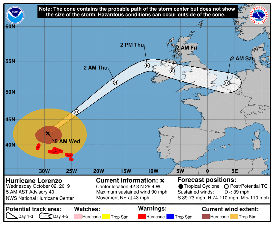
500 AM AST Wed Oct 02 2019
Lorenzo passed near Flores in the Azores a few hours ago where
hurricane-force winds, at least in gusts, were observed. Winds
are now decreasing across those islands. The current intensity
estimate, 75 kt, assumes only slow weakening since late yesterday.
The cloud pattern is becoming increasingly asymmetric in
appearance, suggestive that transition to an extratropical cyclone
is well underway. The global models indicate that Lorenzo will soon
become embedded in a frontal zone, and simulated satellite imagery
from the ECMWF and GFS models show an extratropical-looking cloud
pattern later today. The official forecast calls for a gradual
weakening trend over the next couple of days and is above the
intensity guidance. Although the system is forecast to become
extratropical in 12 hours, it is still likely be a fairly vigorous
cyclone when it reaches Ireland late Thursday. After crossing
England, the low is likely to dissipate over continental Europe.
Lorenzo accelerated significantly late Tuesday, and the motion is
rapidly northeastward, or 040/37 kt. Over the next day or so,
the system should continue to move northeastward ahead of a large
mid-tropospheric trough over the north Atlantic. Then, the cyclone
is forecast to turn eastward and a little south of eastward in the
weaker westerly flow ahead of the trough. The official track
forecast is close to the model consensus, but leans a bit toward
the ECMWF forecast.
Swells generated by Lorenzo have spread across much of the
North Atlantic, and are affecting the east coast of the United
States, Atlantic Canada, the Bahamas, portions of the Greater and
Lesser Antilles, and portions of the coast of Europe. These swells
will produce life-threatening surf and rip currents.