Previsão e Seguimento Ciclones (Índico Norte 2007)

Gerofil

Furacão
Registo
21 Mar 2007
Mensagens
10,059
Local
Estremoz
Re: Ciclones Índico Norte - 2007

Gonu: alguns vídeos do YouTube

[YOUTUBE]http://www.youtube.com/watch?v=uNaFgabC1rg[/YOUTUBE]

[YOUTUBE]http://www.youtube.com/watch?v=x22PU_U0Z_o[/YOUTUBE]

[YOUTUBE]http://www.youtube.com/watch?v=E-lYN3mtdr8[/YOUTUBE]

[YOUTUBE]http://www.youtube.com/watch?v=BJMkcB6g4JU[/YOUTUBE]

[YOUTUBE]http://www.youtube.com/watch?v=DOC__K-cY5M[/YOUTUBE]


Brigantia

Cumulonimbus
Registo
20 Jan 2007
Mensagens
2,204
Local
Norte de Portugal
Ciclone Gonu

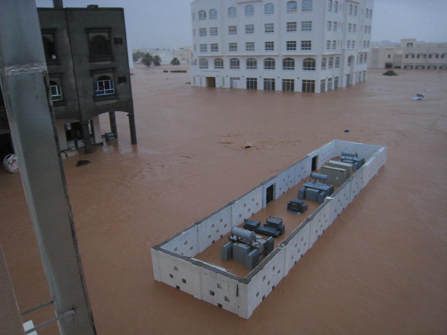
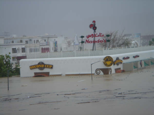
MUSCAT, Oman (AP) -- Cyclone Gonu battered Oman's coast Thursday, flooding highways and tearing down trees and power lines but sparing the region's oil industry.

At least 23 deaths in Oman and Iran were blamed on the cyclone -- a rarity in the Middle East.

But as Gonu headed from Oman to the southeastern Iranian coast, it continued to lose steam, weakening to tropical storm strength, according to the U.S. military's Joint Typhoon Warning Center.

Oil analysts said the weakening storm's effect on the market was minimal.

The center predicted Gonu would make landfall on the southeastern Iranian coast late Thursday.

But it was likely to spare Iran's offshore oil installations that are more than 120 miles to the west, the center and oil officials said.

At least 20 deaths in Oman were blamed on Gonu, including members of police rescue squads, and 24 people were reported missing, said Royal Police spokesman Abdullah al-Harthi.

Rescue teams searched devastated areas in helicopters and boats, he said. (Watch flooded streets, damaged buildings in Muscat )

Across the Gulf of Oman, Iranian state television reported that a resident of the port city of Bandar Abbas was killed in a car accident Wednesday due to low visibility from the storm.

Two provincial government workers bringing emergency supplies to a flooded area also were killed when a river overflowed and flipped their truck in Jask, a town 155 miles southeast of Bandar Abbas, state TV's Web site said.

The storm caused little damage to Oman's relatively small oil fields. But raging seas prevented tankers from sailing from Omani ports, effectively shutting down the country's oil exports, said Nasser bin Khamis al-Jashimi of the Ministry of Oil and Gas.

Authorities also closed all operations at the port of Sohar and evacuated 11,000 workers, port spokesman Dirk Jan De Vink said.

"It looks like Oman has taken its precautions and so far, really, I haven't heard of any disruption to the flow of oil," said Muhammad-Ali Zainy, senior energy analyst at London-based Center for Global Energy Studies.

The world's third-largest fuel shipping center, the port of Fujairah in the United Arab Emirates, reopened Thursday after suspending all refueling and ship-to-ship supply operations during the storm.

On Thursday, the storm sustained winds of 41 mph, less than half its strength of 95 mph just 24 hours earlier, the Joint Typhoon Warning Center said. It was centered about 98 miles north of Muscat and was projected to weaken over the next several hours as it moves through the Gulf of Oman toward Iran.

Even with the weaker wind speeds, Gonu -- which means a bag made of palm leaves in the language of the Maldives -- is believed to be the strongest cyclone here since record-keeping started in 1945.

Floodwaters become carwash
In the capital, Muscat, highways and yards were flooded, and downed trees and power lines were scattered in the high waters. Residents washed cars in the flooded streets, while others snapped pictures.

Muscat's mountain backdrop added to the problem. The torrential rain that poured onto the bone-dry peaks flowed into canyons and dry riverbeds that channeled the raging water directly into the city.

"The capital Muscat became a lake," the police spokesman al-Harthi told Oman TV.

In coastal city of Sohar west of Muscat, violent waves continued to crash on the shore as residents returned to their homes Thursday after being evacuated.

"We all went to the school last night, and I came back to look at the house. Twice the water came into my house, and maybe the tide will come in again," said fisherman Salem Hassan al-Mukblai, 40, as he and his two sons tried to tie a downed fruit tree to a fence surrounding their house.

Shareefa bint Khalfan, Omani minister of social development, said more than 20,000 people were evacuated Wednesday and housed in government-provided dwellings stocked with medicine and supplies. Oman's eastern provinces were cut off, with heavy rains making the roads unusable and communication lines severed.

'Never seen such a storm'
In Iran, authorities evacuated hundreds of people living in the port city of Chabahr on the coast of the Gulf of Oman, believed to be next in the cyclone's path.

But the heavy storm, which caused trees to fall and windows to smash, eased Thursday morning, subsiding into light rain and wind.

"Thanks to God, people are back in the bazaars and streets of the city," said Abbas Jafari, a 47-year-old taxi driver. "Yesterday was terrible. I had never seen such a storm in my life."

Iran's state broadcasting company said on its Web site that some small villages in Sistan and Baluchistan province, on the Gulf of Oman, were still encircled by floods and authorities used helicopters to drop emergency supplies to them.

The storm affected power and telephone lines elsewhere in the province, but caused no major damage, provincial governor Habibollah Dehmardeh told the official IRNA news agency.

As a precaution, the Bandar Abbas oil refinery, which supplies the local petroleum market, closed jetties that receive oil from tankers, the Web site of Iran's Oil Ministry reported. The refinery was working as usual Thursday, the report said.

Copyright © 2007 The Associated Press
 

Brigantia

Cumulonimbus
Registo
20 Jan 2007
Mensagens
2,204
Local
Norte de Portugal
Re: Ciclone Gonu

Pelo menos 12 pessoas morreram na passagem do ciclone tropical Gonu, quarta-feira, pelo sultanato de Omã, de acordo com um balanço oficial provisório divulgado nesta quinta-feira.


"O número confirmado de mortos até agora é de 12", afirmou o coronel Abdallah ben Ali al-Harthi, diretor de relações públicas da polícia.

"Muitas outras pessoas foram socorridas. Algumas estavam prestes a se afogar, outras isoladas nas montanhas", acrescentou o coronel Harthi.

"Quando o nível da água baixar, a situação será mais clara", disse, ao responder uma pergunta sobre um eventual aumento do balanço de vítimas.

No total, 18.000 pessoas foram evacuadas em todo o sultanato antes da passagem do ciclone, que se formou no Oceano Índico e afetou em seguida as costas do sul do Irã.

O ciclone Gonu, o mais violento formado no Golfo em 30 anos, devastou o litoral oriental de Omã, derrubando árvores e arrancando placas de sinalização. As estradas ficaram inundadas por causa das chuvas torrenciais.

O vento alcançou rajadas de até 260 quilômetros por hora e o aeroporto de Mascate, capital do país, foi fechado.

Os serviços telefônicos e de energia elétrica foram interrompidos no litoral oriental do país.

As escolas e os prédidos públicos permanecerão fechados até sábado.

No entanto, o tráfego marítimo não foi afetado no etreito de Ormuz, por onde circula 25% do petróleo produzido no mundo.


Copyright © ultimosegundo
 

Brigantia

Cumulonimbus
Registo
20 Jan 2007
Mensagens
2,204
Local
Norte de Portugal
Re: Ciclone Gonu

A evolução do Ciclone Gonu tem vindo a ser feita no tópico do Tempo Tropical: "Ciclones Índico Norte - 2007"
Seria óptimo não haver dispersão do mesmo assunto por tópicos diferentes.


Desculpem, mas como estive um pouco ausente nos últimos dias não me tinha apercebido que se estava a fazer o acompanhamento do Ciclone Gonu no referido tópico. Concordo totalmente que não deve haver dispersão.
 

Vince

Furacão
Registo
23 Jan 2007
Mensagens
10,624
Local
Braga
Invest 94a

INVEST 94A ... novamente no Mar Arábico.


94adi8.jpg


http://www.nrlmry.navy.mil/tc_pages/tc_home.html
 

Gerofil

Furacão
Registo
21 Mar 2007
Mensagens
10,059
Local
Estremoz
Re: Época de Ciclones (Índico Norte 2007)

Ciclone Yemyin (Pakistan) - June 2007

Link: ESA

ONU alerta sobre situação crítica no Paquistão após inundações

Genebra, 28 ago (EFE).- A situação humanitária continua sendo crítica no Paquistão dois meses após as fortes inundações que devastaram o país: ainda há 250 mil deslocados e falta grande parte dos fundos solicitados para atender os desabrigados, informou hoje a ONU. "A ajuda humanitária é ainda extremamente necessária nas áreas inundadas, e a falta de contribuições está limitando a assistência aos mais afetados", alertou hoje a porta-voz do Escritório de Coordenação de Assistência Humanitária das Nações Unidas (OCHA), Elisabeth Byrs.
Segundo Byrs, a ONU recebeu apenas 20% dos US$ 38 milhões solicitados há mais de um mês para ajudar os paquistaneses. "Deve-se continuar oferecendo assistência humanitária por pelo menos mais dois ou três meses, até que o nível das águas baixe", acrescentou a porta-voz.
A população deslocada devido à passagem do ciclone "Yemyin" corre o risco de sofrer doenças por causa da água estagnada, por isso é necessária ajuda em saúde, alimentos e para instalar abrigos.
O ciclone atingiu o Paquistão em 26 de junho, acompanhado por intensas chuvas e ventos superiores a 130 km/h que deixaram mais de 300 mortos, um milhão de desabrigados e vários danos materiais. Cerca de 20 mil pessoas não puderam voltar para suas casas e vivem em tendas instaladas em 22 acampamentos criados na região de Baluchistão, uma das mais afetadas pelas inundações.
Em Sidh, outra das áreas mais devastadas pela catástrofe natural, 25 mil deslocados vivem em 152 albergues provisórios instalados em hospitais, edifícios governamentais e escolas, o que impede que as crianças assistam às aulas.

Fonte: Último Segundo
 

Gerofil

Furacão
Registo
21 Mar 2007
Mensagens
10,059
Local
Estremoz
Oman braces itself for second cyclone

cyclone05a_thumb.jpg


Still in the process of rebuilding after the devastation caused by Cyclone Gonu, Oman is preparing for the possibility another tropical storm may hit the sultanate at the weekend. The unnamed storm - known as tropical cyclone 05a - is currently making its way across the Arabian Sea with winds of up to 85 kilometres per hour (km/h).
The storm is expected to be much weaker that Cyclone Gonu, which at its peak was a maximum-force Category Five hurricane with wind speeds over 250 km/h, but due to the damage inflicted by Gonu the sultanate could still be at risk when 05a hits its shores.
“The low pressure system located over the Arabian Sea has formed into a storm and could hit the southern Omani coast around Thursday,” Ahmad Saeed Nasser of the Meteorological Department in Dhofar Governorate told UAE daily Gulf News from Salalah.
The low pressure over the Arabian Sea is centred around 850 kilometres away from Sadah in the Dhofar Governorate in southern Oman, Nasser said. “The storm is expected to bring with it thunder, heavy rain and subsequent flooding in the Dhofar region,” he said, adding that authorities are making preparations to deal with the conditions, Gulf News reported. The cyclone could also bring scattered showers and thunderstorms to Saudi Arabia and southern parts of the UAE on Friday, according to weather forecasts.
Oman is still reeling from the havoc wreaked by Gonu in June, which saw at least 50 people killed, leaving a trail of destruction that halted oil and gas exports for almost a weak. The hurricane - the strongest storm to hit Oman’s coast since 1977 - damaged main roads and bridges connecting the eastern provinces with the capital Muscat and caused floods and landslides across all regions.

ArabianBusiness
 

Gerofil

Furacão
Registo
21 Mar 2007
Mensagens
10,059
Local
Estremoz
Omanis urged not to panic as storm nears

Omanis are being urged not to panic as news spreads of another another tropical cyclone that may hit the sultanate, with meteorologists predicting the storm will reach its land by the weekend. The unnamed storm - known as tropical cyclone 05a - is currently making its way across the Arabian Sea with winds of up to 85 kilometres per hour (km/h).
The storm is expected to be much weaker than Cyclone Gonu, which at its peak was a maximum-force Category Five hurricane with wind speeds over 250 km/h, but with memories of Gonu still fresh in residents' minds the thought of another cyclone hitting Oman has many worried.
Authorities are telling residents not to panic, despite raising the storm warning to its highest level.
"From our experience of Gonu, we believe that people with internet access follow weather forecast but cannot read or interpret images properly therefore rumours spread and cause panic," said Lt Colonel Azhar Al Kindy, a member of the National Committee for Civil Defence, quoted UAE daily Gulf News on Thursday. Meteorologists have predicted only moderate rain, but have warned people to stay away from the sea and wadis due to the risk of flooding.
The storm is not expected to impact the sultanate's capital Muscat, but many cause flooding in the southern Dhofar region. “It is only a depression over the Arabian Sea and the forecast is of moderate and not heavy rain,” Al Kindy said.
“We advise people to stay away from sea and not risk crossing wadis where flooding could prove dangerous." The cyclone could also bring scattered showers and thunderstorms to Saudi Arabia and southern parts of the UAE on Friday, according to weather forecasts.
Oman is still reeling from the havoc wreaked by Gonu in June, which saw at least 50 people killed, leaving a trail of destruction that halted oil and gas exports for almost a weak. The hurricane - the strongest storm to hit Oman’s coast since 1977 - damaged main roads and bridges connecting the eastern provinces with the capital Muscat and caused floods and landslides across all regions.

ArabianBusiness
 

Gerofil

Furacão
Registo
21 Mar 2007
Mensagens
10,059
Local
Estremoz
Cyclone Sidr Grows Into Fierce Category 3 Storm

Já é de categoria 4

sidr-navy-1112.jpg

copyright U.S Navy

Cyclone Sidr, which is a hurricane of at least Category 3 strength, could track toward Bangladesh and repeat episodes of destruction that have witnessed hundreds of thousands dying from single strong storms. It already packs winds of 120 mph, having intensified rapidly in the past 12 hours -- but the forecast is mixed for the next several days, with some projections predicting a weakening, and some a strengthening.
As our Storm Pundit, Chris Mooney, points out, it has been hard to know exactly how strong, or where the storm is headed, because neither the Indian Meteorology Department nor the U.S. Navy are making frequent updates about the progress of the storm.
The last word, however, just out from the Joint Typhoon Warning Center, was that the storm had rapidly gained in strength, and that it still has the potential to gain additional strength over warm waters before making landfall as a strong hurricane. Another 10 mph gain and it would be a Category 4 monster storm.
The image at right is a NASA satellite image resembling a photograph, taken by the Moderate Resolution Imaging Spectroradiometer (MODIS) on NASA’s Terra satellite. The Nov. 12 image shows "the storm’s swirling clouds straddling the center of the Bay of Bengal with the eastern shores of Sri Lanka and India forming the left edge of the image.
"At the time that this image was taken, Sidr was relatively small, with sustained winds estimated at 60 miles per hour, the equivalent of an Atlantic tropical storm," according to NASA. "Despite its small size, Sidr is well-formed with a dark spot near the center where an eye may be developing surrounded by tight bands of clouds."

TheDailyGreen