@Orion, desculpa o relativo offtopic, mas tenho lido nos últimos dias a propósito deste ciclone tropical bastante referências nas discussions do NHC ao Google DeepMind. Como me pareces das pessoas mais informadas sobre essas coisas, sabes-me dizer se esse ensemble baseado em IA tem tido performance razoavelmente boa para até o NHC o considerar no mix da análise ? Há algum site/plataforma aonde se possa verificar a performance ?
"BULLETIN
Hurricane Melissa Advisory Number 26
NWS National Hurricane Center Miami FL AL132025
500 PM EDT Mon Oct 27 2025
...CATEGORY 5 MELISSA NOW MOVING NORTHWESTWARD WHILE WARNINGS
ARE ISSUED FOR THE BAHAMAS AND THE TURKS AND CAICOS...
...CATASTROPHIC AND LIFE-THREATENING WINDS, FLOODING, AND STORM
SURGE EXPECTED ON JAMAICA TONIGHT AND EARLY TUESDAY...
SUMMARY OF 500 PM EDT...2100 UTC...INFORMATION
----------------------------------------------
LOCATION...16.7N 78.4W
ABOUT 140 MI...225 KM SW OF KINGSTON JAMAICA
ABOUT 320 MI...515 KM SW OF GUANTANAMO CUBA
MAXIMUM SUSTAINED WINDS...175 MPH...280 KM/H
PRESENT MOVEMENT...NW OR 315 DEGREES AT 3 MPH...6 KM/H
MINIMUM CENTRAL PRESSURE...906 MB...26.76 INCHES"
Trajectória sobre Jamaica e Cuba teve um ligeiro ajustamento para Oeste.
@Orion, desculpa o relativo offtopic, mas tenho lido nos últimos dias a propósito deste ciclone tropical bastante referências nas discussions do NHC ao Google DeepMind. Como me pareces das pessoas mais informadas sobre essas coisas, sabes-me dizer se esse ensemble baseado em IA tem tido performance razoavelmente boa para até o NHC o considerar no mix da análise ? Há algum site/plataforma aonde se possa verificar a performance ?
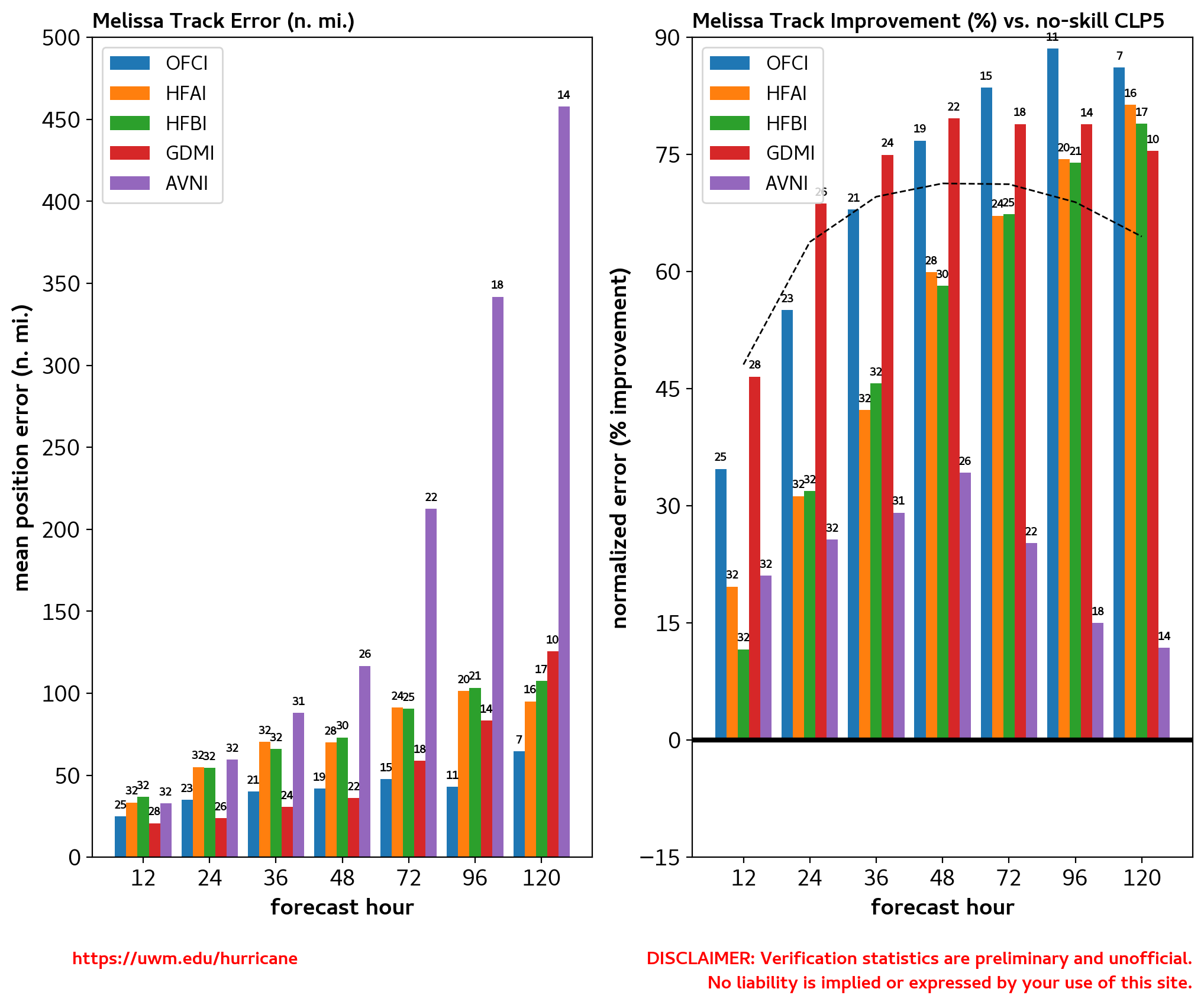
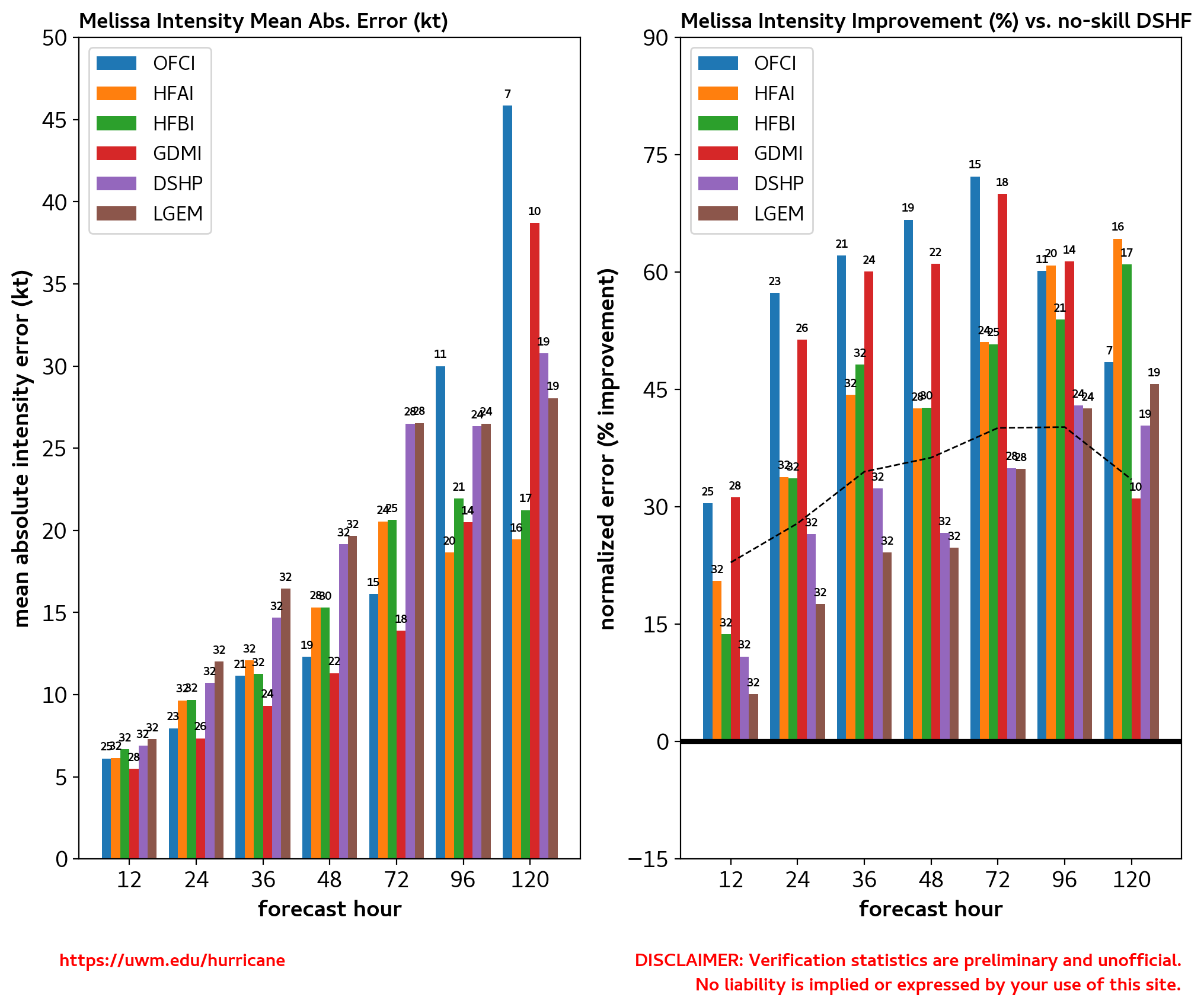
O NHC continua a cometer um pecado capital. Menciona sempre GFS (modelo) e não NCEP (instituto que o gere) mas continua a mencionar ECMWF (centro) ao invés de IFS (modelo). Da mesma forma, não é Google Deep Mind (centro) mas sim GraphCast (modelo).
O NHC tem ao seu dispor muitos modelos, que não aparecem no portal acima mencionado.
GDMI = GDM
AVNI = GFS
HFAI/B creio que é o HAFS, modelo de furacões mais recente.
OFCL = NHC
O GraphCast é um avanço muito relevante e atualmente outros modelos estão em desenvolvimento (AIFS do ECMWF, por exemplo). Esperançosamente trarão mais benefícios.
Já isto deve ser o WeatherNext Gen, que é o ensemble da Google Deep Mind.
Furacão Melissa quase estacionário por algumas horas voltou a movimentar-se, desta vez para NNE mas a uma velocidade à volta dos 4 Km/h. Melissa "passeia-se", literalmente, sobre águas quentes à volta dos 30ºC mas que já se nota estarem a ser lenta e gradualmente arrefecidas pela acção do ciclone tropical.
Olho com cerca de 18 Km de diâmetro, mantém categoria 5 com ventos máximos sustentados de 150 nós, cerca de 280 Km/h. Pressão desceu ligeiramente para 903hPa. Topo das nuvens extremamente frio, -90ºC. Sem sinais de substituição da parede do olho, como tipicamente acontece em ciclones tropicais tão intensos.
As imagens de satélite na banda 13, entre as 15:40 de ontem e as 3:50utc de hoje são impressionantes, e nas horas mais recentes mostram uma expansão da área de convecção profunda de topos extremamente frios.
«
"Slow-moving major hurricanes often go down in history as some of the deadliest and most destructive storms on record," he added. "This is a dire situation unfolding in slow motion."
Jamaica has seen many large hurricanes in the past, including Category 4 Hurricane Gilbert in 1988, but a direct hit from a Category 5 would be unprecedented, said Evan Thompson, of Jamaica's Meteorological Service.
Melissa is moving much slower than Gilbert, Jamaica's last major direct hit, Porter added, warning people should prepare to hunker down for days and some communities could be cut off for weeks.
Damian Anderson, a teacher from Hagley Gap, a town nestled in Jamaica's soaring Blue Mountains, said impassable roads had already cut off his community.
"We can't move," Anderson, 47, said. "We're scared. We've never seen a multi-day event like this before." »
Hurricane Melissa Discussion Number 27
NWS National Hurricane Center Miami FL AL132025
1100 PM EDT Mon Oct 27 2025
Both Air Force and NOAA Hurricane Hunter aircraft have been
investigating Melissa this evening. They found that the system
is maintaining category 5 intensity with the central pressure near
903 mb and peak 700 mb flight-level and tail Doppler radar winds
supporting 150 kt for the current intensity. The hurricane
continues to exhibit a well-defined eye about 10 n mi in diameter
embedded within extremely cold cloud tops to near -90 deg C.
Upper-level outflow remains well defined over the system. Although
such intense tropical cyclones typically undergo an eyewall
replacement, radar observations from Jamaica do not show this
occurring thus far.
After remaining nearly stationary over the past few hours, Melissa
now appears to be moving slowly north-northeastward with an initial
motion estimate of around 020/02 kt. During the next few days, a
mid-tropospheric trough is forecast to deepen near the southeastern
U.S. coast. This should result in Melissa moving
north-northeastward to northeastward with increasing forward speed
through the forecast period. The official forecast is similar to
the previous one and also close the tightly-clustered consensus and
Google DeepMind guidance. The only significant difference in the
track forecast compared to earlier today is a slower motion during
the first couple of days, which delays the expected arrival of the
core of Melissa over Jamaica, eastern Cuba, and the southeastern or
Central Bahamas.
Some fluctuations in intensity could still occur during the short
period before Melissa reaches Jamaica. The primary influence on
the hurricane's intensity during the next 36 hours will be the
interaction with land. Some weakening is anticipated after the
system moves over Jamaica and eastern Cuba. More substantial
weakening is likely after the system moves past Cuba and over the
southwestern Atlantic, where the vertical wind shear is likely to
increase significantly. The official intensity forecast is close
to the latest LGEM guidance.
Key Messages:
1. Jamaica: Remain in your safe shelter. Catastrophic flash flooding
and numerous landslides are expected through Tuesday. The eyewall’s
destructive winds may cause total structural failure, particularly
in higher elevations, leading to widespread infrastructural damage,
prolonged power and communication outages, and isolated communities.
Along the southern coast, life-threatening storm surge and damaging
waves are anticipated through Tuesday. Failure to take immediate
action may result in serious injury or significant loss of life.
2. Haiti and the Dominican Republic: Catastrophic flash flooding
and landslides are expected across southwestern Haiti and southern
portions of the Dominican Republic through midweek. In Haiti,
extensive infrastructural damage and isolation of communities is
likely. Tropical storm conditions are expected late Tuesday and
Wednesday.
3. Eastern Cuba: Heavy rainfall with life-threatening flash
flooding and landslides is expected to begin shortly.
Life-threatening storm surge and damaging winds are expected late
Tuesday and Tuesday night. Preparations should be rushed to
completion.
4. Southeast and Central Bahamas and the Turks and Caicos: Hurricane
conditions, life-threatening storm surge, and heavy rainfall are
expected across portions of the southeast and central Bahamas on
Wednesday. Residents should follow advice given by local officials
and be sure to have preparations complete by Tuesday night.
Tropical storm conditions, heavy rains, and a significant storm
surge is expected in the Turks and Caicos Islands on Wednesday.