Previsão e Seguimento Furacões (Atlântico 2007)

Mago

Nimbostratus
Registo
25 Out 2006
Mensagens
1,668
Local
Beira Interior
Informação Importante
Se chegou aqui pela primeira vez à procura de informação sobre a época de Furacões no Atlântico, consulte o tópico deste ano:
-> Previsão de Furacões Atlântico 2008


-------------------------------------

Previsão e seguimento de Furacões no Atlântico em 2007:

2007 vai ter muitos furacões

Cientistas norte-americanos previram hoje uma época de furacões em 2007 «muito activa» no Atlântico, com a formação de pelo menos 17 tempestades tropicais, nove das quais podem tornar-se ciclones.

«Antecipamos uma temporada ciclónica muito activa e a possibilidade de os furacões atingirem os Estados Unidos ultrapassa largamente a média», indicaram Philip Klotzbach e William Gray, da Universidade do Colorado (ocidente).

Os peritos avançam como explicação a dissipação do fenómeno «El Nino» que, ao aquecer as águas do Pacífico, tende a atenuar a actividade ciclónica no Atlântico.

Os cientistas estimam, paralelamente, que o fenómeno de arrefecimento no Pacífico chamado «La Nina» aumente a actividade ciclónica no Atlântico.

«Embora outros factores científicos afectem a frequência dos furacões, há uma tendência para registar um maior número de furacões no Atlântico durante o fenómeno La Nina», afirmou o vice-almirante Conrad Lautenbacher, que dirige a administração nacional encarregue dos oceanos.

Os especialistas consideram que a temporada dos furacões começa a 01 de Junho para terminar no final de Novembro.

O Centro Nacional dos furacões de Miami (Florida, sudeste) previra uma época de 2006 muito activa que acabou por não se concretizar, registando apenas nove tempestades tropicais, cinco das quais se tornaram furacões que causaram poucos estragos.

O ano de 2005 tinha sido particularmente mortífero com a passagem do furacão Katrina que devastou Nova Orleães e causou 1.500 mortos em três Estados do Sul (Luisiana, Alabama, Mississipi) e a do Stan que causou a morte de mais de um milhar de pessoas na Guatemala.

In PortugalDiário


Rog

Cumulonimbus
Registo
6 Set 2006
Mensagens
4,515
Local
Norte Madeira (500m)
Re: Epoca Furações 2007 (Atl. Norte)

A época de furacões do Atlântico Norte ainda nao começou ( 01-06-2007) mas já se fazem previsões:

Com o retorno da la-niña o cenário de mais furacões é uma possibilidade mto grande...
O el-niño desde o ano anterior foi fraco a moderado mas foi suficiente para termos uma temporada de furacões em 2006 bem fraquita, e já está a perder força tendo neste momento condições neutras com tendência para o se tornar la-niña.
Veremos, esta altura do ano não é das mais favoráveis a previsões, pelo menos no fenómeno El-niño...
 

Mago

Nimbostratus
Registo
25 Out 2006
Mensagens
1,668
Local
Beira Interior
Re: Epoca Furações 2007 (Atl. Norte)

Tenho a impressão também que também tem alguma coisa a ver com a intensidade da corrente do Golfo.
Se a corrente estiver mais enfraquecida, menos calor transporta pelas águas do atlãntico logo há menos fonte de energia para se formar um furacão.
Se reparar-mos uma grande parte dos furacões acompanha essa trajectória, inicia-se perto da zona Oeste de Cabo Verde e faz uma trajectória "boomerang" vai e volta.

Talvez não seja so o El Nino ou a El Nina que influenciam a época dos furacões.
 

Mário Barros

Furacão
Registo
18 Nov 2006
Mensagens
12,603
Local
Maçores (Torre de Moncorvo) / Algueirão (Sintra)
Re: Epoca Furações 2007 (Atl. Norte)

Este ano devemos ser batizados outra vez com um furacão o ano passado o Gordon constipou-se nas aguas ao pé dos Açores e perdeu a força toda mas este ano deve ocorrer o inverso :eek: :eek: a epoca de 2006 foi fraca este ano deve ser mais violenta as forças tem de se equilibrar mas claro a NOAA já o ano passado tinha-se fartado de dizer que o ano de 2006 ia ser violento e afinal não se passou praticamente nada.

E mais tarde ou mais cedo um furacão irá atingir Nova York e ai então toda a gente bota as mãos á cabeça e culpa o CO2 mas já se falava de um furacão atingir Nova York antes de haverem teorias malucas tal fenomeno já ocorreu no passado não custa nada voltar a reptir se tiver que ser.
 

Vince

Furacão
Registo
23 Jan 2007
Mensagens
10,624
Local
Braga
Re: Epoca Furações 2007 (Atl. Norte)

Todos os anos temos estas previsões e posteriores actualizações do William M. Gray e do seu colega Phil Klotzbach, ambos da Universidade de Colorado.

O Gray foi o pioneiro neste tipo de previsões e estas são muito importantes para a industria seguradora americana.

Esta última previsão deles aponta para uma temporada de furacões no Atlântico acima da média, mas não ao nível de 2005. Previram 17 tempestades com nome, das quais 9 serão furacões e 5 serão furacões muito intensos.
A média no Atlântio é de 10-6-2.

O documento completo pode ser encontrado aqui:

Extended Range Forecast of Atlantic Seasonal Hurricane Activity and U.S. Landfall Strike Probability for 2007
http://hurricane.atmos.colostate.edu/Forecasts/

Outra previsão respeitada desde género é a duma empresa inglesa, a Tropical Storm Risk (TSR), que também divulgou as previsões no mesmo dia:
http://tsr.mssl.ucl.ac.uk/
Os números são idênticos aos do Gray, neste caso são de 17-9-4


Mas sobre este tipo de previsões, o Jeff Masters do Wunderground escreveu um texto interessante no blogue dele, onde diz que estas previsões de Abril tem um valor quase nulo e mostra com números o porquê.

How accurate are the April forecasts?
I would have liked to have seen mentioned in today's forecast in big bold letters, "our past April forecasts have shown no skill in predicting Atlantic hurricane activity." Don't get me wrong--the CSU team are very skilled scientists, and I like the fact that they are trying to make useful seasonal hurricane forecasts. However, the skill of these April forecasts when compared to climatology is near zero, and they should be stating that in very clear terms in their April forecasts. In fact, CSU April forecasts from 1995-2006 have shown slightly negative skill.
http://www.wunderground.com/blog/JeffMasters/comment.html?entrynum=646&tstamp=200704
 

Vince

Furacão
Registo
23 Jan 2007
Mensagens
10,624
Local
Braga
Re: Epoca Furações 2007 (Atl. Norte)

O Jeff Masters apesar de dizer muitas vezes que Abril é demasiado cedo para grandes previsões, acaba no entanto de publicar a sua própria análise sobre os dados já disponíveis e que podem ser importantes no rumo da época de furacões deste ano, ou seja, básicamente fala da situação das SST's, do El Niño/La Niña e das tempestades de areia africanas.

2007 Atlantic Hurricane Season Outlook
It's too soon to find many clues about what the upcoming hurricane season might be like, since we are facing the famed "April Predictability Barrier". The atmosphere is not predictable enough to make a skillful forecast of seasonal hurricane activity in April (this changes by late May, when skillful predictions of the upcoming hurricane season CAN be made). Thus, we should put little faith in the predictions by the Klotzback/Gray group and TSR made in April, calling for 17 named storms, 9 hurricanes, and 4 or 5 intense hurricanes. However, there are a few indicators we can start looking at. I covered these in a talk I gave last week at Eckerd College in St. Petersburg that many of you asked to hear about, so here goes!

mar2007-mar2005sst.png

Figure 1. Sea Surface Temperature (SST) difference between March 2007 and 2005. Cool colors are regions where the SST was colder in 2007, and yellows and greens where SSTs were warmer in 2007. Image credit: NOAA/ESRL.

Sea Surface Temperature (SST) Outlook
Sea Surface temperatures are at the heart of any attempt to analyze seasonal hurricane activity, since SSTs change slowly and have a major impact on both the number of storms that form and their intensity. For example, the record-breaking Hurricane Season of 2005 had the warmest SSTs ever observed in the tropical Atlantic. Comparing the SSTs in March of 2007 with March of 2005 (Figure 1), we see that SSTs were more than 1 degree C cooler in 2007 over a large portion of the Atlantic west of the Lesser Antilles Islands. This is a key portion of the "Main Development Region" (MDR) for hurricanes (red box in Figure 1). The MDR is where 85% of all major hurricane form. Note, though, that the regions where Katrina, Rita, and Wilma formed--the Bahamas to the Western Caribbean--have SSTs warmer this year than in 2005. Overall, SSTs are well above average across most of the tropical Atlantic this year, continuing the pattern we have seen since 1995, when the current active Atlantic hurricane period began. We can expect this year's SSTs to support a more active than usual hurricane season, although there is still time for a significant cooling to occur if we get a major increase in the speed of the trade winds over the next few months.

april_nino3.4.gif

Figure 2. Sea Surface Temperature (SST) departure from average in the region 120°W-170°W, 5°S-5°N (called the Niño 3.4 region) for 2006 and 2007. Temperatures +0.5ºC above average in this region indicate an El Niño episode; temperatures -0.5ºC below average indicate an La Niña. Note that EL Niño peaked in December, then rapidly decayed to neutral conditions in early February. Image credit:NOAA Climate Prediction Center.

El Niño/La Niña Outlook
Obviously, SSTs don't tell the whole story, since the second highest SSTs in the tropical Atlantic since the 1870s occurred last year. To our great relief, we had a very normal year with 10 named storms, 5 hurricanes, and 2 intense hurricanes. As we see in Figure 2, that was in part because 2006 was an El Niño year. El Niño events usually suppress Atlantic hurricane activity, by bringing increased wind shear and dryer, sinking air over the Atlantic. This is not always the case--recall 2004? El Niño conditions were even stronger that year (as measured by SST departures from average in the Equatorial Pacific), yet that year saw 15 named storms, 9 hurricanes, and 6 intense hurricanes in the Atlantic. Florida got walloped with four hurricanes.

april_shearsstfct.png

Figure 3. Sea Surface Temperature (SST) departure from average (left) and wind shear departure from average (right) from the April 10, 2007 run of NOAA's CFS model. The forecasts are for the 3-month period August-October spanning the most active part of hurricane season. Note the long tongue of cooler than average waters forecast to extend from the South American coast along the Equatorial Pacific--the telltale sign of a La Niña episode. Image credit:NOAA Climate Prediction Center.

Regardless, El Niño is gone this year, and SSTs have been nearly average across the Equatorial Pacific since mid-February. Is El Niño likely to come back, or will its evil twin, La Niña strike this year? Well, according the early April run of NOAA's Climate Forecast System (CFS) model (Figure 3), we can expect a weak to moderate La Niña event during hurricane season (August-October). This should bring below average values of wind shear over the Atlantic, which should enhance hurricane activity. Other forecast models predict neutral conditions for hurricane season, and very few models foresee a return to El Niño conditions this year. NOAA's April 5 El Niño discussion indicates that the current pattern of ocean temperatures observed over the Equatorial Pacific is consistent with a developing La Niña event. The International Research Institute for Climate and Society is forecasting only a 10% chance of El Niño conditions during hurricane season in 2007. The chances of La Niña are put at 50%, and 40% for neutral conditions. What is the skill of these forecasts in April for an upcoming hurricane season? IRI doesn't tell us, but it's not good. Last year's April forecasts failed to predict the arrival of El Niño during hurricane season, leading to a large overestimation of hurricane activity. Still, the best information we have at this time says that El Niño is unlikely to occur during hurricane season, Since the active period of hurricane activity that we are in began in 1995, both La Niña and neutral years have seen very high levels of hurricane activity (Figure 4). In fact, calling La Niña an "evil twin" is not fair, since neutral years have had even higher hurricane activity than La Niña years (thanks in great measure to the Hurricane Season of 2005).

since1995.jpg

Figure 4. Observed numbers of named storms, hurricanes, and intense hurricanes (Category 3 and higher) for the 12-year period beginning in 1995. Background image is of Australia's Tropical Cyclone Monica, the most intense storm of 2006.

African dust outlook
African dust is thought to suppress Atlantic hurricane activity, although its role is not well understood. As I explained in a blog last year, research shows that the presence of drought conditions in the Sahel region of Africa the previous year will increase the amount of dust wafting over the Atlantic during hurricane season. This occurs because drought-damaged soil takes about a year to dry up and create lots of dust to be blown away. Last year saw average to above-average rains during the rainy season (June-September) over the Sahel (Figure 5). This was also the case in 2005, so in theory, two straight years of good rains in the Sahel should act to keep African dust levels over the Atlantic no higher than average this hurricane season. The last significant drought years in the Sahel were 2001 and 2002.

sahel_2006.png

Figure 5. Departure of precipitation from average in Africa for August 2006. The region in the red box is the Sahel region of Africa that accounts for most of the year-to-year variability in dust transport over the Atlantic Ocean. Image credit: NOAA Climate Prediction Center.

The outlook for the 2007 Atlantic hurricane season
If the forecasts of above normal sea surface temperatures, no El Niño, and below average African dust come true, the 2007 Atlantic hurricane season should be very active. However, since our skill in predicting these things in April is low, the most reasonable forecast to make is a post-1995 climatology forecast: 15 named storms, 8 hurricanes, and 4 intense hurricanes. (The 100-year climatology is 10 named storms, 6 hurricanes, and 2 intense hurricanes). By May, the atmosphere and ocean begin to give us significant clues about the upcoming hurricane season. Tune into the late May seasonal forecasts issued by NOAA, the Klotzback/Gray group, TSR, and Cuba's meteorological service!

My next blog will be Earth Day--Sunday, April 22. Next week, I also plan to review an article published today that hypothesizes that global warming should cause a significant increase in wind shear over the Atlantic and Eastern Pacific, inhibiting hurricanes.

Jeff Masters

Link: Dr. Jeff Masters' WunderBlog
 

Mago

Nimbostratus
Registo
25 Out 2006
Mensagens
1,668
Local
Beira Interior
Re: Epoca Furacões 2007 (Atl. Norte)

Pelo Mapa em cima de 2005 a 2007 o habitual roteiro dos furacões que vai desde a costa Oeste de Cabo Verde até aos Estados Unidos demonstra um aumento de temperatura de +0,5 a 2ºC o que vai energizar os furacões. No entanto parece-me que as águas mais perto da Europa continuam iguais o que vai continuar a servir de Travão a uma eventual ameaça séria.
Penso eu de que...:)
 

Vince

Furacão
Registo
23 Jan 2007
Mensagens
10,624
Local
Braga
Re: Epoca Furações 2007 (Atl. Norte)

De hoje a 4 semanas começa oficialmente a temporada de 2007.

A temperatura da água à superficie tem estado acima da média, e já começam a ter condições favoráveis (acima dos 26.5 C) para formação de depressões tropicais.

SST - Últimas semanas

atlsstgy5.gif


SST 3 Maio
Já se nota um belo corredor desde a Costa africana até ao golfo do México.

20oy3.jpg


Mas claro, para além da temperatura da água, faltam todas as restantes condições, wind-shear, vorticidade, baixas pressões, etc, etc.

Neste momento a probalidade é nula ou baixissima, como é perfeitamente normal:

probcq6.jpg
 

Vince

Furacão
Registo
23 Jan 2007
Mensagens
10,624
Local
Braga
Re: Epoca Furações 2007 (Atl. Norte)

Bem....

Ainda faltam umas semanas para Junho, as condições são muito desfavoráveis, mas parece que hoje há qualquer coisa para entreter....

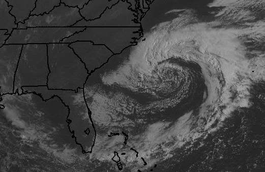
Vários modelos indicam a formação duma depressão a sueste do cabo Hatteras, e devido ao seu eventual movimento S ou SE poderá eventualmente adquirir características subtropicais.

Imagem satélite e a zona em questão:
satra9.jpg


huratlslpjr3.gif


Trajectorias: cada modelos, sua sentença
modeloslf7.jpg


O Jeff Master diz que a probalidade de estrear a temporada com o nome de Andreia é reduzida, na ordem dos 20%

Coastal Carolina storm
The latest (8pm EDT) computer forecast models continue to show a moderately strong coastal storm developing several hundred miles southeast of Cape Hatteras, North Carolina, on Monday. The storm will be extratropical in nature when it forms. We'll have a lot of time to watch the storm, as it is expected to meander offshore for five days and gradually weaken. Water temperatures are 22-23 C off of the coast, which may be warm enough to allow the low to acquire some subtropical characteristics and become the season's first named storm. The models are hinting that the storm could remain over water long enough for this to happen, and I put the odds of a Subtropical Storm Andrea forming late this week at about 20%.

Quando vi as imagens sobre isto, ainda pensei que pudessemos estar na presença de algo parecido com a tempestade tropical Ana de 2003, que também começou nesta zona e precocemente em finais de Abril, e que depois se dirigiu para Portugal.

150px-Ana_2003_track.png

Tropical Storm Ana (2003)
Ana formed as a subtropical storm on April 20 as a non-tropical low, and began taking on tropical characteristics. By April 21, Subtropical Storm Ana had developed a warm core and was designated a tropical storm. By April 24 it had become extratropical, and was absorbed by a frontal system near Portugal two days later. It was the only Atlantic storm ever to have formed in April in recorded history. A subtropical storm in the 1992 Atlantic hurricane season was the first recorded tropical or subtropical cyclone in April, although there have likely been other cyclones that were undetected
http://en.wikipedia.org/wiki/Tropical_Storm_Ana_(2003)
 

Vince

Furacão
Registo
23 Jan 2007
Mensagens
10,624
Local
Braga
Re: Epoca Furações 2007 (Atl. Norte)

Evolução da situação desde ontem.

Tal como os modelos previam, formou-se uma depressão a SE do cabo Hatteras.

xtrop.jpg


Para já obviamente não tem nada tem de sistema subtropical, além das águas demasiado frias (20C) e muita entrada de ar seco no sistema:
wvlpx0.jpg


Mas se nos próximos dias a depressão se deslocar para SW, vai apanhar água um pouco mais quente, sobre a zona da corrente do golfo, existindo assim a possibilidade, embora remota, de aquirir caracteristicas tropicais, evoluindo assim de um nucleo frio para um quente (Warm Core) com convecção bem mais forte.

20.jpg


Independemente de se vir ou não a tornar numa depressão subtropical ou mesmo tropical, não deixa de ser uma tempestade interessante, que talvez leve alguma chuva à Florida, onde tem havido muita falta de água nalgumas regiões.
Interessante, e poderosa, para quem anda no mar, como atestam os dados duma boia meteorológica mais proxima:

Station 41001 - 150 NM East of Cape HATTERAS
(7:50 am EDT)
Wind Direction (WDIR): ENE ( 70 deg true )
Wind Speed (WSPD): 42.7 kts
Wind Gust (GST): 52.4 kts
Wave Height (WVHT): 37.1 ft (11 metros ! )

MAYST0RM.jpg
 

Mago

Nimbostratus
Registo
25 Out 2006
Mensagens
1,668
Local
Beira Interior
Re: Epoca Furações 2007 (Atl. Norte)

As águas ainda estão um pouco frias no Atlãntico Norte, salvo lapso da minha parte o primeiro Furacão de 2006 já foi em Agosto ( Ernesto).
 

Vince

Furacão
Registo
23 Jan 2007
Mensagens
10,624
Local
Braga
Re: Epoca Furações 2007 (Atl. Norte)

As águas ainda estão um pouco frias no Atlãntico Norte, salvo lapso da minha parte o primeiro Furacão de 2006 já foi em Agosto ( Ernesto).

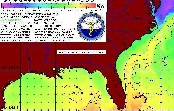
Sim, as águas estão muito frias,

sst5707.jpg


Mas se repares vês que a SW da tempestade há temperaturas um pouco mais altas, devido à nossa bem conhecida corrente do golfo.Em princípio a depressão dirige-se SW.

Mas é muito pouco provável que adquira características tropicais, ou seja, que ocorra uma transição para um warm core (centro quente).

De qualquer forma é um sistema que é sempre muito interessante para acompanhar e compreender a sua evolução.É uma verdadeira aula de ciclogénese tropical, perceber as condições que vão permitir ou impedir que o sistema adquira características tropicais.


Deixo aqui um pequeno texto em português do Metsul, a própósito de um caso brasileiro, mas que explica muito bem o que está em causa neste exemplo concreto:

Primeiro, o warm core (centro quente) que é típico de sistemas tropicais e o desenvolvimento da tempestade numa atmosfera baroclínica. Segundo, a formação do ciclone na região tropical e onde muito raramente há a visualização deste tipo de evento. O Centro Nacional de Furacões dos Estados Unidos (NHC) define ciclone tropical como "o ciclone de escala sinótica não frontal com centro quente, originado sobre águas tropicais ou subtropicais com convecção profunda organizada e uma circulação fechada junto a um centro bem definido. Uma vez formado, um ciclone tropical se mantém pela absorção de energia da temperatura elevada do mar e a exportação de calor na temperatura baixa da troposfera superior. Nisso se diferenciam dos ciclones extratropicais que têm sua energia derivada de contrastes horizontais de temperatura na atmosfera (efeitos baroclínicos)". Já os ciclones subtropicais têm características tanto de um sistema extratropical como tropical, podendo apresentar um warm core (núcleo quente). Podem se apresentar na forma de uma baixa fria em altos níveis da atmosfera com o raio de vento forte se estendendo por uma região muito grande. Por outro lado, se dão também a partir de um sistema de baixa pressão de mesoescala dentro ou próximo a uma zona de divergência de vento em frontólise (frente fria em dissipação). Estas baixas de mesoescala tanto podem ter centro quente como frio.
http://www.metsul.com/blog/?cod_blog=1&cod_publicacao=75

Mais outros textos, em inglês, sobre esta tempestade concreta:

SUNDAY 10:30 A.M. THE CASE FOR CONVERSION TO WARM CORE.
In a way, the GFS is saying this will happen. One has to remember that warm core would mean dry subsiding air in the middle of a storm that is surrounded by air that is cooler. The mechanism to sustain the storm then becomes forced, rather than baroclinically induced. In other words, at first it is the mixing of cold and warm air in a way that causes upward motion to develop the storm, but once the storm develops and the temperature gradient fades, the input of energy is driven by strong long-level winds over warm moist water that rises as it approaches the center. This releases heat up and out of the storm, but an areas of sinking develops in the center of storm because of the air going up so quickly as it approaches. The process is helped along by the existence of dry air anyway which, like gulls in the eye of the storm, gets caught there, so we open up the dry center.

The conversion to a warm core system is one that has always been a mystery and causes great wailing and gnashing of teeth. For instance, Karen a few years ago blasted Bermuda, but was not declared a tropical cyclone until the recon got in and found out what many of us knew, that no storm causing winds to 80 mph over 83-degree water in September is cold core, even though its origins were. The solution of course is to develop a result-based criteria; in other words, closed rotary circulation with sustained gales in one quad over water warmer than 25c, name it. Chances are with that type of convergence to cause that, over water that warm, if it's not warm core, it will be soon. In addition, unsuspecting boaters in the warm water areas of our coasts will be warned in advance, as I am trying to do now for people along the southern Atlantic coast.

The most interesting aspect as far as the GFS now goes is IT IS PREDICTING THIS TO BECOME WARM CORE. How so? 1) The fronts disappear. 2) It is moving it west-northwest and not in some small look but instead for a few hundred miles, so much so it actually takes it back to the coast. 3) It WEAKENS it as it reaches the cooler water and goes over land. Baroclinic systems usually move northeast and intensify with time not west-northwest and weaken as they hit land.
http://wwwa.accuweather.com/news-blogs.asp?partner=accuweather&traveler=0&blog=community

Coastal Carolina storm
A powerful non-tropical low pressure system formed off the coast of North Carolina last night, and is bringing tropical storm-force winds as high as 55 mph to the waters offshore the Carolina coast, according to the latest QuikSCAT satellite wind estimates. The North Carolina Diamond Shoals buoy had 17 foot seas and sustained winds of 43 mph at 9am EDT this morning, and buoy 41001 about 175 miles east of Cape Hatteras recorded sustained winds of 62 mph gusting to 80 mph at 1am this morning. Seas were 41 feet at this buoy this morning! The strong winds will bring 10-20 foot seas and significant beach erosion to the shores of North Carolina, South Carolina, and northeast Florida through Wednesday. A 3-5 foot storm surge is expected along portions of the North Carolina coast through Tuesday morning. The latest set of computer model runs have the storm drifting slowly southwest, and bring it ashore between the South Carolina and northern Florida coast on Wednesday. The storm will start to develop thunderstorm activity and a warm core, but will probably not have time to become fully subtropical and become Subtropical Storm Andrea. However, the storm is only expected to weaken slowly, and will have an impact similar to a tropical storm in regards to offshore winds and coastal flooding today and Tuesday. If the storm does indeed make landfall on Wednesday as expected, it will most likely be of tropical depression strength, with top sustained winds around 30-35 mph. Heavy rains of 1-3 inches can be expected to the north of where the center makes landfall, but rains will not be as significant as what a tropical storm would bring.
http://www.wunderground.com/blog/JeffMasters/show.html

Subtropical cyclone
Most subtropical cyclones form when a deep cold-core extratropical cyclone drops down into the subtropics. The system becomes blocked by a high latitude ridge, and eventually sheds its frontal boundaries as its source of cool and dry air from the high latitudes diverts away from the system. Temperature differences between the 500 hPa pressure level, or 6000 meters/20000 ft above ground level, and the sea surface temperatures initially exceed the dry adiabatic lapse rate, which causes an initial round of thunderstorms at a distance east of the center. Due to the initial cold temperatures aloft, sea surface temperatures usually need to reach at least 20 degrees C for this initial round of thunderstorms. The initial thunderstorm activity moistens up the environment around the low, which destabilizes the atmosphere by reducing the lapse rate needed for convection. When the next shortwave or upper level jet streak moves nearby, convection reignites closer to the center and the system develops into a true subtropical cyclone. The average sea surface temperature that helps lead to subtropical cyclogenesis is 24 degrees C.[2] If the thunderstorm activity becomes deep and persistent, allowing its initial low level warm core to deepen, tropical cyclogenesis is possible.
http://en.wikipedia.org/wiki/Subtropical_cyclone


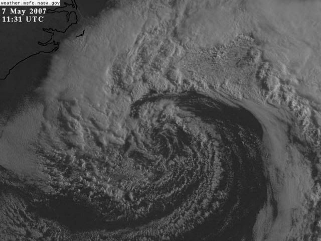
Últimas imagens Satélite:

GOES16452007127vx9wcl.jpg


stormbo5.jpg
 

Vince

Furacão
Registo
23 Jan 2007
Mensagens
10,624
Local
Braga
Re: Epoca Furações 2007 (Atl. Norte)

O sistema continua a sua curiosa evolução. Já se libertou daquele "braço" frontal, e apresenta já algumas características de pelo menos sistema subtropical. Já há algumas trovoadas nas nuvens em redor do centro, embora estas nuvens estam demasiado dispersas. tecnicamente uns chamam-lhe sistema hibrido, outros Baixa Oclusa.

Ao longo do dia de hoje chegará a águas um pouco mais quentes, mas alguns modelos colocam-na num trajecto para oeste, e não estará tempo suficiente sobre água para se fortalecer grande coisa. Mas quem sabe...

08:15 UTC
satbc3.jpg


Anim até às 09:15
animxn5.gif


Vapor de água 09:46
A parte central já se livrou da injecção de ar seco que sofreu durante todo o dia de ontem, agora apresenta maior humidade.
huwvge7.jpg
 

Vince

Furacão
Registo
23 Jan 2007
Mensagens
10,624
Local
Braga
Re: Epoca Furações 2007 (Atl. Norte)

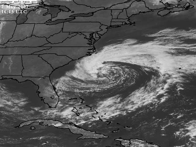
Última imagen:
Do lado esquerda da imagem vêm-se vários incêndios na Florida e na Georgia, Estados que atravessam uma grande seca. Enquanto a chuva não chega, o vento tem dificultado o combate às chamas.

Não deixa de ser irónico que ao contrário que se vai passar daqui a poucas semanas ou meses, esta tempestade é deseperadamente desejada por causa da chuva.

goes12452007128knygt3na1.jpg


Entretanto, já começou a discussão nos EUA se o NHC já não deveria ter considerado o sistema subtropical e ter-lhe dado um nome, pois a tempestade apresenta ventos e ondas não desprezáveis.

A opinião de muitos é que noutra altura do ano teria nome, mas o NHC vai adiar até à última tal hipotese porque não sendo uma tempestade muito perigosa, dar-lhe um nome geraria a inevitável histeria mediática de uma tempestade tropical em princípios de Maio.

As of 9:00AM EDT, the subtropical system has yet to be named by NHC. It is slowly but steadily transitioning to a tropical system as convection continues to build around its center of circulation. Tropical transition can be a long process (often in excess of 48 hours) in a dry environment and in this case the subtropical system probably won't have time to fully transition before landfall, but should get close. The more recent satellite imagery is posted and discussion continues below. Notice that the more recent water vapor image (2nd image vs 3rd image) is showing deeper blues and more convective cells wrapping around the center, indicating more moisture and a more tropical storm.

As a meteorologist today is one of those days where I am glad that I am not a decision maker at the National Hurricane Center. The subtropical storm that is drifting off the coast of the Carolinas is truly a tough call for those at NHC. If NHC names this system they will instantly be faced with a pre-season hurricane only a couple hundred miles off the U.S. coast and many people will panic and be angry about a perceived lack of warning. Due to this societal constraint, it seems unlikely that NHC will name this system. If it were October right now, I have no doubt that their decision would be different. Instead the National Weather Service is taking a more diplomatic approach and has issued Hurricane Force Wind Warnings. However, in my professional opinion we are absolutely dealing with at least a subtropical storm at this time.

A quick look at the water vapor satellite image clearly shows an increasingly tropical form. This image looks like a classic subtropical system undergoing "tropical transition" into a purely tropical system. In the words of NHC forecaster Dr. Knabb is his Discussion 2 from Vince in 2005: "If it looks like a hurricane... it probably is... despite its environment and unusual location."
http://www.thestormtrack.com/2007/05/preseason_subtropical_storm.php

Pelo sim, pelo não, já está agendado um voo de reconhecimento para amanhã de manhã. Conforme a evolução do dia de hoje e noite, será ou não feito.
NOUS42 KNHC 081330
WEATHER RECONNAISSANCE FLIGHTS
CARCAH, NATIONAL HURRICANE CENTER, MIAMI, FL.
0930 AM EDT TUE 08 MAY 2007
SUBJECT: TROPICAL CYCLONE PLAN OF THE DAY (WSPOD)
VALID 09/1100Z 10/1100Z MAY 2007
WSPOD NUMBER.....07-001

I. ATLANTIC REQUIREMENTS
1. FLIGHT ONE AREA OFF SOUTH CAROLINA
A. 09/1200Z
B. AFXXX 01AAA INVEST
C. 09/0930Z
D. 31.8N 79.4W
E. 09/1100Z-09/1800Z
F. SFC TO 10,000FT

2. OUTLOOK FOR SUCCEEDING DAY.....NEGATIVE