Previsão e Seguimento Tufões (Pacífico Oeste 2019)
- Thread starter luismeteo3
- Data de início
-
O novo portal está no ar! Novos meteogramas, cartas, e mais. Mais informações neste tópico
Seguimento Meteorológico: Litoral Norte | Interior Norte e Centro | Litoral Centro | Sul | Açores e Madeira | Livre
Previsões: Curto e médio prazo: até 2 semanas | Longo prazo: mensal e sazonal (Regras e links úteis nos 1ºs posts)
Facebook | Avisos IPMA/Alertas ANEPC
You are using an out of date browser. It may not display this or other websites correctly.
You should upgrade or use an alternative browser.
You should upgrade or use an alternative browser.


UW-CIMSS Automated Satellite-Based
Advanced Dvorak Technique (ADT)
Version 9.0
Current Intensity Analysis
UW - CIMSS
ADVANCED DVORAK TECHNIQUE
ADT-Version 9.0
Tropical Cyclone Intensity Algorithm
----- Current Analysis -----
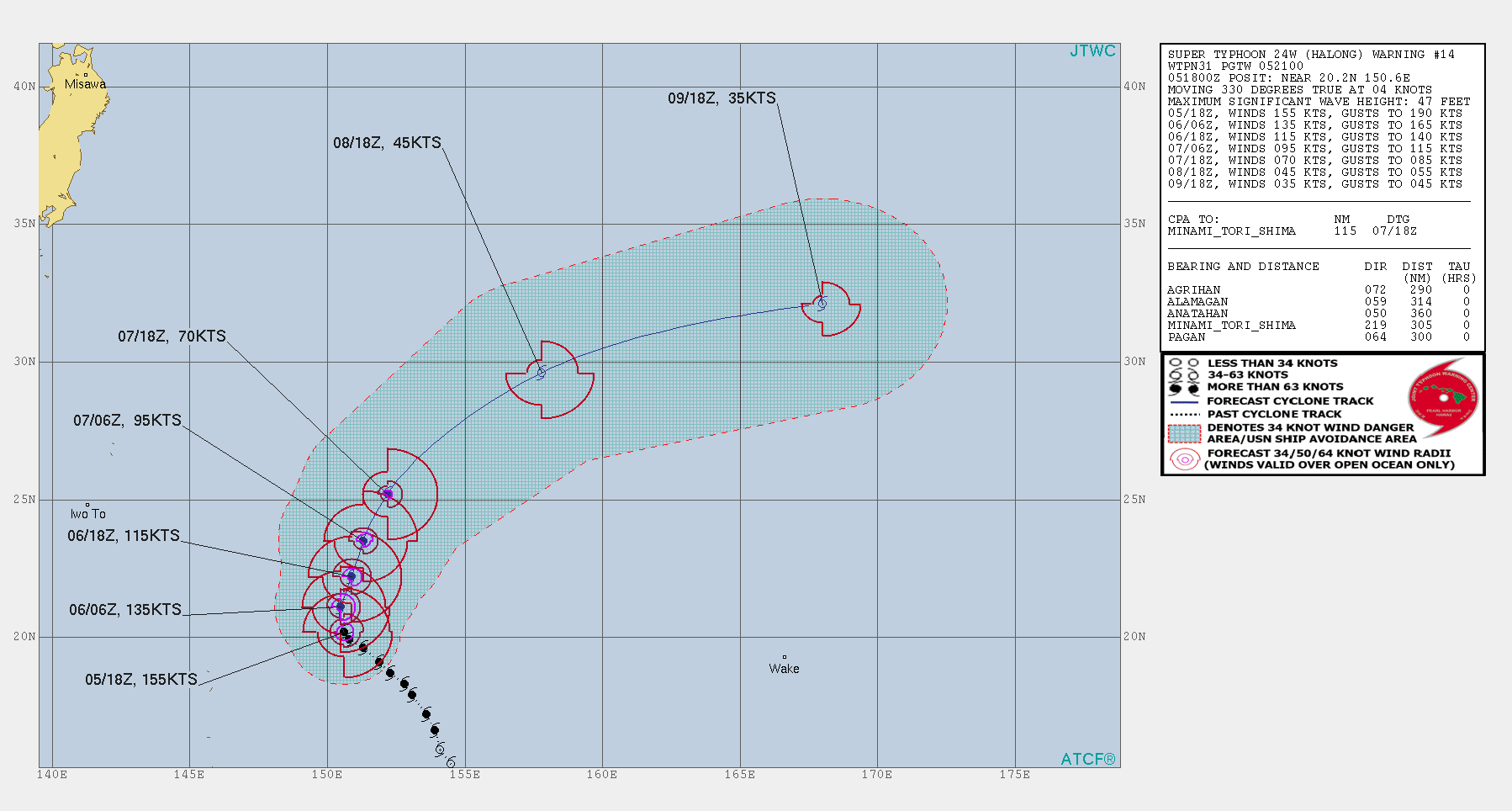
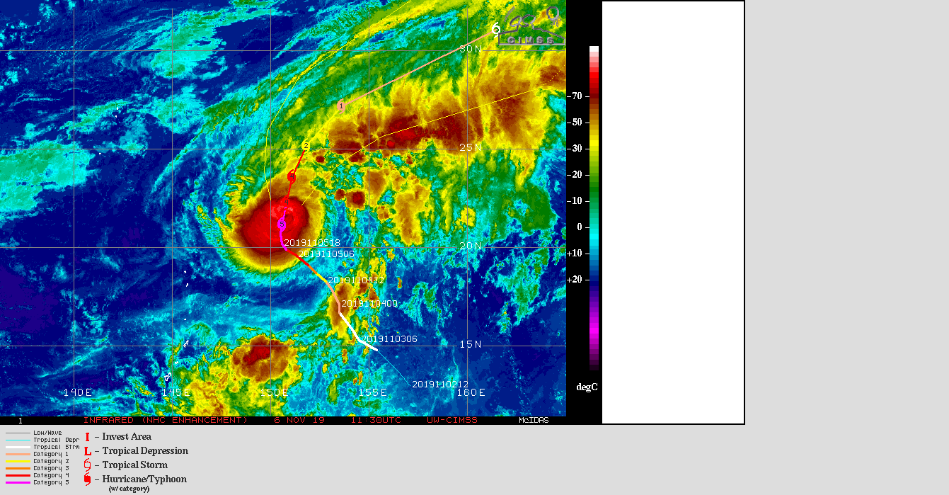
Date : 05 NOV 2019 Time : 184000 UTC
Lat : 20:23:23 N Lon : 150:34:12 E
CI# /Pressure/ Vmax
7.8 / 894.1mb/164.0kt
Final T# Adj T# Raw T#
7.7 7.7 7.7
Advanced Dvorak Technique (ADT)
Version 9.0
Current Intensity Analysis
UW - CIMSS
ADVANCED DVORAK TECHNIQUE
ADT-Version 9.0
Tropical Cyclone Intensity Algorithm
----- Current Analysis -----
Date : 05 NOV 2019 Time : 184000 UTC
Lat : 20:23:23 N Lon : 150:34:12 E
CI# /Pressure/ Vmax
7.8 / 894.1mb/164.0kt
Final T# Adj T# Raw T#
7.7 7.7 7.7
Japan Meteorological Agency
Tropical Cyclone Advisory #19 - 3:00 AM JST November 14 2019
SEVERE TROPICAL STORM FENGSHEN (T1925)
========================================
Minami-tori shima waters
At 18:00 PM UTC, Severe Tropical Storm Fengshen (996 hPa) located at 16.5N 152.4E has 10 minute sustained winds of 50 knots with gusts of 70 knots. The cyclone is reported as moving west at 8 knots.
Gale Force Winds
=============
150 nm from the center in northwestern quadrant
90 nm from the center in southeastern quadrant
Dvorak Intensity: T3.5
Forecast and Intensity
===============
24 HRS: 17.7N 146.3E - 65 knots (CAT 3/Strong Typhoon) northeast of Northern Mariana Islands (Alamagan)
48 HRS: 22.0N 143.9E - 80 knots (CAT 3/Strong Typhoon) seas near Ogasawara islands
72 HRS: 26.1N 148.9E - 70 knots (CAT 3/Strong Typhoon) Minami-tori shima waters
---------------------------------------------------------
Tropical Cyclone Advisory #17 - 3:00 AM JST November 14 2019
TROPICAL STORM KALMAEGI (T1926)
========================================
Sea East of the Philippines
At 18:00 PM UTC, Tropical Storm Kalmaegi (1000 hPa) located at 13.6N 127.1E has 10 minute sustained winds of 35 knots with gusts of 50 knots. The cyclone is reported as moving north northwest at 7 knots.
Gale Force Winds
=============
300 nm from the center in northwestern quadrant
120 nm from the center in southeastern quadrant
Dvorak Intensity: T2.5-
Forecast and Intensity
===============
24 HRS: 15.4N 125.0E - 45 knots (CAT 1/Tropical Storm) sea east of the Philippines
48 HRS: 16.4N 124.8E - 50 knots (CAT 2/Severe Tropical Storm) sea east of the Philippines
72 HRS: 16.8N 123.7E - 60 knots (CAT 2/Severe Tropical Storm) sea east of the Philippines
Japan Meteorological Agency
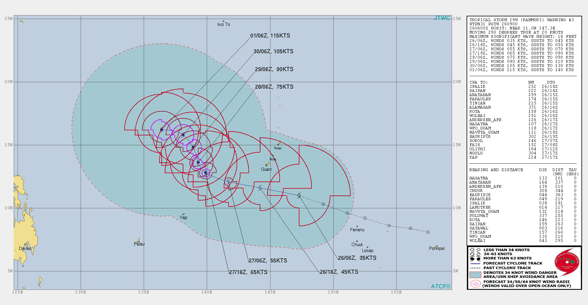
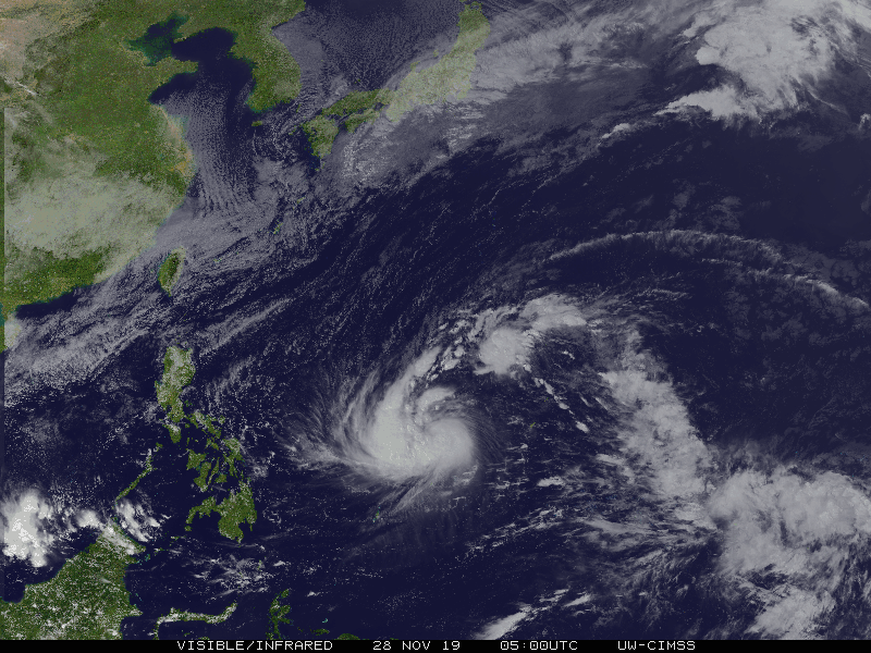
Tropical Cyclone Advisory #23 - 15:00 PM JST November 28 2019
TYPHOON KAMMURI (T1928)
=======================================
Sea East of the Philippines
At 6:00 AM UTC, Typhoon Kammuri (970 hPa) located at 12.7N 138.5E has 10 minute sustained winds of 70 knots with gusts of 100 knots. The cyclone is reported as moving northwest at 6 knots.
Storm Force Winds
==============
50 nm from the center
Gale Force Winds
=============
300 nm from the center in northern quadrant
150 nm from the center in southern quadrant
Dvorak Intensity: T4.5-
Forecast and Intensity
==================
24 HRS: 14.5N 138.0E - 85 knots (CAT 4/Very Strong Typhoon) Sea east of the Philippines
48 HRS: 14.2N 135.7E - 95 knots (CAT 4/Very Strong Typhoon) Sea east of the Philippines
72 HRS: 14.1N 131.7E - 100 knots (CAT 4/Very Strong Typhoon) Sea east of the Philippines (Camarines Sur)
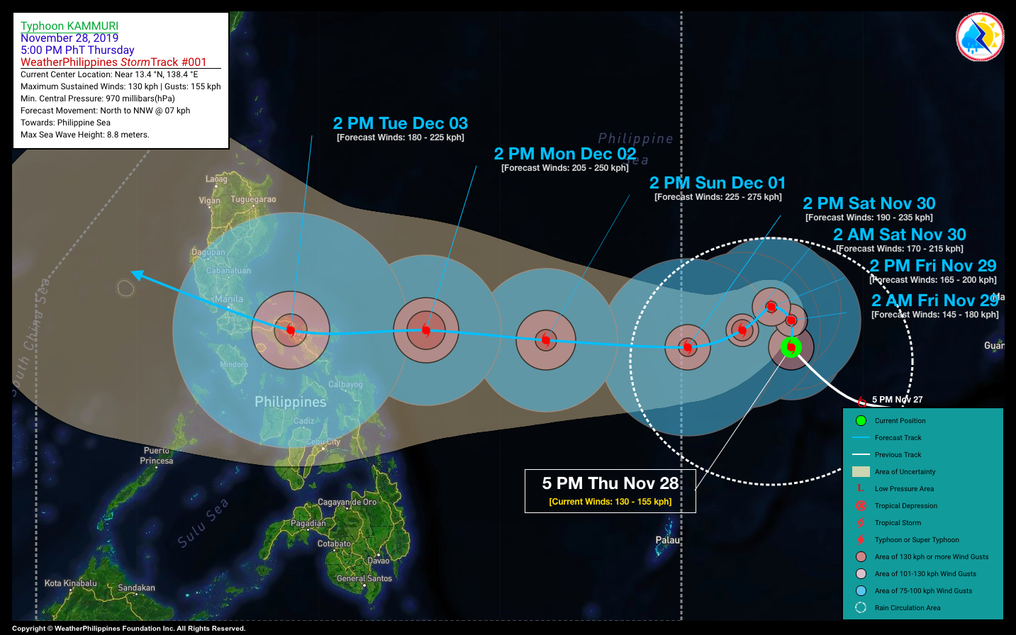
Já é Categoria 1... mas vai rapidamente fortalecer para categoria 4 ou 5 e atingir as Filipinas...
Candy
Cumulonimbus
Japan Meteorological Agency
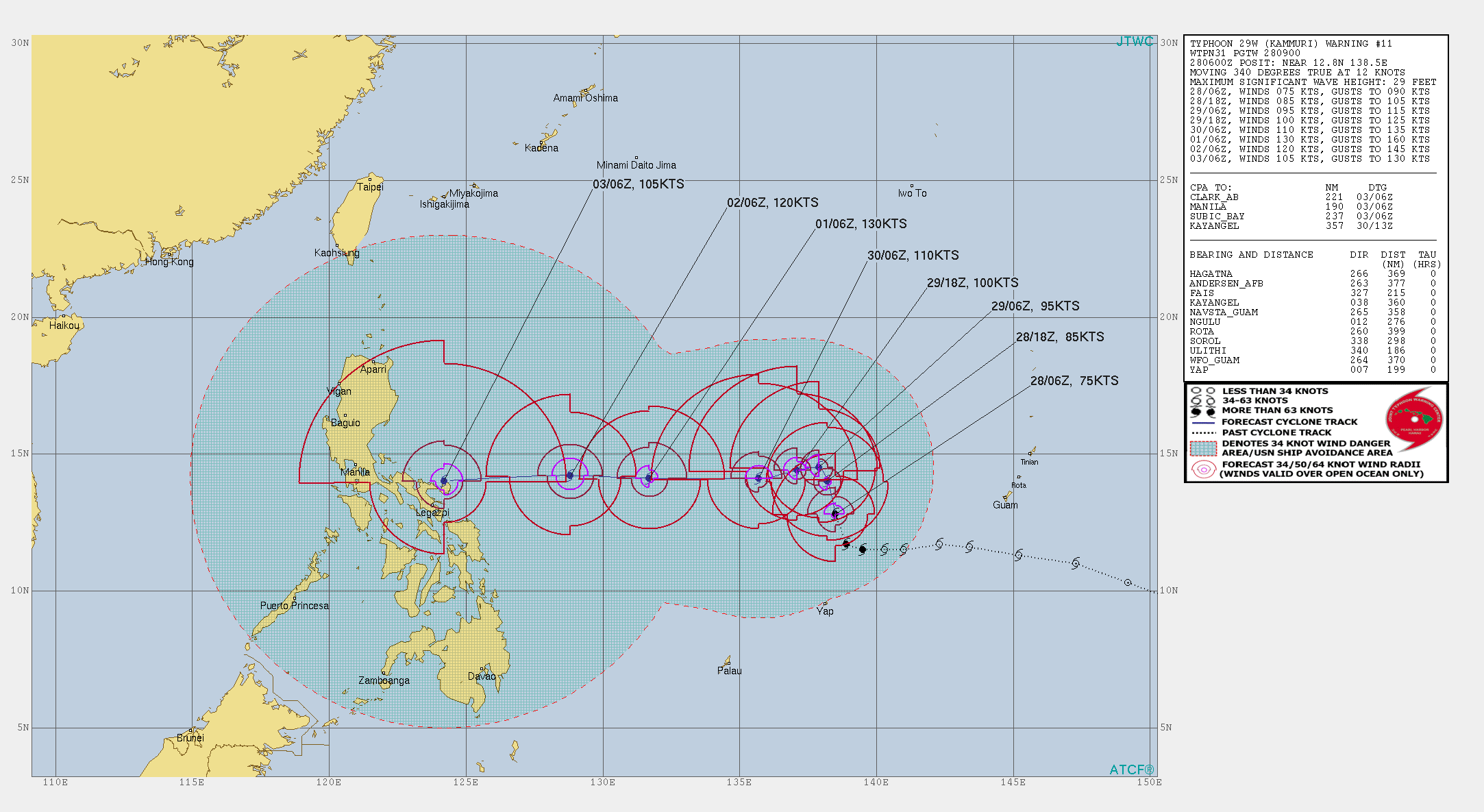
Tropical Cyclone Advisory #35 - 3:00 AM JST November 30 2019
TYPHOON KAMMURI (T1928)
=======================================
Sea East of the Philippines
At 18:00 PM UTC, Typhoon Kammuri (955 hPa) located at 13.8N 136.5E has 10 minute sustained winds of 80 knots with gusts of 115 knots. The cyclone is reported as moving west slowly.
Storm Force Winds
==============
70 nm from the center
Gale Force Winds
=============
270 nm from the center in northwestern quadrant
180 nm from the center in southeastern quadrant
Dvorak Intensity: T5.0-
Forecast and Intensity
==================
24 HRS: 13.1N 132.5E - 90 knots (CAT 4/Very Strong Typhoon) Sea east of the Philippines
48 HRS: 13.3N 127.9E - 100 knots (CAT 4/Very Strong Typhoon) Sea east of the Philippines
72 HRS: 13.6N 123.7E - 100 knots (CAT 4/Very Strong Typhoon) Luzon region (east of Camarines Sur)
Última edição: