Previsões médio prazo (até 2 semanas) - Outubro 2018

Orion

Furacão
Registo
5 Jul 2011
Mensagens
21,567
Local
Açores
:D

80Fq7Tf.gif


O cisalhamento é muito elevado, inviabilizando a ocorrência de um furacão. Ainda assim, não se pode excluir uma TT, que poderia ser na mesma desastroso.

Gvq217h.png
 
Última edição:


Orion

Furacão
Registo
5 Jul 2011
Mensagens
21,567
Local
Açores
GKNVMqN.gif


Daqui a uns 30/35 minutos será publicado o aviso 45. Dificilmente haverão informações críticas para os madeirenses.

Nos próximos 2/3 dias, o CT Leslie irá novamente passar por águas conhecidas (trajeto passado -> linha preta).

qtQLzfq.png


Com tanta mudança, a Leslie ainda se vai dissipar antes de chegar à Madeira :D
 

Hawk

Cumulonimbus
Registo
26 Nov 2006
Mensagens
2,272
Local
Funchal
Estamos a falar de um potencial cenário mas só daqui a uma semana. Não vale a pena sofrer por antecipação já que ainda existe grandes discrepâncias nos modelos no que toca à rota da tempestade ( ou se ela sequer resiste à chegada a águas madeirenses). Quando houver mais confiança as autoridades emitirão comunicado.
 

Fada

Cumulus
Registo
3 Out 2015
Mensagens
109
Local
Algarve
Estamos a falar de um potencial cenário mas só daqui a uma semana. Não vale a pena sofrer por antecipação já que ainda existe grandes discrepâncias nos modelos no que toca à rota da tempestade ( ou se ela sequer resiste à chegada a águas madeirenses). Quando houver mais confiança as autoridades emitirão comunicado.

Ok, obrigada.:)
 

Aurélio Carvalho

Nimbostratus
Registo
5 Out 2018
Mensagens
1,821
Local
Faro
Boa tarde
Por aquilo que eu vejo nos modelos e parecendo de grosso modo q muita da potencial instabilidade depende do comportamento da Leslie todis os cenários continuam em aberto. Mas neste é assumindo que a Leslie não se dissipa a maioria dos cenários aponta para a Leslie ir em direcção a madeira embora ainda seja duvidoso q não se dissipara antes da sua chegada.
Em relação ao continente este mês parece estar com tendência a poder ser seco em boa parte do território.
 

Orion

Furacão
Registo
5 Jul 2011
Mensagens
21,567
Local
Açores
O GEFS voltou ao cenário Opheliano :wacko:

C58RIzJ.gif


Falta 1 hora para o aviso 46. Do aviso 45 (15h UTC) tira-se isto:

However, by 36 h, nearly all of the dynamical models, both global and regional, forecast that Leslie will begin to restrengthen. On the other hand, the statistical-dynamical models do not forecast much change through day 5. The NHC forecast has been adjusted a little higher to keep it close to the intensity consensus, and I can't rule out that Leslie could become a hurricane again at some point during the coming week.

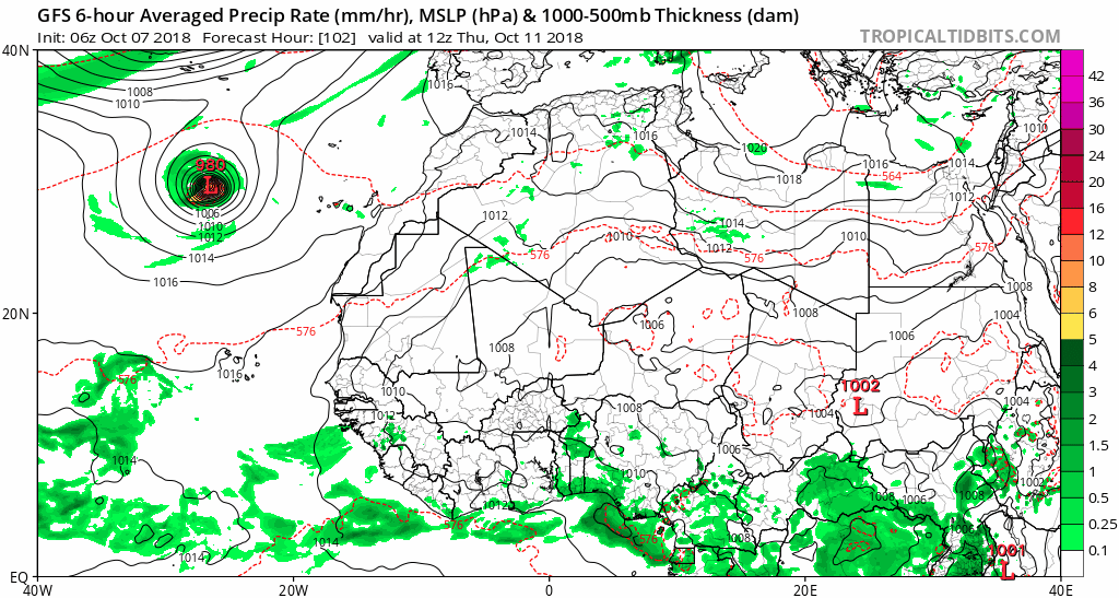
The track model spread is high from the very beginning of the forecast (...) The track forecast variance stems from differences in how quickly the models show Leslie separating from a mid-level trough to its north, if at all, and by day 5, the GFS and ECMWF solutions vary by about 750 n mi. At this point, I don't have a good reason to pick one solution over another, and it should be noted that based on the ECMWF ensemble tracks, there is a whole spectrum of possible solutions between these extremes.

As previsões dos modelos disponíveis ao NHC não mudaram muito desde as 12h. Nos modelos globais há consenso na posição do ciclone a 144h. Já para a intensidade ainda é muito cedo.

DQmLZZn.gif
 
Última edição:

Orion

Furacão
Registo
5 Jul 2011
Mensagens
21,567
Local
Açores
Do aviso 46:

Beyond 48 h, the intensity guidance is now in better agreement that some intensification will occur, and Leslie is forecast to become a hurricane once again by the end of the week.

Most of the global models still forecast that Leslie will separate from the trough in a few days and turn southeastward, and there are still large differences on exactly when that will occur. The deterministic runs of the GFS and ECMWF have come into better agreement on the future track of Leslie, but the ensembles of those models indicate that the range of possible tracks hasn't actually decreased. Confidence in the track forecast therefore remains quite low.

Para simplificar a compreensão do EPS (que na publicação anterior está muito confusa):

Hu8zaqK.gif


Em alguns membros o ciclone faz uma curva e afasta-se da Madeira quando está muito próximo da ilha. Em outros a curva é feita mais tarde e/ou mais longe. O cenário (opheliano) predominante no GEFS não tem muito apoio no EPS.
 

Orion

Furacão
Registo
5 Jul 2011
Mensagens
21,567
Local
Açores
Parece que, à semelhança do Ophelia, o CT Leslie vai passar ao largo dos Açores enquanto furacão ou lá perto. A transição ocorrerá depois.

Tanto no IFS como no GFS o ciclone está muito cisalhado.

6MuLl8x.png


kClYqQc.png


Ainda assim é melhor esperar um pouco não vá aparecer um cat. 2 :D

3rJ6b8R.png
 

Orion

Furacão
Registo
5 Jul 2011
Mensagens
21,567
Local
Açores
Aviso 51:

Models continue to be in poor agreement on whether that trough will accelerate Leslie quickly to the northeast at long range or drop the cyclone to the southwest of Portugal. The recent GFS-based guidance has generally shifted southward and is slower, more in line with the 12Z UK/ECMWF models. The new NHC forecast follows that trend, but is still on the northern side of the consensus due to continuity concerns, and additional southward adjustments could be required on later advisories.

By day 5, increasing shear and cold waters should weaken Leslie, and it will probably lose convection to transition into a post-tropical cyclone.

lzPSq2Q.gif


Bastante degradada a Leslie.