Previsão do Estofex
Storm Forecast
Valid: Thu 18 Aug 2011 06:00 to Fri 19 Aug 2011 06:00 UTC
Issued: Wed 17 Aug 2011 21:49
Forecaster: GATZEN
A level 2 was issued for portions of France and south-western Germany mainly for severe wind gusts and large hail.
A level 1 was issued for portions of Spain, southern Portugal, France, the Alpine region, Germany, and the Benelux countries mainly for severe wind gusts and large hail.
SYNOPSIS
To the north of a broad ridge over the Mediterranean, a strong westerly flow affects portions of Europe in the wake of a short-wave trough stretching from Scandinavia to western Russia. Another short-wave trough will migrate into Central Europe during the period. This will be associated with the advection of warm and unstable air into southern Germany.
DISCUSSION
Northern Spain into France and Germany, Alps
A warm air mass is present over south-western Europe, characterized by steep mid-level lapse rates. The overlap with rich boundary-layer moisture near a warm front over France and northern Italy leads to CAPE in the order of 1000 J/kg. On Thursday, this warm air mass will spread north-eastward into the Alps, most of France, and southern Germany as indicated by latest models. Ahead of an approaching cold front, the low-level moisture is forecast to increase especially over France and south-western Germany, where CAPE of 1000 J/kg seems to be likely even with limited insolation.
Early showers and thunderstorms are forecast along the frontal boundary from central and northern France to central Germany. In the afternoon hours, increasing QG forcing is expected to lead to cyclogenesis over northern France, and models indicate a deepening surface low spreading north-eastward across Germany in the evening hours. Strong low-level convergence will assist for numerous thunderstorms that will likely merge into clusters, spreading eastward.
Severe thunderstorms are forecast over a broad area as the mid-level flow will strengthen, leading to a deep layer bulk shear of 15 to 20 m/s. This will enable well-organized thunderstorms including supercells especially to the north of the Pyrenees, where favourably veering profiles are most likely. Large or very large hail is expected to be the dominant threat across the southern portions of the risk area, and severe gusts or tornadoes will be less likely. A few events are not ruled out, though, as the low-level vertical wind shear increases in the evening hours.
From central/northern France to south-western/central Germany, stronger dynamics are forecast to compensate the weaker instability. Strong low-level convergence near the frontal boundary and the low-pressure centre will likely support deep convection that may be elevated to the north of the warm front. Storms that root to the boundary-layer will encounter strong vertical wind shear and will likely organize into bowing segments or supercells. Severe wind gusts are forecast. In the evening hours, strong low-level vertical wind shear is forecast to favour tornadoes. Large hail is not ruled out with the most intense storms.
The storms are expected to cluster along the cold front spreading across Germany in the night hours, while the severe threat will gradually decrease due to stabilization. Along the southern portions of the frontal boundary from south-western Germany across central France, ongoing convective activity is expected to pose a slight threat of large hail through-out the night.
Southern Spain / Portugal
Ahead of the low geopotential over the Atlantic, a south-easterly flow evolves over Spain, advecting an elevated mixed layer north-westward. Increasing boundary-layer moisture will enable rather high instability over southern Spain and Portugal. Additionally, 15 m/s deep layer vertical wind shear will be in place. Main uncertainty is the forcing that may increase during the night hours along the nose of a low-level jet evolving over southern Iberia at the end of the period. Isolated storms are forecast that will pose a threat of large or very large hail.
Fonte: Estofex
O Estofex prevê no Sul do país, situações isoladas de tempestades com granizo de grandes dimensões.
 Não concordo, vendo os mapas de precipitação colocado no IM, não vejo nada de boa saída, só chuva no interior do país e o litoral não vê nada.
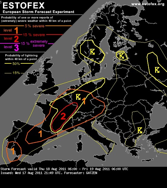

")