Seguimento Sul - Agosto 2011
- Thread starter Spider
- Data de início
-
O novo portal está no ar! Novos meteogramas, cartas, e mais. Mais informações neste tópico
Seguimento Meteorológico: Litoral Norte | Interior Norte e Centro | Litoral Centro | Sul | Açores e Madeira | Livre
Previsões: Curto e médio prazo: até 2 semanas | Longo prazo: mensal e sazonal (Regras e links úteis nos 1ºs posts)
Facebook | Avisos IPMA/Alertas ANEPC
You are using an out of date browser. It may not display this or other websites correctly.
You should upgrade or use an alternative browser.
You should upgrade or use an alternative browser.
estas nuvens altas estão a estragar tudo!
esteve nos 38 e agora desceu aos 37,4ºC
Por aqui dia de levante e praia estragada !!
MeteoAlentejo
Cumulonimbus
homem do mar
Nimbostratus
Por aqui dia de levante e praia estragada !!
normalmente o levante é bom para a praia não o contrario pois faz subir a temperatura da agua
normalmente o levante é bom para a praia não o contrario pois faz subir a temperatura da agua
Na parte do Sotavento não .. porque traz as algas, as ondas de 1,5 metros ou 2 metros, forte corrente, e a bandeira vermelha !!
MeteoAlentejo
Cumulonimbus

Duarte Sousa
Moderação
Na parte do Sotavento não .. porque traz as algas, as ondas de 1,5 metros ou 2 metros, forte corrente, e a bandeira vermelha !!
Pois é, as algas regressaram, a "forte" ondulação apareceu e a bandeira vermelha foi hasteada esta tarde, mas só por uma hora +/-.
A costa algarvia já está sob aviso abarelo devido à ondulação.
Por aqui ainda também algumas nuvens altas e cumulus durante a tarde (parecia?  ), 32.5ºC e 21% HR, a HR está a subir mais depressa, aproximando-se do máximo de hoje, 24%.
), 32.5ºC e 21% HR, a HR está a subir mais depressa, aproximando-se do máximo de hoje, 24%.algarvio1980
Furacão
normalmente o levante é bom para a praia não o contrario pois faz subir a temperatura da agua
O levante nunca foi bom para a praia e nunca o será.
Se o levante fosse excelente para a praia, não era hasteada a bandeira vermelha e nem o IM lançaria aviso amarelo para a costa algarvia com ondas de 2 metros de sueste. Coisa que não acontece na costa ocidental com ondas de 2 metros.
Mesmo aqueles que sabem nadar e já vi muitos que se viram aflitos porque estava bandeira amarela e não respeitaram e depois é os nadadores salvadores que têem que ir salvar as pessoas que pouco interessam, que esteja bandeira amarela ou vermelha. A corrente de sueste puxa as pessoas e é muito fácil afogarem-se e todos os anos há relatos disso na costa algarvia.
Boas, por aqui, dia de céu pouco nublado com algumas nuvens altas.
Máxima: 32.0ºC
mínima: 22.3ºC
atual: 28.5ºC
MeteoAlentejo
Cumulonimbus
Duarte Sousa
Moderação
Por aqui está húmido, o nevoeiro vagueia à volta das casas Não tenho a certeza, mas penso que isto deve-se à forte ondulação de ontem e hoje que traz ar húmido do Oceano para a costa()
Não tenho a certeza, mas penso que isto deve-se à forte ondulação de ontem e hoje que traz ar húmido do Oceano para a costa()...http://www.estofex.org/ disse: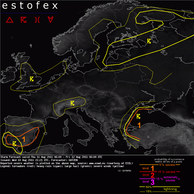
A level 1 was issued for eastern and southern Spain and southern Portugal mainly fro large hail.
(...)
Eastern Spain
Diurnally driven thunderstorms are not ruled out over eastern Spain. Easterly surface winds will advect a moist boundary-layer westward, where upslope flow will provide some low-level forcing. Storm that form will profit from 10-15 m/s bulk shear in the lowest 3 km, supported by north-westerly winds above the boundary layer. Well-organized storms are forecast to produce large hail and strong wind gusts. Convective activity is forecast to spread westward in the evening and night hours, as a cut-off low migrates into southern Portugal and leads to increasing lift. Large hail is expected to be the main severe threat.
Partilhar: