Furacão LORENZO (Atlântico 2019 #AL13)
- Thread starter Afgdr
- Data de início
-
O novo portal está no ar! Novos meteogramas, cartas, e mais. Mais informações neste tópico
Seguimento Meteorológico: Litoral Norte | Interior Norte e Centro | Litoral Centro | Sul | Açores e Madeira | Livre
Previsões: Curto e médio prazo: até 2 semanas | Longo prazo: mensal e sazonal (Regras e links úteis nos 1ºs posts)
Facebook | Avisos IPMA/Alertas ANEPC
You are using an out of date browser. It may not display this or other websites correctly.
You should upgrade or use an alternative browser.
You should upgrade or use an alternative browser.

luismeteo3
Furacão
luismeteo3
Furacão
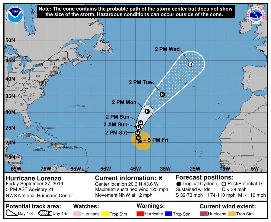
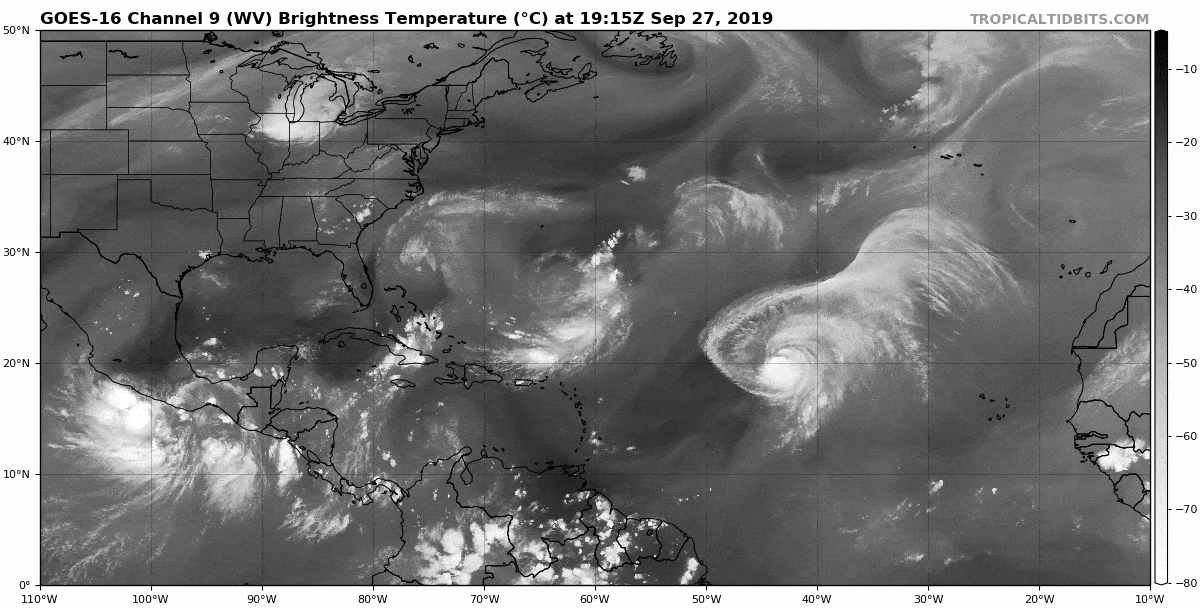
...LORENZO WEAKENS A LITTLE MORE BUT REMAINS VERY LARGE...
5:00 PM AST Fri Sep 27
Location: 20.3°N 43.6°W
Moving: NNW at 12 mph
Min pressure: 948 mb
Max sustained: 125 mph
5:00 PM AST Fri Sep 27
Location: 20.3°N 43.6°W
Moving: NNW at 12 mph
Min pressure: 948 mb
Max sustained: 125 mph
Última edição:
Aviso 21:
Infelizmente não é ainda possível excluir um cat. 2 aquando da passagem pelos Açores. O Lorenzo deverá ter um péssimo aspeto aquando da chegada e a continuamente perder intensidade. Pode é não ser o suficiente para uma passagem (relativamente) tranquila.

---
O outflow já só está a uns 600 quilómetros a sudoeste de Santa Maria.

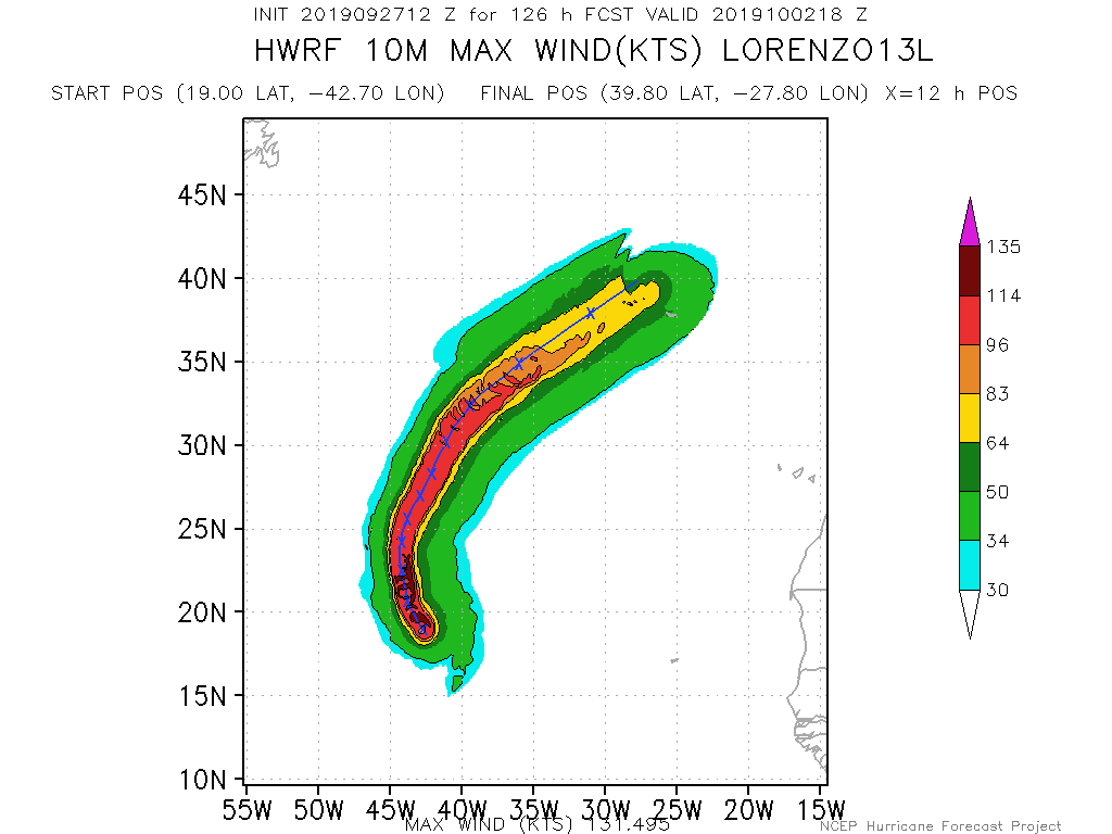
A recent SSMI/S overpass shows that the southern portion of the eyewall has eroded, possibly due to shear or dry air intrusion. The microwave imagery also suggests an outer convective band is forming, but it is not yet well enough defined to call it an outer eyewall. Satellite intensity estimates have continued to decrease, and the initial intensity is lowered to 110 kt as a blend of the various estimates.
Lorenzo will be passing over sea surface temperatures of 27-28C for the next 48-72 h. However, it will be in an environment of moderate vertical shear due to an upper-level trough not far to the west.
The intensity guidance responds to this by showing gradual weakening during this time, and the new intensity forecast follows the trend of the guidance. There is a possibility of fluctuations in intensity caused by eyewall replacement cycles superimposed on this weakening trend. After 72 h, the hurricane should encounter stronger mid-latitude westerlies, move over cooler sea surface temperatures, and eventually merge with the above-mentioned deep-layer trough. As this occurs, Lorenzo is forecast to undergo extratropical transition, with this being complete by 120 h.
Current indications from the global models are that Lorenzo will retain hurricane strength through the transition.
FORECAST POSITIONS AND MAX WINDS
96H 01/1800Z 35.5N 36.0W 90 KT 105 MPH
120H 02/1800Z 44.0N 26.5W 80 KT 90 MPH...POST-TROP/EXTRATROP
Infelizmente não é ainda possível excluir um cat. 2 aquando da passagem pelos Açores. O Lorenzo deverá ter um péssimo aspeto aquando da chegada e a continuamente perder intensidade. Pode é não ser o suficiente para uma passagem (relativamente) tranquila.
---
O outflow já só está a uns 600 quilómetros a sudoeste de Santa Maria.
Dos ensembles dos modelos globais só posso escrever... o Lorenzo ainda guina ligeiramente para leste à última da hora. Grande trampa 
luismeteo3
Furacão
NOAA Plane Headed to Hurricane Lorenzo Diverted for Search and Rescue Mission
Se calhar levou uma sova épica.
Última edição:
Bom dia. Também em Irlanda estámos a seguir Lorenzo, visto que a ex-Ophelia foi semelhante há uns anos. Espero que Lorenzo não seja tão forte como prevista quando chegar nas Açores. Sería a tempestade mais forte na história no arquipelago se for verificar à máxima intensidade?
Enquanto cat. 4? Um bocado difícil mas possivelmente sim. Como escrevi numa outra publicação, não há propriamente grandes arquivos portugueses no que concerne a ciclones tropicais.
Em termos de história, vá, recente, o Lorenzo poderá ser um dos mais fortes 'on record' a afetar os Açores (o Ophelia está num patamar completamente diferente, é uma aberração).
Já abordei o ciclone acima mencionado aqui. É pena que não haja mais e melhor informação.
Finalizo, escrevendo que não há muito tempo o Gordon (2006) foi chamado de 'anomalia'. Não se fazia a mínima ideia do que estava para vir
 :rolleyes:")
Última edição:
algarvio1980
Furacão
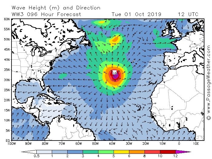
Na saída das 12 do GFS, o Windguru para Horta coloca vento médio de 130 km/h e rajadas de 164km/h, com ondas de 16 metros, o ICON coloca na Horta rajadas de 174 km/h.
Leitura recomendada para meteomalucos  http://www.eumetrain.org/data/4/491/mw2018_thursday_ramalho.pdf
Ricardo Carvalho
Cumulonimbus
Governo Regional prepara as medidas necessárias para enfrentar furacão Lorenzo
https://www.prociv.azores.gov.pt/no...rBec-a0tKL-x5IhMWrBnsTgViCv4Pzoy6elEUbKtxtSqM

Enviado do meu SM-A510F através do Tapatalk
https://www.prociv.azores.gov.pt/no...rBec-a0tKL-x5IhMWrBnsTgViCv4Pzoy6elEUbKtxtSqM

Enviado do meu SM-A510F através do Tapatalk
Ricardo Carvalho
Cumulonimbus
Mais do mesmo  E já bem presente a ligeira rotação do ciclone para NE que os modelos começaram a mostrar no dia de hoje!


 E já bem presente a ligeira rotação do ciclone para NE que os modelos começaram a mostrar no dia de hoje!


luismeteo3
Furacão
luismeteo3
Furacão
"Charneca" Mundial
Super Célula
Com que então, voltaste ao fórum!
")
Bem-vindo de novo.
Desculpem pelo tema fora de tópico.