Previsão e Seguimento de Furacões (Atlântico 2019)

Afgdr

Cumulonimbus
Registo
28 Set 2011
Mensagens
2,130
Local
Lagoa - São Miguel, Açores
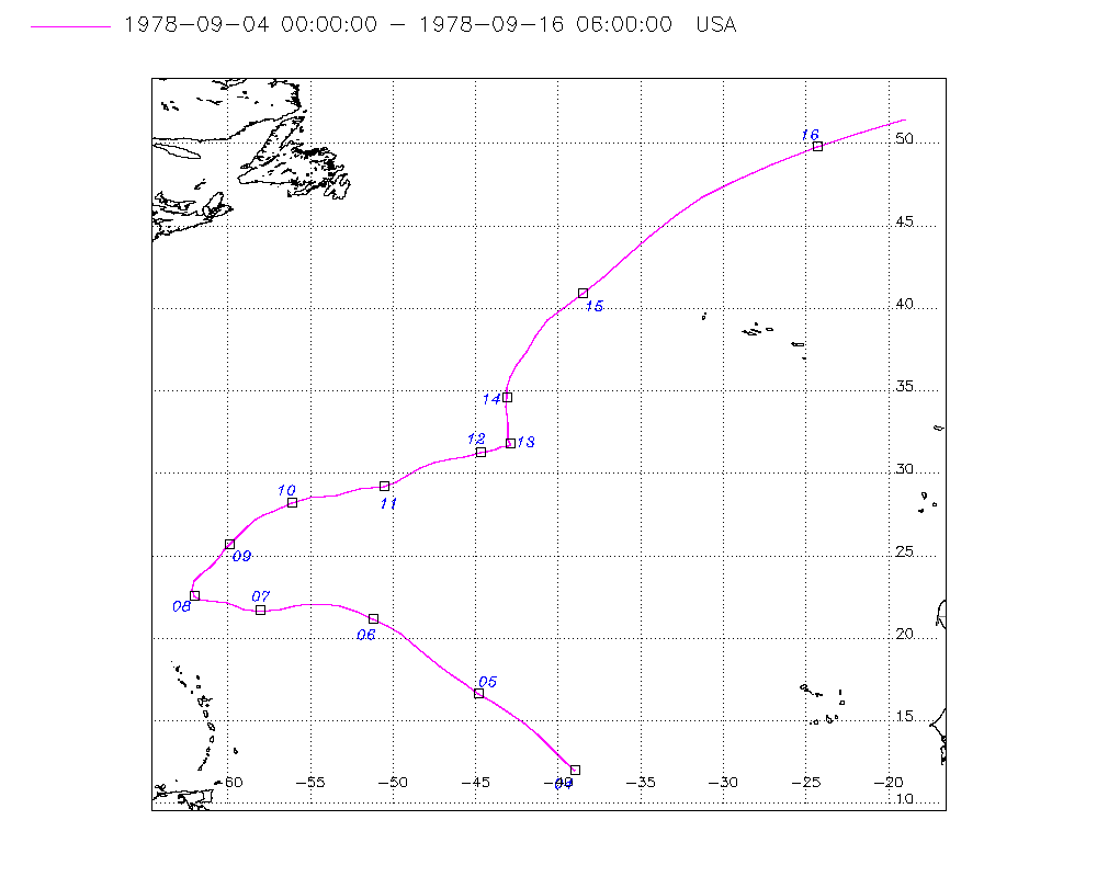
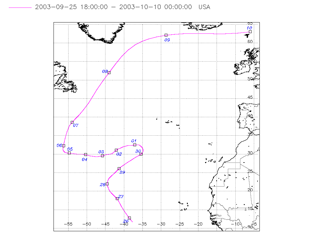
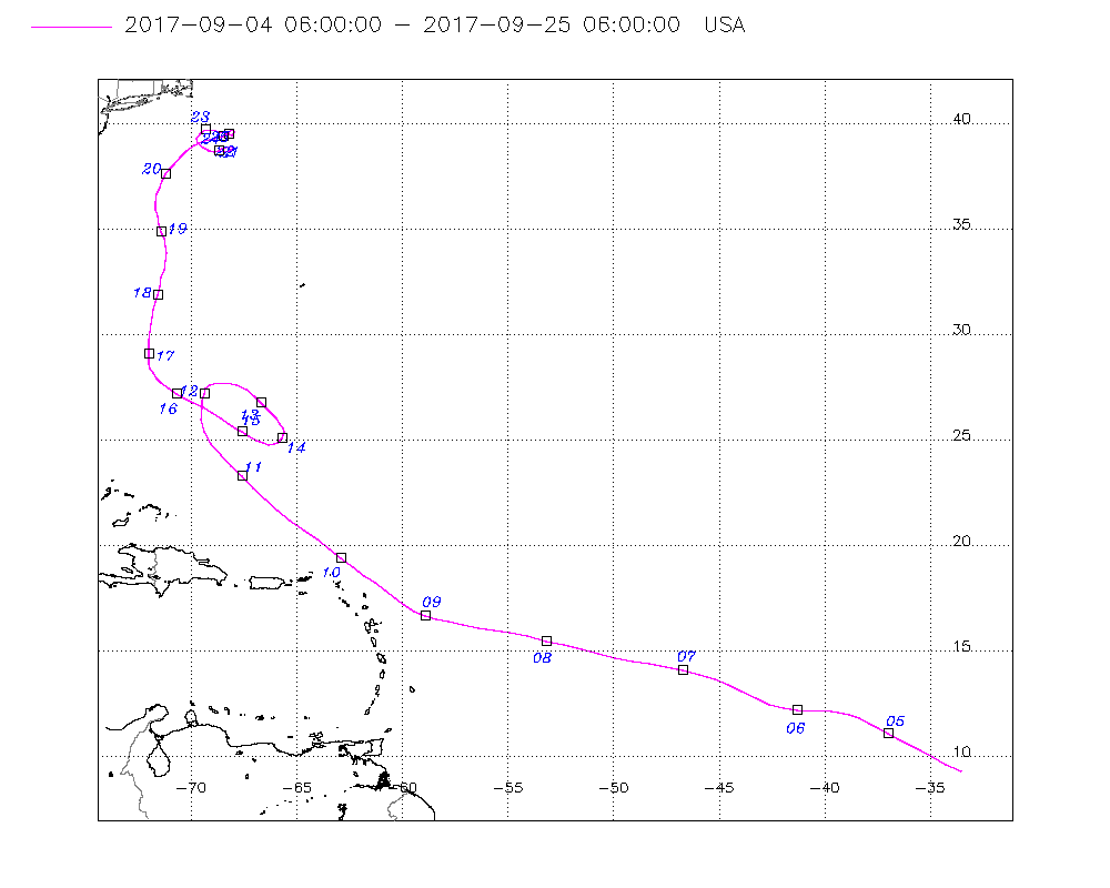
Estão a ser vigiadas 3 áreas no Atlântico, para além da TT Gabrielle.

ABfe8d8.png


Invest 94L - Área a E das Pequenas Antilhas

00h35 UTC

2ReAYAJ.png


Tem 20% de probabilidade de se tornar um ciclone tropical nas próximas 48h / 30% em 120h.


A weak area of low pressure, associated with a tropical wave,
located more than 900 miles east of the Lesser Antilles continues
to produce disorganized showers and thunderstorms. Some slow
development of this system is possible during the next few days
before upper-level winds become unfavorable for tropical cyclone
formation. This system is expected to move generally westward
across the tropical Atlantic Ocean for the next several days.
* Formation chance through 48 hours...low...20 percent.
* Formation chance through 5 days...low...30 percent.


7PjecXB.jpg


Área a N da Ilha Hispaniola

Probabilidade de 0% de formação de ciclone tropical em 48h / 20% em 120h

A surface trough interacting with an upper-level low is producing
disorganized showers and thunderstorms from the north coast of
Hispaniola northward over the southwestern Atlantic for a few
hundred miles. Little, if any, development of this disturbance is
expected during the next few days while it moves west-northwestward
across the Bahamas and the Florida peninsula. However, environmental
conditions could become a little more conducive for development
when the system moves into the Gulf of Mexico over the weekend.
Regardless of development, this disturbance will produce periods of
gusty winds and locally heavy rainfall across the Bahamas through
Thursday, and across Florida on Friday and continuing into the
weekend.
* Formation chance through 48 hours...low...near 0 percent.
* Formation chance through 5 days...low...20 percent.


bfjmBab.jpg


Área a W de África

Probabilidade de 0% de formação de ciclone tropical em 48h / 20% em 120h

3. A tropical wave located just off the west coast of Africa is
expected to move quickly westward during the next several days.
Some slow development is possible late this week and over the
weekend when the system is several hundred miles east of the
Lesser Antilles.
* Formation chance through 48 hours...low...near 0 percent.
* Formation chance through 5 days...low...20 percent.

q3LL8XA.jpg


Orion

Furacão
Registo
5 Jul 2011
Mensagens
21,648
Local
Açores
tws_atl_latest.gif


Tropical cyclone activity during August was near average for the Atlantic basin, with three named storms forming during the month and one of them, Dorian, becoming a major hurricane. Based on a 30-year climatology (1981-2010), three named storms typically form in the basin in August, with one or two of them becoming hurricanes, and one of them becoming a major hurricane.

In terms of Accumulated Cyclone Energy (ACE), which measures the combined strength and duration of tropical storms and hurricanes, activity in the Atlantic basin so far in 2019 is near normal.
 

Afgdr

Cumulonimbus
Registo
28 Set 2011
Mensagens
2,130
Local
Lagoa - São Miguel, Açores
Hoje, dia 10 de setembro, é o pico climatológico da época de furacões.


ifnXZ4I.gif


This week is the statistical peak of the Atlantic hurricane season: When the Atlantic has had the most hurricanes and named storms over the course of history.

But this seasonal peak isn't simply useless statistics. It illustrates that this is the time of year when conditions are most optimal for the development of tropical storms and hurricanes.

There's an overlap of favorable factors in early-mid September, including ocean water reaching its highest temperature, the atmosphere's ability to generate thunderstorms hitting its peak, hostile shearing winds declining to a minimum and a parade of disturbances known as tropical waves acting as seeds for development that, while peaking in July, are numerous in September.

Fonte: The Weather Channel (link)


Este é um gráfico interessante, que relaciona as SSTs e o Windshear observados ao longo dos meses do ano e a nomeação dos sistemas tropicais.


Relação SSTs e Wind Shear & Sistemas Tropicais Nomeados

jrXFfR9.jpg


Fonte: Michael Lowry via Twitter (link do tweet)
 

Afgdr

Cumulonimbus
Registo
28 Set 2011
Mensagens
2,130
Local
Lagoa - São Miguel, Açores
Duas áreas no Atlântico estão a ser observadas pelo NHC.

n6XKFbL.png


Invest 95L (perto das Bahamas centrais e do SE)

Tem 70% probabilidade de evoluir para depressão tropical/tempestade tropical nas próximas 48h / 80% nas próximas 120h.

1. Satellite images indicate that the area of disturbed weather over
the central and southeastern Bahamas is gradually becoming better
organized while surface pressures are falling in the area.
Conditions are becoming favorable for a tropical depression or a
tropical storm to form within the next day or so as the system moves
toward the northwest through the northwestern Bahamas and toward
the Florida Peninsula at 5 to 10 mph. If this development trend
continues Potential Tropical Cyclone advisories will likely be
initiated later today. This disturbance will bring heavy rainfall
and gusty winds across portions of the Bahamas through Friday,
especially in portions of the northwestern Bahamas affected by
Hurricane Dorian. An Air Force Reserve reconnaissance aircraft is
scheduled to investigate the system this afternoon, if necessary.
* Formation chance through 48 hours...high...70 percent.
* Formation chance through 5 days...high...80 percent.

15h25 UTC

E5EaeDT.png


As Bahamas e o estado da Flórida, recentemente afetados pelo Dorian, estão na área de trajetória possível deste futuro sistema tropical.

26v6045.jpg


Onda tropical a W de Cabo Verde

Tem 0% probabilidade de evoluir para ciclone tropical nas próximas 48h / 40% nas próximas 120h.

2. A tropical wave located several hundred miles west of the Cabo
Verde Islands is producing disorganized showers and thunderstorms.
Conditions appear conducive for development, and a tropical
depression could form early next week while the system moves
westward over the tropical Atlantic.
* Formation chance through 48 hours...low...near 0 percent.
* Formation chance through 5 days...medium...40 percent.

15h25 UTC

OFcYpXu.png
 

Afgdr

Cumulonimbus
Registo
28 Set 2011
Mensagens
2,130
Local
Lagoa - São Miguel, Açores
O Invest 95L está agora classificado como "Potencial Ciclone Tropical Nove". Deverá formar-se um ciclone tropical em 1/2 dias.

Apresenta uma probabilidade elevada (70% / 80%) de evoluir para ciclone tropical nas próximas 48h e 120h, respetivamente.

Situação atual:
Movimento: NW a 8 mph (13 km/h)
Intensidade: 30 mph (48 km/h)
Pressão mínima central: 1008 hPa


23h10 UTC

Yv0T7XI.jpg


AvZwDbM.jpg


A rota prevista pelo NHC aponta para a passagem deste sistema pelas Bahamas de NW e pela Costa Leste da Flórida.

9wa26W8.png


Por enquanto, não se prevê um desenvolvimento muito significativo deste sistema, esperando-se um pico de intensidade de 50 mph (80 km/h) no dia 14.

FORECAST POSITIONS AND MAX WINDS
INIT 12/2100Z 23.7N 74.8W 25 KT 30 MPH...POTENTIAL TROP CYCLONE
12H 13/0600Z 24.5N 76.0W 25 KT 30 MPH
24H 13/1800Z 25.5N 77.2W 30 KT 35 MPH...TROPICAL CYCLONE
36H 14/0600Z 26.5N 78.9W 40 KT 45 MPH
48H 14/1800Z 27.5N 80.2W 45 KT 50 MPH
72H 15/1800Z 30.0N 82.0W 30 KT 35 MPH...INLAND
96H 16/1800Z 31.0N 82.0W 25 KT 30 MPH...INLAND
120H 17/1800Z 31.5N 80.0W 30 KT 35 MPH...OVER WATER


Foi ativado um aviso de tempestade tropical para as Bahamas de Noroeste, exceto para a Ilha de Andros, ilhas recentemente fustigadas pelo Furacão Dorian.

chn7kGX.jpg
 
  • Gosto
Reactions: Wessel1985

Afgdr

Cumulonimbus
Registo
28 Set 2011
Mensagens
2,130
Local
Lagoa - São Miguel, Açores
O PCT9 está estacionário com a mesma intensidade - 30 mph.

Brevemente, deverá formar-se um ciclone tropical. Aumentou para 80% / 90% a probabilidade de o sistema se tornar um ciclone tropical nas próximas 48h / 120h, respetivamente.


Vários modelos apontam para um landfall da perturbação nalgumas ilhas das Bahamas e/ou na Costa Leste da Flórida.

Run das 00z


z5jMtH5.png


Quase todos os modelos colocam a perturbação a atingir a categoria de tempestade tropical. Apenas 1 coloca o sistema a chegar à categoria de furacão.

Run das 00z


v4vK9NT.png
 
  • Gosto
Reactions: Wessel1985

Afgdr

Cumulonimbus
Registo
28 Set 2011
Mensagens
2,130
Local
Lagoa - São Miguel, Açores
Neste momento, a situação no Atlântico é esta: 1 depressão tropical (DT 9) e outras 3 áreas com potencial para se tornarem ciclones tropicais.

KC7vvDW.png


Onda tropical a E das Pequenas Antilhas (Invest 96L): probabilidade baixa de formação de ciclone tropical nas próximas 48h/120h (10% / 30%, respetivamente)

1. A fast-moving tropical wave is located about 1100 miles east of the
Lesser Antilles. This system is producing limited shower activity
and only gradual development is anticipated during the next couple
of days while the wave moves quickly westward across the tropical
Atlantic. Conditions could be a little more conducive for
development in a few days when the wave moves over the eastern
Caribbean Sea.
* Formation chance through 48 hours...low...10 percent.
* Formation chance through 5 days...low...30 percent.


01h25 UTC

Lec54qG.png


Onda tropical a SW de Cabo Verde: probabilidade baixa de formação de ciclone tropical nas próximas 48h (10%); média nas próximas 120h (50%)

2. Another tropical wave is located about 600 miles southwest of the
Cabo Verde Islands. Gradual development of this system is possible
during the next several days, and a tropical depression
could form early next week while it moves westward across the
tropical Atlantic.
* Formation chance through 48 hours...low...10 percent.
* Formation chance through 5 days...medium...50 percent.


01h25 UTC

tSLkD4g.png


Área a WSW de Cabo Verde, entre as duas ondas tropicais: probabilidade baixa de formação de ciclone tropical nas próximas 48h/120h (10% / 20%, respetivamente)

3. An area of disturbed weather has developed between two tropical
waves, about 1000 miles west-southwest of the Cabo Verde Islands.
This disturbance may merge with a tropical wave approaching from
the east over the weekend. However, some development of this system
is possible through early next week as long as it remains distinct
from the wave. The disturbance is forecast to move slowly westward.
* Formation chance through 48 hours...low...10 percent.
* Formation chance through 5 days...low...20 percent.


01h25 UTC

Wz4YNNc.png
 

Afgdr

Cumulonimbus
Registo
28 Set 2011
Mensagens
2,130
Local
Lagoa - São Miguel, Açores
Estão sob observação 2 áreas, para além do Humberto.

9E1Pj5v.png


Invest 97L:
-
probabilidade baixa (30%) de evoluir para ciclone tropical nas próximas 48h; elevada (80%) nas próximas 120h


1. A small low pressure system is producing an area of disorganized
showers and thunderstorms over the east-central tropical
Atlantic. Slow development is possible during the next day or
two, but environmental conditions are forecast to become more
conducive for development by the middle of the week, and a tropical
depression is likely to form by the end of the week while the system
moves slowly west-northwestward to northwestward.
* Formation chance through 48 hours...low...30 percent.
* Formation chance through 5 days...high...80 percent.

PzjAwmT.jpg


01h25 UTC

QYGf3ct.png


Área no Golfo do México:
-
probabilidade baixa (10%) de evoluir para ciclone tropical nas próximas 48-120h


2. A broad area of disorganized showers and thunderstorms over the
central and eastern Gulf of Mexico is associated with an upper-level
low and a weak surface trough. Some slight development of this
system is possible during the next couple of days while it moves
westward over the western Gulf of Mexico. The system is forecast to
move inland along the northwestern Gulf coast by late Monday or
Tuesday, and further development is not expected after that time.
* Formation chance through 48 hours...low...10 percent.
* Formation chance through 5 days...low...10 percent.

7yuGfyE.jpg


01h25 UTC

lb3Uzaf.png
 

Afgdr

Cumulonimbus
Registo
28 Set 2011
Mensagens
2,130
Local
Lagoa - São Miguel, Açores
2 Invest no Atlântico neste momento: 97L e 98L.

UR3CYmX.png


Invest 97L

Probabilidade elevada (90%) de formação de ciclone tropical nas próximas 48h-120h

1. A small low pressure system is located about 1000 miles east of the
Lesser Antilles. The associated shower and thunderstorm activity has
increased and become a little better organized this morning, and
conditions are expected to be conducive for the formation of a
tropical depression during the next day or so while the system moves
slowly northwestward to west-northwestward.
* Formation chance through 48 hours...high...90 percent.
* Formation chance through 5 days...high...90 percent.


14h15 UTC
9flbXff.png


Invest 98L

Probabilidade baixa (30%) de formação de ciclone tropical nas próximas 48h-120h

2. Shower activity associated with a broad area of low pressure located
over the northwestern Gulf of Mexico near the central Texas coast
has changed little in organization. However, some slight development
is still possible before the system moves inland along the
northwestern Gulf coast later tonight or early Wednesday. Regardless
of development, this disturbance is expected to produce areas of
very heavy rainfall and possible flash flooding along the coastal
regions of southwestern Louisiana and central and upper Texas
tonight and Wednesday, and over eastern Texas and western Louisiana
on Thursday. For additional information, see products issued by your
local weather forecast office and the Weather Prediction Center.
* Formation chance through 48 hours...low...30 percent.
* Formation chance through 5 days...low...30 percent.


14h15 UTC
r8j61Kl.png