"028
WTNT42 KNHC 221455
TCDAT2
Visible satellite imagery shows that Gabrielle is an impressive,
well-organized hurricane. The eye of Gabrielle has recently
warmed, though the eyewall convection remains a bit fractured in
the northeastern quadrant. Bermuda radar also has the suggestion
of the beginning of an eyewall replacement cycle, with an outer
eyewall possibly forming. The initial intensity is held at 105 kt,
at the top end of the various intensity estimates, and a NOAA
Hurricane Hunter will be in the area during the next few hours
for a closer look at the hurricane.
Gabrielle is moving northward at about 9 kt. The track forecast
seems straightforward with the subtropical ridge providing the
steering for the next several days. The hurricane should turn
northeastward tonight and then move faster to the east-northeast
during the next few days due to Gabrielle encountering stronger
mid-latitude flow. Model guidance is generally a bit faster than
the last cycle, and the new forecast is adjusted in that direction.
Extratropical transition is expected on Friday while the system is
in the vicinity of the Azores.
The hurricane is moving over very warm waters within moderate shear
today, so further intensification is expected. A combination of
cooler waters and increasing shear should cause Gabrielle to start
to weaken tomorrow. While SSTs drop off more significantly by
midweek, an upper-level trough could provide a favorable trough
interaction, keeping the hurricane more organized than other
environmental conditions might suggest. The new NHC intensity
forecast is similar to the previous one, showing a gradual
weakening during most of the forecast and lies close to the model
consensus.
KEY MESSAGES:
1. Gusty winds and showers will be possible across Bermuda today
and tonight as Hurricane Gabrielle passes by to the east.
2. Swells generated by Gabrielle will continue to affect Bermuda
during the next few days. These swells are now reaching the east
coast of the United States from North Carolina northward, as well as
Atlantic Canada, and should continue during the next couple of days.
These swells are likely to cause life-threatening surf and rip
current conditions. Please consult products from your local weather
office.
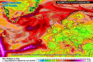
3. Gabrielle is forecast to approach the Azores on Thursday.
Interests in the Azores should monitor the progress of Gabrielle
though it is too soon to specify the magnitude of potential
wind, rainfall, and wave impacts.
Forecaster Blake"


 Enfraquecimento (temporário?) mas expansão do campo de ventos.
