Previsão e Seguimento de Furacões (Atlântico 2025)

  • Thread starter Thread starter Orion
  • Data de início Data de início
Há uma hipótese baixa (10%) de formação de uma depressão subtropical nos próximos dias, na latitude dos Açores:
280854_5day_cone_no_line_and_wind.webp


Imagem de satélite EUMETSAT, que mostra um núcleo frio bem definido perto dos EUA:
Eumetsat.webp


No Atlântico norte temos visível a depressão que arrastará uma frente para a Península Ibérica, embebida em ar húmido tropical.
 
Última edição:
A previsão (total) é lixo e os modelos geralmente não são grande coisa a prever os invests. Ainda assim, e tendo em conta a altura, há possibilidade para o aparecimento de algo relevante.
image0.jpg


Este ano parece que existe uma parede invisível que obriga todas as tempestades a dar curva de 180 graus. Nenhuma entra pelos Estados Unidos a dentro.
 
O colosso do ano.

gMulzpO.gif


A previsão (total) é lixo e os modelos geralmente não são grande coisa a prever os invests. Ainda assim, e tendo em conta a altura, há possibilidade para o aparecimento de algo relevante.

ships.png
Veja a análise completa aqui
Exatamente! Isso é o mais agradável. Já estou cansado do calor sufocante do verão, mas essa frescura matinal é simplesmente maravilhosa! Espero que essa tendência de noites mais frescas continue.
 
  • Gosto
Reactions: "Charneca" Mundial
Tempestade Tropical Melissa tem previsão de ser furacão ao aproximar-se lentamente da Jamaica, mas o cone de incerteza é enorme a esta escala, quer em direcção quer em velocidade do movimento.

NHC hoje às 3:00 utc.
Melissa-track_adv03.webp


Ontem às 21:00 a previsão do potencial de precipitação acumulada dirigia-se mais para o flanco direito da trajectória então prevista, a qual tem vindo a derivar para Oeste.
Melissa-Prec_adv02.webp


Apesar da aparente desorganização, Melissa já é tempestade tropical, mas com rumo quase errático e difícil de definir:

 
Última edição:
Melissa já deverá ter uma intensificação bem mais rápida do que o esperado. :intrigante:

Esta é a imagem satélite de Infravermelhos actual:
1808x1808.webp


Esta é a imagem sátelite de Massas de Ar actual:
Eumetsat2.webp


Esperemos pela análise do NHC...
 
GOES19-CAR-GEOCOLOR-1000x1000.gif

O seu tamanho cresceu de forma notória...
 
O seu tamanho cresceu de forma notória...
Um out-flow notável em quase todos os quadrantes!

Mas... 'shear'
000
WTNT43 KNHC 221455
TCDAT3

Tropical Storm Melissa Discussion Number 5
NWS National Hurricane Center Miami FL AL132025
1100 AM EDT Wed Oct 22 2025

While Melissa continues to produce bursting convection on satellite
imagery, with very cold cloud tops down to -95C, there is little
evidence these convective bands are wrapping around the center.
West-northwesterly shear of 20 to 25 kt is currently preventing the
low-level and mid-level circulation centers from aligning. This
downshear tilt with height has also been observed by the latest Air
Force Reconnaissance mission, which reported significant winds at
the surface in their most recent 850 mb center drop. The initial
intensity for this advisory is held at 45 kt, taking a blend of
recon observations which had a peak wind of 52 kt at 850 mb, and
satellite intensity estimates from TAFB, ADT, and D-MINT. The wind
field of Melissa also remains very asymmetric, as evidence of a
recent 1040z RCM-1 Synthetic Aperture Radar pass showing the bulk of
tropical-storm-force winds east of the center.

The tropical storm has slowed down to a crawl this morning, with the
estimated motion at 300/2 kt. The track forecast remains challenging
today, and strongly related to the storm's structure in the
short-term.
For the next 12-24 hours, Melissa is forecast to move
very slowly to the northwest as it attempts to move into a weakness
produced by an broad upper-level trough centered over the Bahamas.
Whether or not it turns more rightward into this weakness is related
to the vertical depth the various model guidance is depicting. The
06z GFS run, which is the model that has been on the right side of
the guidance envelope for days, shows a more vertically coherent
system over the next 24-48 hours, and causes Melissa to abruptly
turn northeastward over the next 48 hours. While this appears to be
an outlier solution, the Google DeepMind ensemble mean (GDMI) also
shows this northeastward motion, and a significant fraction of its
ensemble members show the Melissa making landfall on the Island of
Hispaniola. However, the remainder of the track guidance, including
the ECMWF and its ensemble mean, suggest that Melissa will remain
misaligned and move more slowly north-northwest over the next couple
of days. The NHC track solution slightly favors the latter
scenarios, lying just east of the ECMWF mean, out of respect of the
reliable GDMI aid. After about 60 h, mid-level ridging begins to
build back in to the north, and most of the guidance responds by
showing a sharp turn westward, albeit still at a snail's pace. The
overall track guidance, GFS and GDMI excluded, has shifted left this
cycle beyond 72 h, and the NHC track was shifted in that direction,
but not as far south and west as the HAFS-A/B regional models. It
goes without saying, this is a very challenging track forecast.

The intensity forecast has its own share of challenges. At least in
the short-term, vertical wind shear is expected to persist between
20 to 30 kt, and will likely prevent Melissa from becoming fully
aligned and taking advantage over the very warm 30-31C sea surface
temperatures. After about 48 hours, the GFS and ECMWF-based SHIPS
guidance shows the shear decreasing gradually, but the timing on
when the system becomes more vertically coherent varies among both
the global and hurricane-regional model guidance. Most of the
guidance shows significant or even rapid intensification in days
3-5, and the NHC intensity forecast was raised once again during
this time frame, but not as high as the HCCA or hurricane-regional
models due to continuity constraints to the previous forecast. The
day 5 forecast now shows Melissa becoming a major hurricane, and
further upward adjustments may be necessary in subsequent cycles.
The intensity forecast is also more uncertain than usual, in large
part related to the track uncertainty.

Key Messages:

1. Melissa is expected to produce heavy rainfall across portions of
the Dominican Republic, Haiti, and Jamaica through this weekend,
bringing a risk of significant flash flooding and landslides.

2. Hurricane conditions are possible in the southwestern peninsula
of Haiti where a Hurricane Watch is in effect. A Tropical Storm
Watch is in effect for Jamaica. Preparations to protect life and
property should be completed by Thursday.

3. There is significant uncertainty in the track and intensity
forecast of Melissa. Interests elsewhere in Hispaniola and Cuba
should continue to monitor the latest forecasts.


FORECAST POSITIONS AND MAX WINDS

INIT 22/1500Z 14.4N 73.6W 45 KT 50 MPH
12H 23/0000Z 14.8N 73.9W 45 KT 50 MPH
24H 23/1200Z 15.2N 74.3W 50 KT 60 MPH
36H 24/0000Z 15.6N 74.4W 55 KT 65 MPH
48H 24/1200Z 16.0N 74.4W 55 KT 65 MPH
60H 25/0000Z 16.3N 74.6W 60 KT 70 MPH
72H 25/1200Z 16.5N 74.9W 70 KT 80 MPH
96H 26/1200Z 16.6N 75.8W 90 KT 105 MPH
120H 27/1200Z 16.4N 77.4W 105 KT 120 MPH


$$
Forecaster Papin

Major Hurricane a cerca de 100 milhas da costa sul da Jamaica, não será fácil para esta ilha.
Melissa-track_adv05.webp


Vai ser localmente muito pior...

232050INTQPF_sm.gif

... tendo em conta a orografia das ilhas (inclui Haiti):

detailed-elevation-map-of-jamaica.jpg


Cuba continua numa situação energética miserável. O último furacão que atravessou o leste montanhoso foi em 2016 (em 2017 passou um ligeiramente a norte).

grand_ensemble_density_lines.png


atl_season_2016_sm.png
 
Última edição:
Melissa pode vir a ser Categoria 4 durante pelo menos 48 horas, aproximando-se da costa SW/W da Jamaica mas os ventos máximos podem atingir toda a costa sul. Landfall não está excluído, e será catastrófico se acontecer com esta intensidade.

Previsão do NHC às 00:00 utc de hoje dia 24
HKTf5pT.png


000
WTNT43 KNHC 232059
TCDAT3

Tropical Storm Melissa Discussion Number 10
NWS National Hurricane Center Miami FL AL132025
500 PM EDT Thu Oct 23 2025

Like the past couple of days, Melissa's structure has degraded once
again this afternoon, with the low-level circulation yet again
becoming partially exposed on the west side of the deepest
convection. This structure is consistent with a tropical cyclone
that continues to exhibit significant tilt with height in the
downshear direction. A scatterometer pass received after the prior
advisory also indicated the center itself remains quite broad with a
continued asymmetric wind field and large radius of maximum wind.
The initial intensity is being held at 40 kt this advisory, without
a substantial change in the subjective or objective intensity aids
since the last recon plane left the storm. A NOAA-P3 recon mission
will sample the system this evening providing updated detail on
the structure and intensity of the storm.

Melissa continues to move very slowly, with the initial motion a
very slow north-northwest drift at 345/2 kt. The tropical storm's
very slow motion over the last day or so is related to it being
caught between two mid-level ridges, one located to its southeast
over the Lesser Antilles providing northeast steering, and another
mid-level ridge building in northwest from Mexico providing
southwest steering. Their combined influence is roughly canceling
Melissa's overall steering, with a lot of track influences the last
couple of nights related to center reformations to the east and
north. Interestingly, much of the hurricane-regional model guidance
suggests another reformation could occur tonight, and the track
guidance envelope has a distinct bend to the northeast in the 12 to
24 hour forecast points. Given the large convective burst ongoing
just east of the current broad center, it is feasible it may nudge
the short-term track east of due north. After the next day or so,
the mid-level ridge currently over Mexico is expected to expand
poleward of the storm, and is expected to help turn Melissa to the
west. How far north Melissa gets before it turns to the west
continues to remain uncertain. One notable change from this morning
is that the 12z Google DeepMind ensemble mean (GDMI), which was
previously on the northeast side of the track guidance, abruptly
shifted to the southwest side of the envelope, now very close to
the latest 12z ECWMF forecast. In contrast, both the 12z HAFS-A/B
regional hurricane models shifted their tracks further north and
east, related to an overnight center reformation. All these
shuffling guidance tracks highlight the uncertainty of the overall
track forecast, and the latest NHC track was only nudged slightly
southward from this morning, blending the reliable HCCA and GDMI
aids. This forecast track takes Melissa just south of Jamaica in
60-96 hours, though it is worth noting there are guidance aids that
move it near or over Jamaica earlier in the forecast than shown
here.

Melissa's broad and asymmetric structure argues against much
short-term intensification, though the shear that had been plaguing
the system is soon expected to decrease. It will likely take at
least 24 hours for the storm's tilted structure to become better
aligned to take advantage of the other favorable environmental
factors (very warm sea-surface temperatures, sufficently moist
mid-levels). Regardless, the intensity guidance is insistent on
Melissa undergoing a period of rapid intensification in the forecast
period, and all 50 members of the Google DeepMind ensemble show the
system becoming a major hurricane or stronger. The NHC intensity
forecast will follow suit, showing rapid intensification from 36 to
72 h, intensifying Melissa from a tropical storm to a category 4
hurricane in this time period. Remarkably, this is still lower than
some of the hurricane-regional models, and is in best agreement
with the GDMI intensity forecast, which have plenty of members
stronger this the current NHC peak intensity of 125 kt. Over the
forecast period, the tropical cyclone is expected to grow in size
significantly, and it will likely be a large and dangerous hurricane
towards the end of the forecast period.


Key Messages:

1. Jamaica: Due to Melissa’s slow motion, the risk of a prolonged
multi-day period of potentially damaging winds, heavy rainfall
resulting in life-threatening flash flooding and numerous
landslides, and storm surge continues to increase for Jamaica.
Preparations to protect life and property should be rushed to
completion, since strong winds and flooding rains could begin in
Jamaica by Friday or Saturday.

2. Haiti: Heavy rainfall will result in catastrophic flash
flooding and landslides across southwestern Haiti by this weekend
into early next week. Extensive damage to roads and buildings is
expected, potentially isolating communities for an extended period
of time. This is a life-threatening situation and immediate
preparations to protect life and property should be taken. Strong
winds could also potentially last for a day or more over the Tiburon
peninsula of Haiti.

3. Remainder of Hispaniola and Eastern Cuba: Heavy rainfall could
also produce significant, life-threatening flash flooding and
numerous landslides in southern Dominican Republic. Interests in
Cuba should monitor the progress of Melissa since the risk of heavy
rainfall, damaging winds, and storm surge appears to be increasing.


FORECAST POSITIONS AND MAX WINDS

INIT 23/2100Z 15.6N 75.5W 40 KT 45 MPH
12H 24/0600Z 15.8N 75.2W 45 KT 50 MPH
24H 24/1800Z 16.0N 75.0W 50 KT 60 MPH
36H 25/0600Z 16.5N 75.1W 60 KT 70 MPH
48H 25/1800Z 16.8N 75.4W 80 KT 90 MPH
60H 26/0600Z 17.1N 76.0W 100 KT 115 MPH
72H 26/1800Z 17.1N 76.7W 115 KT 130 MPH
96H 27/1800Z 17.1N 77.8W 125 KT 145 MPH
120H 28/1800Z 18.0N 78.4W 125 KT 145 MPH

$$
Forecaster Papin

A zona extrema Leste da Jamaica já tem previsão de acumulados entre 200 e 300 mm, enquanto a costa sul da ilha de Hispaniola pode até chegar a mais de 300mm, sobretudo do lado oeste, Haiti.
232333INTQPF_sm.gif


A definição e seguimento do centro e movimento geral não é fácil, a organização ainda é... caótica, mas se toda aquela convecção começar a organizar-se em rotação em torno de um centro então, como está previsto, o salto de intensidade dos ventos será muito rápido.

Melissa, 40 horas até dia 24 às 2.00 utc

 
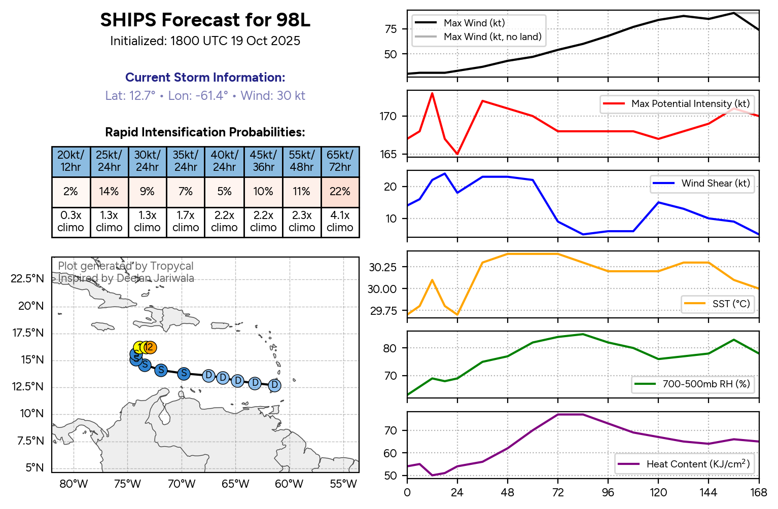
Melissa, ciclone tropical potencialmente catastrófico para a Jamaica, previsão de Categoria 4 superior com landfall e a maior parte da ilha nos quadrantes do lado direito do centro em relação à direcção do movimento. Pode ser o pior ataque de sempre de um furacão à Jamaica.

Aviso 13, às 15:00utc
Melissa-track_adv13.webp


241630INTQPF_sm.gif


O movimento lento para Oeste e depois Noroeste, antes da curva para N/NNE preparatória do landfall, com o flanco direito a atingir a Jamaica durante a aproximação antes da viragem são as condições mais gravosas para acumulados de precipitação superiores a 300 mm e perspectiva de aumentarem acima dos 400mm.

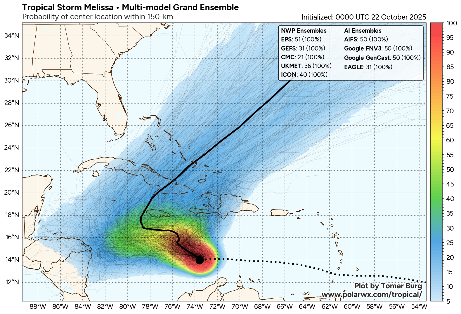
Actualização às 16:30 utc:

"000
WTNT63 KNHC 241630
TCUAT3

Tropical Storm Melissa Tropical Cyclone Update
NWS National Hurricane Center Miami FL AL132025
1230 PM EDT Fri Oct 24 2025

...AIRCRAFT DATA INDICATES THAT MELISSA IS STRENGTHENING...

Air Force Reserve reconnaissance aircraft data indicates that
Melissa is strengthening, and maximum sustained winds are now
estimated to be 60 mph (95 km/h) with higher gusts. The minimum
pressure from aircraft dropsonde data has dropped to 999 mb
(29.50 inches).

SUMMARY OF 1230 PM EDT...1630 UTC...INFORMATION
---------------------------------------------------
LOCATION...15.6N 74.5W
ABOUT 220 MI...355 KM SE OF KINGSTON JAMAICA
ABOUT 250 MI...405 KM SW OF PORT AU PRINCE HAITI
MAXIMUM SUSTAINED WINDS...60 MPH...95 KM/H
PRESENT MOVEMENT...ESE OR 105 DEGREES AT 2 MPH...4 KM/H
MINIMUM CENTRAL PRESSURE...999 MB...29.50 INCHES

$$
Forecaster Papin

FORECAST POSITIONS AND MAX WINDS

INIT 24/1500Z 15.7N 74.6W 40 KT 45 MPH
12H 25/0000Z 15.9N 74.5W 45 KT 50 MPH
24H 25/1200Z 16.3N 74.6W 60 KT 70 MPH
36H 26/0000Z 16.5N 75.3W 70 KT 80 MPH
48H 26/1200Z 16.6N 76.0W 85 KT 100 MPH
60H 27/0000Z 16.6N 76.8W 105 KT 120 MPH
72H 27/1200Z 16.6N 77.5W 125 KT 145 MPH
96H 28/1200Z 17.5N 78.3W 130 KT 150 MPH

120H 29/1200Z 20.4N 76.7W 105 KT 120 MPH...INLAND
 
Com o novo Aviso 14, às 21:00 utc, a previsão subiu a intensidade dos ventos e os valores dos prováveis acumulados de precipitação. Em resumo, quase se poderá dizer que são o pior possível. Único aspecto menos mau é o deslocamento para Leste da trajectória na altura do atravessamento do centro pela ilha da Jamaica (área afectada na ilha pelos ventos máximos e precipitação catastróficos seria assim diminuída). Melissa tem previsão de poder atingir a categoria 5, máxima na escala, com ventos máximos sustentados superiores aos 135 nós previstos (categoria 4 no limite superior).

000
WTNT43 KNHC 242054
TCDAT3

Tropical Storm Melissa Discussion Number 14
NWS National Hurricane Center Miami FL AL132025
500 PM EDT Fri Oct 24 2025

After the previous advisory, the last couple of aircraft fixes from
the C-130 indicated that Melissa likely completed a center
relocation as a very large burst of deep convection with cloud tops
below -90C rotated up-shear of the center. This evolution was also
nicely captured on the GOES-19 mesoscale sector, where GLM lightning
flashes, which had been parked down-shear earlier in the morning,
started to rotate cyclonically along Melissa's eastern flank,
indicating convection was finally starting to wrap around the
low-level vortex. A GMI microwave pass at 1527 UTC also hinted at a
nascent inner core feature on the 37 GHz channel as the convective
burst wrapped around the center. Before the Air Force Hurricane
Hunters left Melissa, they measured a peak flight level wind of 59
kt, and a pressure down to 997 mb, supporting the 50 kt intensity
for the intermediate advisory. However, given the improvement of
Melissa's structure since that time, the initial intensity is being
raised to 55 kt for this advisory, in best agreement with the
T3.5/55-kt Dvorak intensity estimate provided by TAFB. Another Air
Force Reserve and a NOAA-P3 reconnaissance mission will be in the
storm tonight to provide more data on Melissa's intensity and
structure.

Now that the center is becoming better aligned with its mid-level
vortex, it also appears the tropical storm has finally turned more
northward, with an estimated motion of 360/2 kt. The synoptic track
reasoning remains similar to this morning, with a slow motion
expected to continue in the short-term due light steering currents,
due to competing mid-level ridges to the southeast and northwest of
Melissa. After 24 hours, the mid-level ridge located to the
northwest is expected to strengthen to the north of Melissa, and the
guidance is coming into better agreement on a very slow westward
motion through 72 hours. Beyond that time frame, a strengthening
mid-latitude trough expected to move into the Southeastern U.S.,
providing a path for Melissa to turn northeastward out of the
Caribbean Sea into the southwestern Atlantic by the end of the
forecast period. The track guidance this cycle has shifted a bit
eastward beyond day 3, and is also notably faster than before.
However, it should be stressed that there remains a substantial
amount of along track spread. On the forecast track, Melissa could
potentially be near Jamaica by day 4 and move across Cuba before the
end of the forecast period, though the timing of this track remains
more uncertain than usual.

Compared to yesterday, the UW-CIMSS shear estimates have dropped
from 25 kt a day ago to 15 kt currently with mid-level shear also
decreasing. This reduction in shear, in combination with the
dramatically improved structure of Melissa this afternoon, suggests
that the system is ready to take advantage of other favorable
environmental conditions (30-31 C sea-surface temperatures, a
moistening deep-layer environment). The intensity guidance is
sharply higher this afternoon in the short-term, and it appears that
Melissa could begin a period of rapid intensification (RI) at any
time. The NHC intensity forecast responds to this guidance change by
explicitly show RI earlier and continuing over the weekend. The
forecast now shows a 135 kt peak in 60 h, and there is a distinct
possibility that Melissa could become a Category 5 hurricane during
this time period. In fact, the latest 12z Google DeepMind ensemble
distribution shows the majority of its members reaching this lofty
intensity. After that time period, inner-core structural changes are
likely to cause fluctuations in intensity, and land interaction in
both Jamaica and Cuba will likely lead to some weakening by the end
of the forecast. The NHC intensity forecast is on the high side of
the guidance envelope, and closest too the Google DeepMind ensemble
mean (GDMI).

Key Messages:

1. Jamaica: Due to Melissa’s slow motion, a prolonged multi-day
period of damaging winds and heavy rainfall resulting in potentially
catastrophic flash flooding and numerous landslides is likely to
begin late Saturday or Sunday. There is an increasing risk of
life-threatening storm surge when the center of Melissa nears
Jamaica early next week. Preparations to protect life and property
should be rushed to completion.

2. Haiti: Heavy rainfall will result in catastrophic flash flooding
and landslides across southwestern Haiti into early next week.
Extensive damage to roads and buildings is expected, potentially
isolating communities for an extended period of time. Immediate
preparations to protect life and property should be taken. Strong
winds could also potentially last for a day or more over the Tiburon
peninsula of Haiti.

3. Dominican Republic: Heavy rainfall could produce potentially
catastrophic flash flooding and numerous landslides in southern
portions of the Dominican Republic.

4. Eastern Cuba and Bahamas: Interests in Cuba and the Bahamas
should monitor the progress of Melissa since there is an increasing
risk of a significant storm storm surge, damaging winds, and heavy
rainfall by the middle of next week. The risk of life-threatening
flash flooding and landslides in eastern Cuba are increasing.


FORECAST POSITIONS AND MAX WINDS

INIT 24/2100Z 16.0N 74.3W 55 KT 65 MPH
12H 25/0600Z 16.2N 74.4W 65 KT 75 MPH
24H 25/1800Z 16.4N 74.8W 85 KT 100 MPH
36H 26/0600Z 16.5N 75.5W 105 KT 120 MPH
48H 26/1800Z 16.5N 76.0W 120 KT 140 MPH
60H 27/0600Z 16.5N 76.6W 135 KT 155 MPH
72H 27/1800Z 16.8N 77.4W 135 KT 155 MPH
96H 28/1800Z 17.9N 77.4W 120 KT 140 MPH...INLAND IN JAMAICA
120H 29/1800Z 21.5N 74.8W 95 KT 110 MPH...OVER WATER

$$
Forecaster Papin

OddDbzH.png


242044INTQPF_sm.gif


Melissa, ainda é tempestade tropical (até 22:40utc de dia 24)

 
Última edição:
  • Gosto
Reactions: "Charneca" Mundial