Previsão e Seguimento Furacões (Pacífico Leste e Central 2018)
- Thread starter luismeteo3
- Data de início
-
O novo portal está no ar! Novos meteogramas, cartas, e mais. Mais informações neste tópico
Seguimento Meteorológico: Litoral Norte | Interior Norte e Centro | Litoral Centro | Sul | Açores e Madeira | Livre
Previsões: Curto e médio prazo: até 2 semanas | Longo prazo: mensal e sazonal (Regras e links úteis nos 1ºs posts)
Facebook | Avisos IPMA/Alertas ANEPC
You are using an out of date browser. It may not display this or other websites correctly.
You should upgrade or use an alternative browser.
You should upgrade or use an alternative browser.

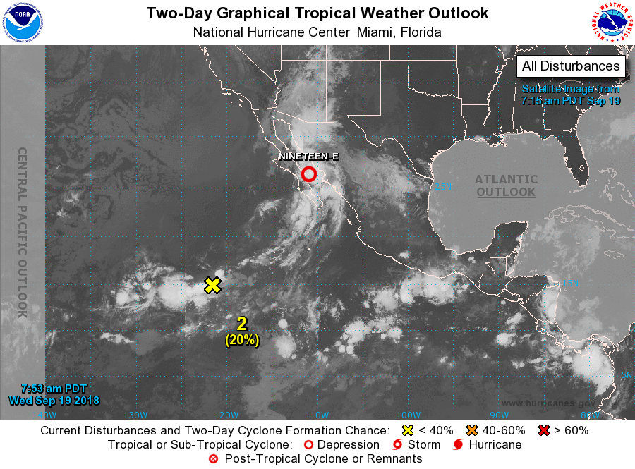
SUMMARY OF 900 AM MDT...1500 UTC...INFORMATION
----------------------------------------------
LOCATION...26.3N 110.9W
ABOUT 35 MI...60 KM NE OF LORETO MEXICO
ABOUT 115 MI...190 KM S OF GUAYMAS MEXICO
MAXIMUM SUSTAINED WINDS...30 MPH...45 KM/H
PRESENT MOVEMENT...N OR 10 DEGREES AT 13 MPH...20 KM/H
MINIMUM CENTRAL PRESSURE...1004 MB...29.65 INCHES
WATCHES AND WARNINGS
--------------------
There are no coastal watches or warnings in effect.
Interests in northwestern Mexico should monitor the progress of
Tropical Depression Nineteen-E.
DISCUSSION AND OUTLOOK
----------------------
At 900 AM MDT (1500 UTC), the center of Tropical Depression
Nineteen-E was located near latitude 26.3 North, longitude 110.9
West. The depression is moving toward the north near 13 mph (20
km/h) and this motion is expected to become more north-northeast
tonight with a similar forward motion until the system dissipates on
Thursday. On the forecast track the depression is forecast to move
inland over northwestern Mexico this evening.
Maximum sustained winds are near 30 mph (45 km/h) with higher gusts.
No significant strengthening is expected before the system moves
inland over mainland northwestern Mexico, then steady weakening is
forecast.
The estimated minimum central pressure is 1004 mb (29.65 inches).
HAZARDS AFFECTING LAND
----------------------
RAINFALL: Tropical Depression Nineteen-E is expected to produce
total rainfall accumulations of 5 to 10 inches, with isolated
maximum amounts of 15 inches across portions of Baja California Sur,
Sinaloa, and Sonora through Thursday. This rainfall could cause
life-threatening flash floods and mudslides. Moisture from this
disturbance will also lead to areas of heavy rainfall and a risk of
flash flooding in the southwestern United States beginning today.
NEXT ADVISORY
-------------
Next complete advisory at 300 PM MDT.
$$
Forecaster Roth/Blake
WTPA31 PHFO 012040
TCPCP1
BULLETIN
Hurricane Walaka Advisory Number 9
NWS Central Pacific Hurricane Center Honolulu HI CP012018
1100 AM HST Mon Oct 01 2018
...CATEGORY 4 HURRICANE WALAKA STILL INTENSIFYING FAR SOUTHWEST OF
HAWAII...
SUMMARY OF 1100 AM HST...2100 UTC...INFORMATION
-----------------------------------------------
LOCATION...12.9N 169.3W
ABOUT 265 MI...425 KM S OF JOHNSTON ISLAND
ABOUT 950 MI...1530 KM SW OF HONOLULU HAWAII
MAXIMUM SUSTAINED WINDS...150 MPH...240 KM/H
PRESENT MOVEMENT...NW OR 305 DEGREES AT 10 MPH...17 KM/H
MINIMUM CENTRAL PRESSURE...930 MB...27.47 INCHES
Partilhar:


