Seg.Esp. Chuva e Trovoada: Sistema depressionário «Fabiana» - 10/13 Outubro 2008

  • Thread starter Thread starter Vince
  • Data de início Data de início
Bem, incrivel o dia que está, 30ºC de máxima e agora 25ºC com pouco vento ainda quente e abafado.

Nos modelos o GFS das 12z desagravou muito a situação para a madrugada no Algarve deixando quase tudo no mar. O Hirlam das 12z mantem.

a-25.gif


b-20.gif
 
Já se vêm no mar relampagos e ráios frequentes mas chuva ainda nada. A temperatura já desceu para os 21º o vento que depois da calma soprava moderado de sul, agora sopra moderado de SSE com rajadas de 40km/h... tá aqui à porta :D
 
Já se vêm no mar relampagos e ráios frequentes mas chuva ainda nada. A temperatura já desceu para os 21º o vento que depois da calma soprava moderado de sul, agora sopra moderado de SSE com rajadas de 40km/h... tá aqui à porta :D

Grande sorte... :sad::sad:
Por aqui só há bastante vento (+/- uns 30 km/h) e céu muito nublado... NADA de chuva ou trovoada, nem um relâmpago sequer... :sad::(
 
]ToRnAdO[;89811 disse:
Já começou ai em olhao??

Viva ao tempo tropical viva as trovoadas caribenhas!
Ate em sines estao 24Cº e o ar mais fresco em olhao deve ser devido a correntes descendentes de ar frio dentro da celula e da respectiva mesofrente ( rejada brusca de ar que saiu da celula em todas as direcções e que é indicador da proximidade da trovoada).
Aqui em lisboa esta calor e o ceu mto nublado esperemos por amanha...
 
Último Estofex dá mais importância ao interior centro/norte para a tarde/noite de amanhã.
Esta previsão não inclui a próxima madrugada no Algarve, que faz parte da previsão anterior.

showforecastcgi-2.png


SYNOPSIS

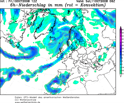
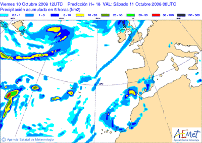
An omega-type upper flow pattern is expected to establish over Europe during the period, with the two corresponding upper cyclones being located over SW Iberia/N Morocco and over the eastern Mediterranean, respectively. Ample upper westerly flow is present N of this configuration over Scandinavia towards western Russia. The low-level pressure field reflects this upper-level pattern, with a large high over central portions of Europe and the central Mediterranean, WAA and cyclonic flow over the SW Mediterranean/Iberia ... and large SFC low complexes over the N Atlantic and Scandinavia.

DISCUSSION

... Iberian Peninsula ...

Substantial instability will likely persist amidst plume of warm/moist air spreading northwards E of the SW-European upper low. GFS advertises integrated CAPEs in excess of 3000 kJ/m^2. Deep shear should be maximized in a region including SE Spain and the SW Mediterranean Sea, gradually decreasing towards the NW. In this region, maximum bulk shear is simulated to exceed 35 m/s in the lowest 6 km. LLS should also be maximized over the eastern parts if the peninsula, as well as over the north, with common values in the 10 to 12 m/s range.

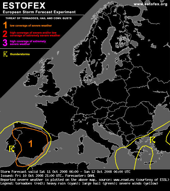
Although the best shear should remain somewhat offset from the deepest/richest instability, deep convection will likely be sustained in the strongly-sheared regime, potentially evolving into well-organized thunderstorms, including (bowing) line segments and supercells. Strong LLS and low LCL heights suggest that tornadoes will be possible, along with damaging wind gusts and large hail. Given weak capping and sustained ascent, the storms will likely last well into the evening/night.

It seems that the maximum DLS will be somewhat displaced from most favorable LLS, also, the convection seems to be struggling somewhat to develop/become organized as of late Friday evening. Will thus only issue a level-one threat at this time, but an upgrade may become necessary on Saturday.
 
Aqui estão uns impressionantes 24,7ºC a esta hora e uma brisa quente de ENE.

Noite de fazer inveja a 90% (ou mais) das noites de verão....

A temperatura não sofreu qualquer variação na última hora e estão +9,4ºC que ontem à mesma hora :p
 
Aqui estão uns impressionantes 24,7ºC a esta hora e uma brisa quente de ENE.

Noite de fazer inveja a 90% (ou mais) das noites de verão....

A temperatura não sofreu qualquer variação na última hora e estão +9,4ºC que ontem à mesma hora :p

Completamente de acordo Hotspot :thumbsup:

Eu estou com uns impressionantes 24.5ºC nunca tive uma temperatura tão alta este ano :lmao: a esta hora.
 
Donde virao aquelas DEA´s que o IM pos no mapa de trovoadas?????
Infelizmente cada vez confio menos no nosso IM...se ao menos fossem um decimo da AEMET ......

Bem eu acho que o ESTOFEX esta a fazer um bom trabalho mas devia por o nivel 1 tambem sobre todo o territorio portugues pois a situaçao é preocupante ate porque ja se formam agora pequenas celulas no SE alentejano e a sul do algarve ja temos temporal.
boas:thumbsup: