Estender-se-ão as monções à Europa?
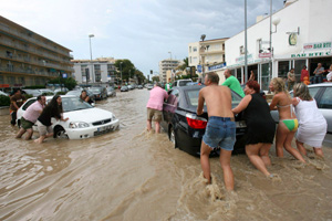
‘European monsoon’ could make this one of the wettest summers on record
SUNSEEKERS disappointed by yesterday’s unseasonal downpours across large swathes of the nation could at least take some comfort from the record books last night. For the record-breaking downpours some had been predicting failed to fully materialise – with the deluge of 63mm in 12 hours a long way off the 279mm that fell in the same period on July 11, 1955. But those figures would have been of little solace to parts of the nation which suffered flooding yesterday.
Bridgend was among the worst- hit areas, with town centre traders battling three feet of floodwater and the nearby Coney Beach Amusement Park in Porthcawl closing due to the persistent rain. The town’s Merthyr Mawr Road was also shut for some time by flooding as were roads in Cornelly and Aberkenfig. And a gauge in Lletty Brongu, Maesteg, just above Bridgend, officially recorded it as the wettest place in Wales with 63mm (around two and a half inches) falling in the 12 hours to 5pm yesterday. On average in Wales, the total monthly rainfall is only 70mm.
But it was a long way off Britain’s wettest ever recorded day, 53 years ago in Dorchester. By comparison, Wales’ wettest ever day on record was November 11, 1929, when 211mm fell in the 12 hours between 9am and 9pm. Malcolm Weatherall, public weather adviser for the Meteorological Office, said: “We warned that some parts of South Wales could get up to a month’s rainfall... so we were not far off. “It was not a record-breaking day for rainfall as these tend to come when we get thunder and lightning but overall it was pretty wet.”
A rain gauge at St Athan, Rhoose, recorded 41mm of rain falling in the 12 hours to 5pm yesterday. Clive Barber, who runs Celtic Jewellers in Caroline Street in the centre of Bridgend had his premises flooded. He said: “It was coming through the toilets and a manhole cover blew its top. “I blame the planners for approving hundreds of homes without thinking about the extra sewerage and drainage that’s needed.”
The worst of the rain fell yesterday in a band stretching from Tenby in the west, across the Brecon Beacons to Newport in the east with only light rain at the National Eisteddfod in Llangollen in the north. While the Met Office’s longer-range forecast for the rest of the summer made for grim reading, Abergavenny-based Positive Weather Solutions had a slightly brighter outlook for the school holidays.
Forecaster Jonathan Powell predicted: “August will probably see the highest temperatures across the UK for the year, and the first two weeks of the month should see this occur, coupled with some fine and warm weather, and just the nagging threat of thunderstorms. “Through mid-month, whereas they will be some fine weather, some unsettled conditions will make their presence felt, and whereas this pattern will tend to continue as August draws to a close, there will be some fine and warm weather left, as we enter a wet but mild autumn. Temperatures will be above the average throughout August.”
The Met Office predicts more showery weather for the coming days with sunshine this Sunday and Monday and Tuesday but with the risk of showers and heavier rain might return by the end of next week. The bad weather could be down to a “
European monsoon”. The little-known phenomenon is leading some forecasters to predict that 2008 could be among the top five wettest summers on record.
The unsettled weather, which has sparked a number of severe weather warnings across Wales, is believed to be linked to the position of the jet stream which is further south than is normal for this time of year. Michael Dukes of forecasters MeteoGroup UK said the European monsoon is the name given to an early summer weather feature. He said: “Westerly winds predominate over the winter, bringing wet stormy weather in from the Atlantic Ocean, but tend to be superseded in spring when other winds come into play. It’s often called the return of the Westerlies or the European monsoon — it happens in most years — but in some years it is more evident than others.”
WalesOnline

 , segundo o meteoalarm o norte de itália vai estar em alerta laranja
, segundo o meteoalarm o norte de itália vai estar em alerta laranja


 .
. já para não falar nas vasta área que abrange.


já para não falar nas vasta área que abrange.


 hoje em espanhã


