nimboestrato
Nimbostratus
o que é q tornados teem a ver com depressoes????
Obviamente, que me referia a furacões.
o que é q tornados teem a ver com depressoes????
")


Reino Unido Mau tempo isola centenas de atletas nas montanhas
Centenas de corredores que participavam numa maratona na montanha ficaram isolados pelo mau tempo que se fez sentir este sábado na Grã-Bretanha.
A prova, que decorria perto de Keswick na zona montanhosa do noroeste de Inglaterra, foi cancelada devido ao vento e à precipitação, que na na área da corrida atingiu os 65 milímetros.
De início, o desaparecimento de 900 dos cerca de 2.500 participantes fez temer o pior, mas a intempérie não chegou a fazer vítimas. “É provavelmente o pior dia que já vi na minha vida na região…era granizo e chuva horizontal..rajadas de mais de 100 quilómetros por hora. Foi algo que eu nunca tinha experimentado” tetstemunhou um dos participantes.
A maior parte dos atletas que ficaram encurralados na montanha teve de procurar abrigos provisórios em tendas ou foi recolhida por agricultores da zona. Apesar de alguns rios terem transbordado, as equipas de salvamento hospitalizaram apenas 12 pessoas, com ferimentos ligeiros e hipotermia.
http://www.euronews.net/pt/article/26/10/2008/mountain-runners-rescued-in-uk-race/


 [/
[/


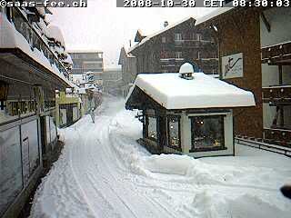


Neige en Mayenne
la nationale 162 se débloque peu à peu
Suite à l’intervention des services de l’Équipement, la circulation se débloque peu à peu sur la nationale 162 entre Mayenne et Laval.
Les fortes chutes de neige de ce matin ont bloqué pendant plusieurs heures la nationale 162 en direction de Laval, à hauteur de Martigné-sur-Mayenne. Beaucoup de poid-lourds, ne pouvant pas franchir les côtes, ont été contraints de s’arrêter directement sur les routes, ralentissant l’intervention des services de l’Équipement et créant un fort ralentissement s’étendant sur près de sept kilomètres. La circulation, bloquée jusqu’à 11 heures ce matin, est en train d’être rétablie.
Les services de l'Équipement sont par ailleurs intervenus dès 8h sur la nationale 12, notamment côte des Cheminées, en direction de Pré-en-Pail. On circule a peu près normalement dans ce secteur.
En revanche, la situation est toujours délicate sur l'autoute A81 entre La Gravelle et Le Mans, où on circule à 50/60 km/heure.
http://www.ouest-france.fr/Neige-en...-peu/re/ofdernmin/_-733136--BKN----_actu.html
La neige arrive dans l'Ouest
La neige est arrivée dans l’ouest ce matin ! Si la plupart des départements ne sont pas encore touchés, d’autres ont vu les flocons tomber avec abondance. C’est notamment le cas de la Mayenne.
http://www.ouest-france.fr/La-neige-arrive-dans-l’ouest/re/actuDet/actu_3631-733078------_actu.html
PAYS DE LA LOIRE.
C’est en Mayenne que les flocons sont tombés avec le plus d’abondance ce matin. Il neige depuis 7h ce matin, du Sud-Est du département au Nord. On n'avait pas vu ça en octobre depuis 28 ans. Les précipitations sont surtout concentrées sur la zone de Laval, où il est tombé entre 3 et 5 cm. Il devrait continuer de neiger jusqu'à la mi-journée.
Les précipitations devraient progressivement s'étendre au Nord du département, notamment dans la région de Pré-en-Pail. Météo-France redoute surtout la nuit prochaine : « Il devrait à nouveau neiger. Sur des sols plus froids, les chaussées risquent de devenir plus glissantes ».
NORMANDIE.
Le Bocage Virois connaît ce matin ses premières chutes de neige fondue. « Pas de danger pour la circulation », indique la gendarmerie. « La neige ne tient pas sur la chaussée quand elle est humide ». Les automobilistes circulent avec prudence. Pour l'instant, aucun incident n'est à signaler.
Dans la Hague, près de Cherbourg, ce ne sont encore que des flocons fondus, mais la neige a fait son apparition. Mêlée à la pluie, elle n'a pas tenu. La température est tombée à 2°. Une situation exceptionnelle pour un 30 octobre.
Le département de l'Orne s'est réveillé avec 5 centimètres de neige sur les hauteurs. Pas de perturbations à noter pour l'instant sur les routes. La vigilance reste de rigueur avec des chutes de pluie mêlée de neige annoncées cet après-midi.
BRETAGNE.
Premières chutes de neige fondue de l’année pour le Pays de Vitré. Pas de danger pour la circulation. La neige ne tient pas sur la chaussée quand elle est humide.


Snow covers parts of England as winter weather sets in
London suffered its first October snowfall in 74 years as a winter chill set in across England.
Thousands of homes in Bedfordshire, Hertfordshire and Buckinghamshire were left without power after the cold weather damaged high voltage cables.
Supplier EDF Energy said the bad weather has prevented engineers from fixing the problem.
Luton Airport was forced to divert a number of its flights on Tuesday evening while airport workers cleared snow from the runway.
The seven flights were diverted to Birmingham and Stansted airports.
There was major disruption on the motorways after two lorries were involved in accidents during the morning rush hour: one on the M40 in Oxfordshire, closing the motorway, and another on the M65 in Lancashire.
The Highways Agency said it was not clear if the weather conditions had contributed to each of the accidents. A spokesman said: "Both of the roads in question had been gritted so it is not clear what part the weather conditions played."
In Scotland, conditions were returning to normal after heavy snow and high winds brought disruption to roads earlier this week but temperatures remained very low.
Snow fell in London for the first time in October since 1934, while thermometers fell below zero across the country. Hertfordshire saw up to two inches of snow.
With road gritters out in some areas, night-time temperatures dropped to a bitter 24F (-4C) in eastern England last night with similar lows forecast for tonight. In northern Scotland, gale force winds left temperatures feeling much lower.
Even daytime conditions were unseasonably cold, with Manchester managing a high of only 41F (5C) compared to the 51F (10C) usually expected at this time of year.
As commuters in Coventry made their home from work through snow showers a handful appeared to be basking under bright clear skies on Brighton beach.
But appearances can be deceptive. While the Sussex coast was the warmest spot in Britain, temperatures there reached only 48F (9C) - and only briefly.
"I think they are very brave," said Met Office forecaster Kevin Hogg.
While cloud is expected to move in from the west during today, lifting temperatures slightly, Britain is in for a second night of below-freezing conditions.
The wintry conditions mark the end of the mild conditions which have allowed one of the best shows of autumn colour from Britain's trees in recent years.
Forecasters are blaming a change in wind direction for the wintry spell with Arctic gusts replacing the mild south-west Atlantic breezes enjoyed in recent weeks.
http://www.telegraph.co.uk/news/ukn...rts-of-England-as-winter-weather-sets-in.html

