Seguimento Europa - 2008
- Thread starter Mário Barros
- Data de início
-
O novo portal está no ar! Novos meteogramas, cartas, e mais. Mais informações neste tópico
Seguimento Meteorológico: Litoral Norte | Interior Norte e Centro | Litoral Centro | Sul | Açores e Madeira | Livre
Previsões: Curto e médio prazo: até 2 semanas | Longo prazo: mensal e sazonal (Regras e links úteis nos 1ºs posts)
Facebook | Avisos IPMA/Alertas ANEPC
You are using an out of date browser. It may not display this or other websites correctly.
You should upgrade or use an alternative browser.
You should upgrade or use an alternative browser.


AnDré
Moderação
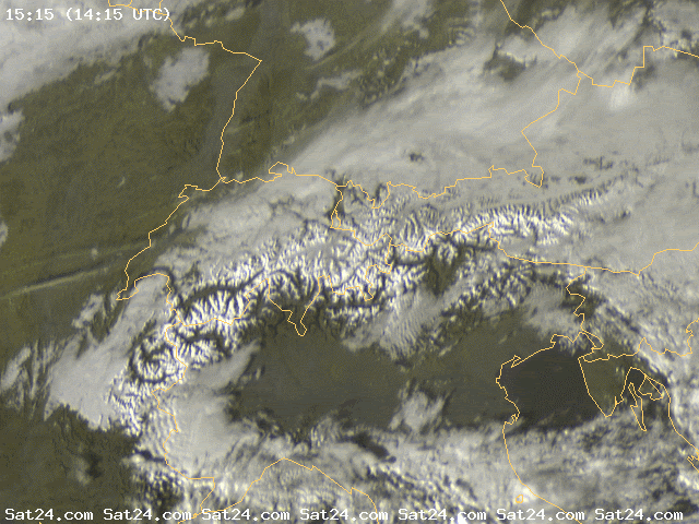
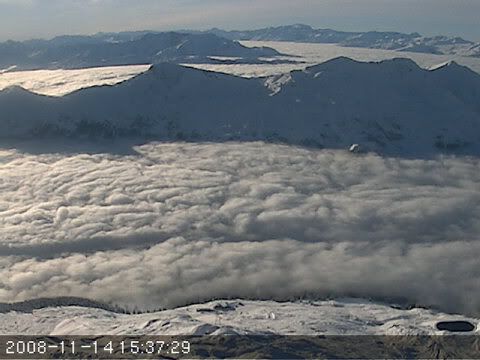
Hoje, e especialmente na fronteira entre a Suíça e a Áustria, há bastante nevoeiro nos vales dos Alpes, como se pode ser pelo satélite e pelas webcams:
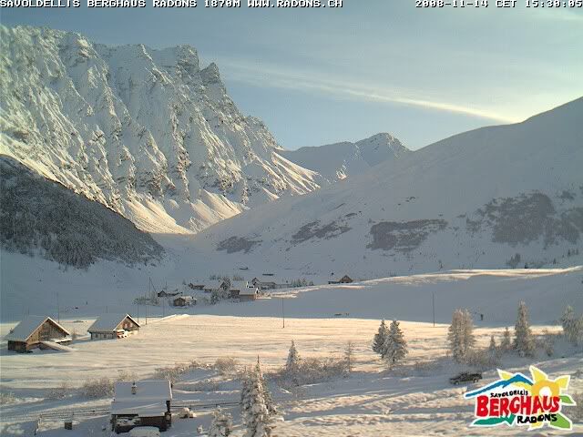
Devido aos fortes nevões dos últimos dias, há lugares que estão incrivelmente belos, e onde até já deve cheirar a Natal.
Como por exemplo aqui:
 :rolleyes:")
Devido aos fortes nevões dos últimos dias, há lugares que estão incrivelmente belos, e onde até já deve cheirar a Natal.
Como por exemplo aqui:
Daniel Vilão
Super Célula
Devido aos fortes nevões dos últimos dias, há lugares que estão incrivelmente belos, e onde até já deve cheirar a Natal.
Como por exemplo aqui:
Absolutamente soberbo.
Lindíssimo, esse local.

MSantos
Moderação

Chasing Thunder
Cumulonimbus
Aviso do Estofex para Hoje dia 15 de Novembro.

SYNOPSIS
Rather intense, meandering upper westerlies are covering the northern and eastern parts of Europe. Feature of most interest in this flow regime will be the trough to be expected off the Scandinavian W coast at the beginning of the period. This feature will lift northeastwards during the period but in doing so, maintain strong cyclogenesis over the North Sea and southern Scandinavia. Over the central Mediterranean, a quasi-stationary upper cyclone persists through the period.
DISCUSSION
... Baltic region ... S Sweden ...
It appears that strong slab ascent along the cold front associated with the Scandinavian trough will be accompanied by a narrow/shallow convective line, mainly affecting the Baltic Sea and the Baltic States, but later also N Germany and N Poland, with the convection becoming increasingly shallow towards the southwestern extension of the front. It is quite likely the this convection will be associated with very gusty winds as a result over vertical momentum transport, and so will mainly act to augment the strong/severe large-scale gradient flow. Near the apices of line segments, the strong vertical shear may be tilted into the vertical, so that mesocyclones/MCVs may form, which could spawn a brief tornado or two, though the background helicity is not extraordinarily strong per latest model guidance. Though CAPE signals are quite weak, sufficient confidence in convective development exists, necessitating a level one treat. Lightning activity should be confined to the deeper segments of the line over S Scandinavia and the Baltic region.
... central and western Mediterranean ...
Some instability will likely persist over the central Mediterranean underneath the upper thermal low, and in its periphery where a plume of wrap-around theta-e is present. Not the entire region where convection is expected, will benefit from vertical shear, but about 20 m/s 0-6 km bulk shear should be present over the Ionian Sea, S Italy, and the southern Adriatic Sea. Steepening lapse rates and increasing low-level shear are simulated over the Ionian Sea in the evening hours.
Thinking is that thunderstorms will persists throughout the period, with highest chances of organized thunderstorms existing over southern Italy, the S Adriatic, and the S Ionian Sea, where kinematic support will be best. Expect isolated marginally severe hail along with severe wind gusts with the strongest of these storms.
As thermodynamic and kinematic fields strengthen over the Ionian Sea towards the evening, more intense severe weather, including tornadoes may occur.
Farther west, where shear profiles are weaker, strong low-level lapse rates are anticipated, hinting at the possibility of non-mesocyclonic tornadoes. These should be too isolated in nature to warrant a categorical outlook for this phenomenon.
Sul de Itália.
 [/
[/
Grécia
[URL=http://imageshack.us] [/
[/
Tanto que eu gostava que cá em portugal também estevesse em festa
SYNOPSIS
Rather intense, meandering upper westerlies are covering the northern and eastern parts of Europe. Feature of most interest in this flow regime will be the trough to be expected off the Scandinavian W coast at the beginning of the period. This feature will lift northeastwards during the period but in doing so, maintain strong cyclogenesis over the North Sea and southern Scandinavia. Over the central Mediterranean, a quasi-stationary upper cyclone persists through the period.
DISCUSSION
... Baltic region ... S Sweden ...
It appears that strong slab ascent along the cold front associated with the Scandinavian trough will be accompanied by a narrow/shallow convective line, mainly affecting the Baltic Sea and the Baltic States, but later also N Germany and N Poland, with the convection becoming increasingly shallow towards the southwestern extension of the front. It is quite likely the this convection will be associated with very gusty winds as a result over vertical momentum transport, and so will mainly act to augment the strong/severe large-scale gradient flow. Near the apices of line segments, the strong vertical shear may be tilted into the vertical, so that mesocyclones/MCVs may form, which could spawn a brief tornado or two, though the background helicity is not extraordinarily strong per latest model guidance. Though CAPE signals are quite weak, sufficient confidence in convective development exists, necessitating a level one treat. Lightning activity should be confined to the deeper segments of the line over S Scandinavia and the Baltic region.
... central and western Mediterranean ...
Some instability will likely persist over the central Mediterranean underneath the upper thermal low, and in its periphery where a plume of wrap-around theta-e is present. Not the entire region where convection is expected, will benefit from vertical shear, but about 20 m/s 0-6 km bulk shear should be present over the Ionian Sea, S Italy, and the southern Adriatic Sea. Steepening lapse rates and increasing low-level shear are simulated over the Ionian Sea in the evening hours.
Thinking is that thunderstorms will persists throughout the period, with highest chances of organized thunderstorms existing over southern Italy, the S Adriatic, and the S Ionian Sea, where kinematic support will be best. Expect isolated marginally severe hail along with severe wind gusts with the strongest of these storms.
As thermodynamic and kinematic fields strengthen over the Ionian Sea towards the evening, more intense severe weather, including tornadoes may occur.
Farther west, where shear profiles are weaker, strong low-level lapse rates are anticipated, hinting at the possibility of non-mesocyclonic tornadoes. These should be too isolated in nature to warrant a categorical outlook for this phenomenon.
Sul de Itália.
[/Grécia
[URL=http://imageshack.us]
[/Tanto que eu gostava que cá em portugal também estevesse em festa
AnDré
Moderação
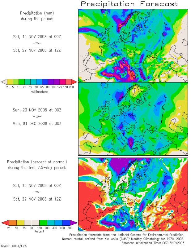
E o Mediterrâneo vai mesmo estar ao rubro durante a próxima semana, com algumas regiões a esperar quantidades de precipitação superiores a 200mm.
Chasing Thunder
Cumulonimbus
Aviso Do Estofex para hoje dia 16 Novembro.

SYNOPSIS
Two features dominate the weather pattern in the central parts of Europe: An upper cut-off low over the central Mediterranean translates towards Greece. At 500hPa, a 30 m/s jet streak over northern Libya will travel northeastward with its left exit region over SW Greece. Upstream of a low pressure complex located over the Baltic States, a strong upper trough will overspread the Baltic Sea and Poland during the day. Quiescent conditions will remain over southwestern and southeastern Europe where an upper ridge is present.
DISCUSSION
...Central Mediterranean, Ionian Sea...
Moderate CAPE is in place over the central / eastern Mediterranean in an environment with low to moderate deep layer shear (10 - 20 m/s). As the upper low weakens, QG forcing will be limited but moderate shear may allow some organized multicells. Some of them may develop rotating updrafts and produce isolated large hail / severe gusts. Especially in the western part of the area where shear is rather weak, steep low level lapse rates and low LCL heights should lead to some waterspouts.
...NE Germany, Poland, W Belarus...
A vigorous upper vort max associated with an upper shortwave trough will overspread parts of central / eastern Europe during the afternoon / evening hours. Wind speeds around 20 m/s are present at 850hPa and vertical cross sections hint at potential instability next to the cold front ahead of the trough. Even though instability is very limited and horizontal temperature gradients are rather low, one or two shallow convective lines with sporadic lightning may evolve and downward momentum transport will allow convectively enhanced gusts that exceed the severe threshold. As low level shear is in order of 15 m/s and orographic features may provide significant directional shear, tornadoes are not discounted either. Overall threat should reach the level one threshold.
Estes run's tem sido de loucos para a Escandinávia quem me dera meter-me já no avião para lá ir passar os próximos 10 dias.

A anomalia na Europa pouco a pouco está a ficar cada vez mais negativa e Portugal não escapa, todo aquele veremlho deve desaparecer nos próximos dias.

quem me dera meter-me já no avião para lá ir passar os próximos 10 dias.A anomalia na Europa pouco a pouco está a ficar cada vez mais negativa
e Portugal não escapa, todo aquele veremlho deve desaparecer nos próximos dias.Chasing Thunder
Cumulonimbus
Aviso do Estofex para hoje dia 17 de Novembro")

SYNOPSIS
Strengthening high pressure over the eastern Atlantic arches upward while blocking the predmoinant upper zonal flow pattern over the N-Atlantic. Geopotential heights begin to fall over most parts of N/CNTRL and E- Europe during the day and mark the beginning of a much colder period for most parts of Europe. Weakening upper trough over the central Mediterranean shifts eastwards, before re-gaining strength during the night hours, as geopotential height falls reach the Mediterranean. A few lightning strikes are possible during the passage of very cold upper trough over NW Norway, 00Z onwards.
DISCUSSION
... Crete, S-Aegean Sea ...
As upper trough draws near from the west during the day, atmosphere at all levels starts a gradual cool-down. SSTs in the upper tens/lower twenties still present, so expect a fair amount of instability, especially at lowest 2-3km. Background flow in general remains weak with DLS of 10-15m/s despite numerous short-lived flare-ups as small-scale disturbances pass by. BL airmass remains humid and LCLs low, so risk of waterspouts will be enhanced over an extensive area, especially if local convergence zones can set up. Degree of LL CAPE release and locally enhanced DLS even hint on an isolated strong tornado event. Despite overall weak shear, DLS of near 20m/s over Crete, a lowering WBZ level and some modest mid-level CAPE release indicate a risk of large hail with stronger storms. Overall, parameters look fine for numerous tornado/hail events but we first want to wait for new model data before updating.
A potência que se está a cozinhar para a Escandinávia é algo incrivel, penso que eles poderão estar há beira de uma tempestade tipica dos anos 70
Vão levar com um nevão que já não vêem há muito muito tempo.

2 de Dezembro de 1976

Vão levar com um nevão que já não vêem há muito muito tempo.
2 de Dezembro de 1976
AnDré
Moderação
A potência que se está a cozinhar para a Escandinávia é algo incrivel, penso que eles poderão estar há beira de uma tempestade tipica dos anos 70
Vão levar com um nevão que já não vêem há muito muito tempo.
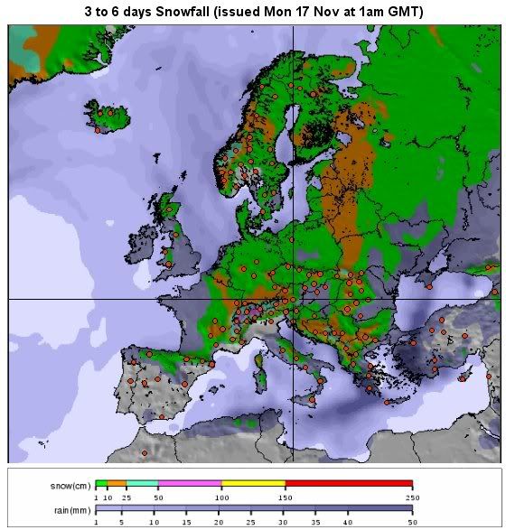
As previsões apontam para acumulações de neve, dignas de inverno. E um pouco por toda a Europa.
Quer dizer, estou ali a ver um rectângulo no extremos sudoeste que...
Enfim, é o costume!

Chasing Thunder
Cumulonimbus
Aviso do Estofex para hoje dia 18 de Novembro.

SYNOPSIS
A blocking high pressure system lies over the Atlantic. Two troughs enter Europe with the northwestern flow, connected by a cold front. The strongest ascending QG motions are forecast over Denmark, Germany, Czech Republic and Poland, and over the southern half of France sliding into the western Mediterranean area. Another trough with a more unstable airmass affects the area around Greece and Turkey.
DISCUSSION
...Crete, Aegean Sea, southwestern Turkey...
Relatively large CAPE (>1000 J/kg) and moderate vertical shear (15-25 m/s) offer potential for strong multicell clusters or MCS storms with a chance of large hail. While SREH is not strong, some storms may exhibit rotation. Flash flooding may occur.
...Denmark, Germany, Czech Republic, western Poland...
An area of some CAPE, ELs to -15°C and strong shear follows after the cold front during the evening. SREH >200 m2/s2 and LLS > 10 m/s in combination with CAPE require alertness for isolated tornadoes. However, the GFS model predicts a heavy inversion between 2 and 4 km altitude and unfavorable positioning to QG ascent, and a strong convergence zone is absent, so chances for severe weather seem too marginal.
...Mediterranea Sea...
Waterspouts may occur, especially where the combination of strong LL buoyancy, moisture, convergence and weak winds are present.
Chasing Thunder
Cumulonimbus
Aviso do Estofex para Hoje dia 19 de Novembro.

SYNOPSIS
Between an intense 1040hPa high pressure area over the NE Atlantic and a large-scale cyclonic vortex over extreme N-Europe, geopotential height gradients get worse and bitterly cold air from Greenland starts its move toward the SE. This period will be the prominent 'calm before the storm' for many parts of N/CNTRL and S-Europe so the upcoming 24h remain relative quiet regarding organized and deep convection. Geopotential heights remain low over the western/central Mediterranen so chances for a few thunderstorms remain. Latest soundings reveal well mixed LLs with locally enhanced lapse rates at lowest 3km and strongest convergence signals over the western Mediterranean indicate that most of the activity will be confined to this area (running from SE Spain, the Balearic Islands to Corsica). Strong wind gusts, marginal hail and an isolated waterspout could occur with stronger activity, but threat remains marginal throughout the period. There are some hints on a low-end thunderstorm risk over Latvia during the early morning hours of the 20th, but confidence is not yet high enough to go with a thunderstorm area.
DISCUSSION
... An area NE/E of Crete and coastal areas of W/SW Turkey ...
A departing and gradually filling upper trough affects the area during the forecast. Temperatures at all levels cool off constantly, resulting in steepening lapse rates at all levels keeping SSTs of 16°C (northern level area) to 21°C (extreme southern level area) in mind. A weak cold front slowly drops south/southeastwards, swamping the warm/humid air out of the area. Hence, SBCAPE values in excess of 1500 J/kg during the morning to midday hours should decrease betimes and tongue of strongest instability should exit the forecast area during the night hours. LCLs are low, atmosphere only weakly capped and 0-3km CAPE release very robust, so there will be an appreciable risk for waterspouts mainly along the W/SW coast of Turkey. 12Z soundings from Crete and W-Turkey already had nice lapse rates, which should become steeper betimes, so in combination with intense updraft strength ( large LL/mid-level CAPE release) and aforementioned, potential rapid LL vortex stretching, even an isolated strong tornado event will be possible. In addition, large hail will be also a threat in stronger storms.
The hail and tornado threat remains augmented east of Crete, where DLS increases and deep-layer updraft rotation seems likely.
Thunderstorm intensity/coverage should decrease after 21Z and exit the area of responsibility.


Partilhar: