Irá passar nas redondezas de uma boia amanhã  https://www.ndbc.noaa.gov/ https://www.ndbc.noaa.gov/station_page.php?station=41043
Previsão e Seguimento de Furacões (Atlântico 2025)
- Thread starter Orion
- Data de início
-
O novo portal está no ar! Novos meteogramas, cartas, e mais. Mais informações neste tópico
Seguimento Meteorológico: Litoral Norte | Interior Norte e Centro | Litoral Centro | Sul | Açores e Madeira | Livre
Previsões: Curto e médio prazo: até 2 semanas | Longo prazo: mensal e sazonal (Regras e links úteis nos 1ºs posts)
Facebook | Avisos IPMA/Alertas ANEPC
You are using an out of date browser. It may not display this or other websites correctly.
You should upgrade or use an alternative browser.
You should upgrade or use an alternative browser.

StormRic
Furacão
Previsão anterior (18A) do NHC foi largamente ultrapassada.Reports from NOAA and Air Force Reserve Hurricane Hunter aircraft
indicate that maximum sustained winds have increased to near
145 mph (230 km/h) with higher gusts. Erin is a category 4
hurricane on the Saffir-Simpson Hurricane Wind Scale. Continued
rapid strengthening is expected today, followed by fluctuations in
intensity through the weekend.
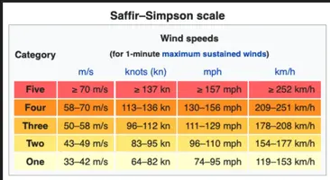
Erin é Cat.5 agora, >137 nós (>252 Km/h).
"455
WTNT65 KNHC 161520
TCUAT5
Hurricane Erin Tropical Cyclone Update
NWS National Hurricane Center Miami FL AL052025
1120 AM AST Sat Aug 16 2025
...AIR FORCE RESERVE HURRICANE HUNTERS FIND ERIN IS NOW A
CATASTROPHIC CATEGORY 5 HURRICANE...
Reports from an Air Force Reserve Hurricane Hunter aircraft
indicate that Erin has become a Category 5 hurricane on the
Saffir-Simpson Hurricane Wind Scale with maximum sustained winds
near 160 mph (255 km/h). The minimum pressure has fallen to near
917 mb (27.08 inches). The next intermediate advisory will be issued
at 200 PM AST (1800 UTC).
SUMMARY OF 1120 AM AST...1520 UTC...INFORMATION
----------------------------------------------
LOCATION...19.7N 62.8W
ABOUT 105 MI...170 KM N OF ANGUILLA
MAXIMUM SUSTAINED WINDS...160 MPH...255 KM/H
PRESENT MOVEMENT...W OR 280 DEGREES AT 17 MPH...28 KM/H
MINIMUM CENTRAL PRESSURE...917 MB...27.08 INCHES
$$
Forecaster Beven/Kelly"
Anexos
StormRic
Furacão
Irá passar nas redondezas de uma boia amanhã
Já não deve. Ainda assim:
StormRic
Furacão
Discussão 22
Conclusão: mais 24 horas em categoria 5 e mantendo "Majo5 Hurricane" até pelo menos a 120 horas (5 dias).
"FORECAST POSITIONS AND MAX WINDS
INIT 16/2100Z 20.0N 64.0W 140 KT 160 MPH
12H 17/0600Z 20.4N 65.7W 140 KT 160 MPH
24H 17/1800Z 21.4N 67.6W 140 KT 160 MPH
36H 18/0600Z 22.7N 69.2W 135 KT 155 MPH
48H 18/1800Z 24.0N 70.2W 130 KT 150 MPH
60H 19/0600Z 25.5N 70.9W 125 KT 145 MPH
72H 19/1800Z 27.3N 71.3W 120 KT 140 MPH
96H 20/1800Z 31.7N 70.8W 110 KT 125 MPH
120H 21/1800Z 36.8N 65.0W 100 KT 115 MPH"
StormRic
Furacão
Mas logo a seguir voltou a Cat.4, 240 Km/h, e subiu a pressão central.
"000
WTNT35 KNHC 162348
TCPAT5
BULLETIN
Hurricane Erin Intermediate Advisory Number 22A
NWS National Hurricane Center Miami FL AL052025
800 PM AST Sat Aug 16 2025
...NOAA AND AIR FORCE HURRICANE HUNTER AIRCRAFT SUGGEST THAT ERIN IS
UNDERGOING AN EYEWALL REPLACEMENT CYCLE...
SUMMARY OF 800 PM AST...0000 UTC...INFORMATION
----------------------------------------------
LOCATION...20.0N 64.6W
ABOUT 160 MI...255 KM NW OF ANGUILLA
ABOUT 150 MI...235 KM NE OF SAN JUAN PUERTO RICO
MAXIMUM SUSTAINED WINDS...150 MPH...240 KM/H
PRESENT MOVEMENT...W OR 275 DEGREES AT 15 MPH...24 KM/H
MINIMUM CENTRAL PRESSURE...934 MB...27.58 INCHES
StormRic
Furacão
Erin mantendo-se como furacão maior ("major hurricane"), agora em categoria 3 depois de passar por cat.5 durante poucas horas.
Dias 16 e 17 (utc), 48 horas.

Aviso #26
"FORECAST POSITIONS AND MAX WINDS
INIT 17/2100Z 21.7N 68.5W 110 KT 125 MPH
12H 18/0600Z 22.8N 69.7W 115 KT 130 MPH
24H 18/1800Z 24.0N 71.0W 125 KT 145 MPH
36H 19/0600Z 25.4N 71.9W 120 KT 140 MPH
48H 19/1800Z 27.1N 72.5W 115 KT 130 MPH
60H 20/0600Z 29.0N 73.0W 110 KT 125 MPH
72H 20/1800Z 31.2N 72.7W 105 KT 120 MPH
96H 21/1800Z 35.3N 69.3W 95 KT 110 MPH
120H 22/1800Z 40.3N 59.5W 85 KT 100 MPH
$$
Forecaster Pasch"
Actualização às 00:00 utc, aviso público 26A
"BULLETIN
Hurricane Erin Intermediate Advisory Number 26A
NWS National Hurricane Center Miami FL AL052025
800 PM AST Sun Aug 17 2025
...LIFE-THREATENING SURF AND RIP CURRENTS LIKELY ACROSS THE U.S.
EASTERN SEABOARD AS ERIN BECOMES A VERY LARGE HURRICANE THIS WEEK...
SUMMARY OF 800 PM AST...0000 UTC...INFORMATION
----------------------------------------------
LOCATION...22.1N 68.8W
ABOUT 310 MI...500 KM NW OF SAN JUAN PUERTO RICO
ABOUT 155 MI...245 KM ENE OF GRAND TURK ISLAND
MAXIMUM SUSTAINED WINDS...125 MPH...205 KM/H
PRESENT MOVEMENT...WNW OR 300 DEGREES AT 13 MPH...20 KM/H
MINIMUM CENTRAL PRESSURE...946 MB...27.94 INCHES"
Dias 16 e 17 (utc), 48 horas.
Aviso #26
"FORECAST POSITIONS AND MAX WINDS
INIT 17/2100Z 21.7N 68.5W 110 KT 125 MPH
12H 18/0600Z 22.8N 69.7W 115 KT 130 MPH
24H 18/1800Z 24.0N 71.0W 125 KT 145 MPH
36H 19/0600Z 25.4N 71.9W 120 KT 140 MPH
48H 19/1800Z 27.1N 72.5W 115 KT 130 MPH
60H 20/0600Z 29.0N 73.0W 110 KT 125 MPH
72H 20/1800Z 31.2N 72.7W 105 KT 120 MPH
96H 21/1800Z 35.3N 69.3W 95 KT 110 MPH
120H 22/1800Z 40.3N 59.5W 85 KT 100 MPH
$$
Forecaster Pasch"
Actualização às 00:00 utc, aviso público 26A
"BULLETIN
Hurricane Erin Intermediate Advisory Number 26A
NWS National Hurricane Center Miami FL AL052025
800 PM AST Sun Aug 17 2025
...LIFE-THREATENING SURF AND RIP CURRENTS LIKELY ACROSS THE U.S.
EASTERN SEABOARD AS ERIN BECOMES A VERY LARGE HURRICANE THIS WEEK...
SUMMARY OF 800 PM AST...0000 UTC...INFORMATION
----------------------------------------------
LOCATION...22.1N 68.8W
ABOUT 310 MI...500 KM NW OF SAN JUAN PUERTO RICO
ABOUT 155 MI...245 KM ENE OF GRAND TURK ISLAND
MAXIMUM SUSTAINED WINDS...125 MPH...205 KM/H
PRESENT MOVEMENT...WNW OR 300 DEGREES AT 13 MPH...20 KM/H
MINIMUM CENTRAL PRESSURE...946 MB...27.94 INCHES"
Última edição:
joralentejano
Furacão
Alguns registos do furacão Erin:
Entretanto, além das casas quase dentro do mar, mas isso é problema em muito lado, faz-me confusão como é que numa zona costeira muito suscetível ao impacto de furacões existem este tipo de construções:
Entretanto, além das casas quase dentro do mar, mas isso é problema em muito lado, faz-me confusão como é que numa zona costeira muito suscetível ao impacto de furacões existem este tipo de construções:
Aristocrata
Super Célula
É normal que isto aconteça.Entretanto, além das casas quase dentro do mar, mas isso é problema em muito lado, faz-me confusão como é que numa zona costeira muito suscetível ao impacto de furacões existem este tipo de construções:
Por todo o lado, EUA incluídos, a areia de reposição na costa está a ficar presa nas inúmeras barragens construídas.
Sem a natural reposição, a costa fica fragilizada e estas construções ficam vulneráveis pela perda da areia com o passar dos anos (e das tempestades).
joralentejano
Furacão
Certo, mas nestas situações de tempestade é normal o mar avançar sempre muito e estas casas ficam vulneráveis. Certamente que têm estacas de madeira presas na areia para levantar as casas de forma a que nestas situações não sejam inundadas, mas ainda assim, por muito que se note que são resistentes, mais tarde ou mais cedo acabam por colapsar devido ao constante embate da água. Se ao menos fossem de pedra...É normal que isto aconteça.
Por todo o lado, EUA incluídos, a areia de reposição na costa está a ficar presa nas inúmeras barragens construídas.
Sem a natural reposição, a costa fica fragilizada e estas construções ficam vulneráveis pela perda da areia com o passar dos anos (e das tempestades).
É como as casas de madeira na zona dos tornados, embora seja uma força da natureza que leva tudo por onde passa, claro que no caso de casas de madeira pouco ou nada fica de pé.
Sabemos que nos EUA construções de madeira são bastante comuns, mas não deixa de fazer confusão tendo em conta que muitas zonas do país são afetadas por tempestades muito significativas.
StormRic
Furacão
Madeira é a matéria prima de construção mais barata nos EUA, mais do que betão, argila, pedra. Florestas de produção não faltam, e continuam a cortar as originais. É ainda um tipo de construção tradicional, que data desde as primeiras invasões europeias.Sabemos que nos EUA construções de madeira são bastante comuns, mas não deixa de fazer confusão tendo em conta que muitas zonas do país são afetadas por tempestades muito significativas.
StormRic
Furacão
Ciclone tropical Fernand (AL90) quase formado:


Há 3 minutos:

Há 3 minutos:
Última edição:
StormRic
Furacão
StormRic
Furacão
Tempestade Tropical 'Fernand' já está formada:

A previsão aponta para um pico de intensidade do vento máximo sustentado de 60 nós na 2ªfeira à tarde, declinando a partir daí.
Não está previsto atingir a categoria de furacão.
A trajectória prevista leva a Tempestade Tropical sempre bem longe de terra, incluindo a Leste da Bermuda e da Terra Nova, sendo depois levada pela corrente de Oeste muito a norte dos Açores, já como pós-tropical.
"
FORECAST POSITIONS AND MAX WINDS
INIT 23/2100Z 27.2N 61.4W 35 KT 40 MPH
12H 24/0600Z 29.0N 61.0W 40 KT 45 MPH
24H 24/1800Z 31.4N 60.3W 50 KT 60 MPH
36H 25/0600Z 33.6N 59.5W 55 KT 65 MPH
48H 25/1800Z 35.8N 58.5W 60 KT 70 MPH
60H 26/0600Z 38.2N 56.7W 55 KT 65 MPH
72H 26/1800Z 41.3N 54.0W 50 KT 60 MPH
96H 27/1800Z 47.0N 44.0W 40 KT 45 MPH...POST-TROP/EXTRATROP
120H 28/1800Z...DISSIPATED
"
Partilhar: