Previsão e Seguimento de Furacões (Atlântico 2025)

  • Thread starter Thread starter Orion
  • Data de início Data de início
Lembro-me perfeitamente de passar 2 sistemas tropicais em 92 pelos Açores. Nada de grande significancia, pelo menos pelo Faial.


Enviado do meu iPhone usando o Tapatalk
Foi o primeiro ciclone que me lembro ... Furacão Charlie ...

Pela Terceira ainda fez os seus estragos ...

Lembro me perfeitamente de na altura eu e a minha mãe nos refugiarmos na casa de uma vizinha e de todos os vizinhos ficarem juntos com o receio de algo pior ...

Lembro me de um vizinho que vinha da rua nos relatar que várias estradas estavam cortadas ...

Foi a primeira vez que senti aquela sensação de que algo grande estava a vir ...

A segunda vez foi no Furacão Tânia em 1995 no que para mim foi o pior furacão de que tenho memória a afetar a Terceira ...

Lembro me perfeitamente de estar com a minha mãe a segurar as portadas durante a noite pois parecia que tudo ia levantar voo ...

Foram tempos animados esses ...

Claro que depois houve o Lorenzo que afetou algumas ilhas de uma forma inédita mas curiosamente na Terceira a coisa foi mais calma porque a tempestade afetou mais o grupo ocidental e o sul do grupo central ...

O Furacão Tânia foi, certamente o ciclone mais potente que presenciei. Aqui no Faial os estragos foram bastante extensos!
O Tânia era já TT ao atingir os Açores e bem decapitado de convecção, em avançada fase de transição para extratropical. Proporcionou um potente sting jet que afetou bem as ilhas do grupo central.
Aquilo meteu susto ao medo! À volta da minha casa tinham dezenas de grandes metrosideros, não ficou um único de pé! Para não falar das telhas que voaram para o infinito, nunca mais ninguém as viu.

O Lorenzo foi potente, mas nem chegou aos tornozelos do fenómeno ocorrido no Tânia.
A grandeza do Lorenzo esteve na sua dimensão, inércia e o incrível strom surge. Se não fosse o mar, pouco o vento teria destruído. (Não estou a dizer que não houve estragos provocados pelo vento), porque houve.


Enviado do meu iPhone usando o Tapatalk
 
Última edição:
Localização central está definida:

GTWO-7D_20250911-18.webp
GTWO-2D_20250911-18_sat.webp


'Gabrielle' ainda não nasceu, mas o ECMWF 12z ignora a possibilidade de se formar um furacão.
Se nascer, e derivar cedo para norte, o ciclone tropical terá SST's de 28ºC até aos 35º N e 50º W.
 
Última edição:
'Gabrielle' vai nascer, desembaraçou-se do "ar seco e estável" que tem estado presente em anteriores previsões de evolução e a perspectiva de ambiente favorável ao desenvolvimento apareceu.

GTWO-7D_20250915-12.webp

NHC-2D_20250915-12.webp


Ainda sem 100% de certeza, já lá vão 18 dias sem um ciclone tropical no Atlântico no pico da época de furacões.

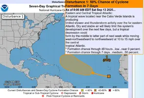
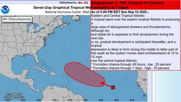
Anteriores previsões:
 

Anexos

  • GTWO-7D_20250913-12.webp
    GTWO-7D_20250913-12.webp
    117.3 KB · Visto: 7
  • GTWO-7D_20250914-18.webp
    GTWO-7D_20250914-18.webp
    116 KB · Visto: 6
Última edição:
Gabrielle quase formada, última previsão de trajectória segundo o ECMWF parece manter o eventual ciclone tropical longe de terra. Boas notícias para as Antilhas e costa Leste dos EUA mas más notícias para Bermuda. No entanto é uma previsão ainda a 9-10 dias, com continuação numa trajectória que poderá aproximar o CT do Grupo Ocidental dos Açores.

NHC-2D_20250915-18_tet.webp


GTWO-7D_20250915-18.webp


ECMWF_12z_0924-18_simIR_NA.webp


ECMWF_12z_0925-12__VMax10m-6h_MSLP_NAtlant.webp
 
Eis que nasce a Gabrielle. Espero que não tenha sido numa ambulância
Ainda não é a Gabrielle, é só a Depressão Tropical 'Seven' (foi numa ambulância, ainda não tem registo do nome... :rolleyes:)

E não vai ter evolução fácil de início, 'shear' de oeste e intrusões de ar seco estão ainda presentes no ambiente em que se situa.
Gabrielle pode vir a ser problemática quanto à previsão da intensidade, esperam-se surpresas...

"000
WTNT42 KNHC 170835
TCDAT2

Tropical Depression Seven Discussion Number 1
NWS National Hurricane Center Miami FL AL072025
500 AM AST Wed Sep 17 2025

Satellite data indicate that Invest 92L over the central tropical
Atlantic has now developed into a tropical depression. ASCAT data
from around 00Z showed that the circulation of the system had
improved, and although it was not well defined at the time of the
pass, the system was only lacking some northerly winds on its west
side. Since deep convection has been persisting and consolidating
near the center, it appears to now meet the convective and
circulation criteria needed to be considered a tropical cyclone.
However, it should be noted that the system is quite large and there
is still considerable north-south elongation in the low-level
structure. The initial intensity is set at 30 kt based on a blend of
the ASCAT data and the latest Dvorak estimate from TAFB. The
development of this system breaks a nearly 3-week streak of no
tropical cyclones in the Atlantic basin during the peak of the
hurricane season.

The depression is well away from land and roughly midway between the
Cabo Verde Islands and the Windward Islands. The system is
estimated to be moving westward at 11 kt, but this is of low
confidence
since the center has only recently formed. A turn to the
northwest, perhaps influenced by a center formation, is expected to
occur soon as the depression moves toward a weakness in the Atlantic
subtropical ridge caused by a mid- to upper-level low to its north.
The models show this low weakening in a day or two, which will
likely cause the cyclone to turn back to the west-northwest late
this week. However, the system should reach the western periphery
of the ridge this weekend, resulting in a turn to the northwest or
north.
The NHC track forecast is a little to the right of the
consensus aids, giving more weight to the ECMWF and Google Deep Mind
predictions, which are faster and on the right side of the guidance.
Based on the steering pattern, and deterministic and ensemble model
solutions, there is high confidence that this system should pass
well east of the Windward and Leeward Islands
. Interests in Bermuda
should monitor forecasts
of the depression over the next several
days.

Only modest strengthening is expected over the next day or two as
the depression continues to battle moderate shear from the
aforementioned low aloft and intrusions of dry air
. However, more
notable strengthening seems likely by the weekend when the system
moves into more conducive environmental conditions. The NHC
intensity forecast shows the system reaching hurricane strength
toward the end of the period
, but it should be noted that the spread
in the models at that time is significant and ranges from solutions
showing a weak low to a major hurricane
. This prediction is
generally in line with the IVCN aid.


FORECAST POSITIONS AND MAX WINDS

INIT 17/0900Z 13.7N 45.9W 30 KT 35 MPH
12H 17/1800Z 15.8N 47.4W 35 KT 40 MPH
24H 18/0600Z 17.6N 49.6W 40 KT 45 MPH
36H 18/1800Z 19.0N 51.9W 40 KT 45 MPH
48H 19/0600Z 19.7N 54.0W 45 KT 50 MPH
60H 19/1800Z 20.4N 55.9W 50 KT 60 MPH
72H 20/0600Z 21.6N 57.6W 55 KT 65 MPH
96H 21/0600Z 24.0N 60.0W 65 KT 75 MPH
120H 22/0600Z 26.9N 63.0W 75 KT 85 MPH

$$
Forecaster Cangialosi
 
000
WTNT42 KNHC 171458
TCDAT2

Tropical Storm Gabrielle Discussion Number 2
NWS National Hurricane Center Miami FL AL072025
Issued by the NWS Weather Prediction Center College Park MD
1100 AM AST Wed Sep 17 2025

Satellite imagery this morning indicates that the large system is
not well-organized, with an elongated circulation
oriented from north-northwest to south-southeast containing a few
embedded swirls. The advisory center is a mean center of those
swirls, with any associated convection well east of the position due
to southwesterly shear. While it wouldn't appear so from
conventional satellite data, a recent scatterometer pass indicates
upwards of 40-kt winds present, generally northeast and southeast of
the center of circulation. Although the system is at best
marginally well defined, there is enough data to support an initial
intensity of 40 kt, and the depression is named Gabrielle.

Little strengthening is anticipated over the next 48 hours as
Gabrielle faces an unfavorable shear environment from an
upper-level trough and a possible center re-formation, and the
forecast intensity remains nearly steady through Friday. By this
weekend, a more conducive environment is anticipated, which should
allow for gradual intensification. Gabrielle is forecast to become
a hurricane by 96 hours. The NHC intensity forecast remains
fairly similar to the previous forecast cycle, but it should be
noted that there remains considerable spread in the solutions and
overall forecast intensity confidence is low.

Gabrielle is well away from land and about midway between the Cabo
Verde Islands and the Windward Islands. The current estimated
motion is north-northwestward, but this is highly uncertain as the
center could be re-forming to the north. The system is forecast to
move northwestward to west-northwestward due to the subtropical
ridge for the next several days. While the forecast has been
adjusted to the north from the previous one, this is almost
exclusively due to the jump in the initial position. This is a
highly uncertain forecast until a better defined center forms.
Based on the recent trends, this system should pass well east and
north of the Windward and Leeward Islands, but interests in Bermuda
should monitor forecasts during the next several days.

FORECAST POSITIONS AND MAX WINDS

INIT 17/1500Z 17.5N 46.6W 40 KT 45 MPH
12H 18/0000Z 19.5N 48.5W 45 KT 50 MPH
24H 18/1200Z 20.8N 50.6W 45 KT 50 MPH
36H 19/0000Z 21.8N 52.6W 45 KT 50 MPH
48H 19/1200Z 22.7N 54.6W 45 KT 50 MPH
60H 20/0000Z 23.5N 56.6W 50 KT 60 MPH
72H 20/1200Z 24.7N 58.3W 55 KT 65 MPH
96H 21/1200Z 27.4N 60.8W 65 KT 75 MPH
120H 22/1200Z 30.0N 62.5W 75 KT 85 MPH

$$
Forecaster Taylor/Blake
 
Satellite imagery this morning indicates that the large system is
not well-organized, with an elongated circulation
oriented from north-northwest to south-southeast containing a few
embedded swirls. The advisory center is a mean center of those
swirls, with any associated convection well east of the position due
to southwesterly shear.

Gabrielle ainda tem que organizar-se melhor...


tuWS8Sa.png


lCbvedY.png